

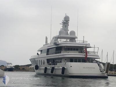
GLADIATOR
Yacht

Current Trip
| Trip Time | 7 days |
|---|---|
| Trip Distance | 300.50 nm |
| AVG Speed | 9.1 Knop |
| MAX Speed | 12.3 Knop |
| Djupgående | 2.7 m |
| AVG Wind | 4.9 knots |
| MAX Wind | 13 knots |
| MIN Temp | 16.6°C / 61.88°F |
| MAX Temp | 24.6°C / 76.28°F |
| Position mottagen | Nu |
Current Position
| Longitud | 7.07862° |
|---|---|
| Latitude | 43.56526° |
| Status | Under way using engine |
| Fart | |
| Kurs | 91° |
| Område | Mediterranean Sea - Western Basin |
| Station | T-AIS |
| Position mottagen | Nu |
Information
The current position of GLADIATOR is in Mediterranean Sea - Western Basin with coordinates 43.56526° / 7.07862° as reported on 2025-06-02 13:06 by AIS to our vessel tracker app. The vessel's current speed is 0 Knop and is currently inside the port of GOLFE JUAN.
The vessel GLADIATOR (IMO: 1010569, MMSI: 319206300) is a Yacht that was built in 2010 ( 15 År gammal ). It's sailing under the flag of [KY] Cayman Is.
In this page you can find informations about the vessels current position, last detected port calls, and current voyage information. If the vessels is not in coverage by AIS you will find the latest position.
The current position of GLADIATOR is detected by our AIS receivers and we are not responsible for the reliability of the data. The last position was recorded while the vessel was in Coverage by the Ais receivers of our vessel tracking app.
The current draught of GLADIATOR as reported by AIS is 2.7 meters
Weather
| Temperature | 22.6°C / 72.68°F |
|---|---|
| Wind Speed | 4 knots |
| Direction | 154° SSE |
| Pressure | 1017.9 hPa |
| Humidity | 72.6 % |
| Cloud Coverage | 100 % |


Featured Company
Last Trips
Events
| Tid | Event | Detaljer | Position / Dest | Information |
|---|---|---|---|---|
| 2025-06-02 12:23 | STOPPAR förflyttning |
43.56488 / 7.07933
[FR] GOLFE JUAN
|
Fart: 0.3 kn Kurs: 8° |
|
| 2025-06-02 12:18 | ANLÄNDER HAMN |
|
43.56305 / 7.07574
[FR] GOLFE JUAN
|
Fart: 2.4 kn Kurs: 44° |
| 2025-06-02 10:47 | Destination ändrad | FR CEQ FR SLDV |
43.64948 / 7.18095
FR CEQ
|
Fart: 9.8 kn Kurs: 211° |
| 2025-06-02 10:47 | ETA ändrat | 2025/06/02 14:00 2025/06/01 07:00 |
43.64948 / 7.18095
FR CEQ
|
Fart: 9.8 kn Kurs: 211° |
| 2025-06-02 10:47 | STARTAR förflyttning | 4.46 nm, North East of ANTIBES |
43.64988 / 7.18128
FR SLDV
|
Fart: 8.9 kn Kurs: 210° |
| 2025-06-02 10:42 | Status ändrad | Under way using engine At anchor |
43.65188 / 7.18212
FR SLDV
|
Fart: Kurs: 129° |
| 2025-06-02 09:22 | Djupgående ändrat | 2.7 2 |
43.65194 / 7.18209
FR SLDV
|
Fart: Kurs: 129° |
| 2025-06-02 09:22 | ETA ändrat | 2025/06/01 07:00 |
43.65194 / 7.18209
FR SLDV
|
Fart: Kurs: 129° |
| 2025-06-02 09:16 | Djupgående ändrat | 2 2.7 |
43.65195 / 7.18214
FR SLDV
|
Fart: Kurs: 117° |
| 2025-06-02 07:28 | Djupgående ändrat | 2.7 2 |
43.65183 / 7.18222
FR SLDV
|
Fart: Kurs: 121° |