

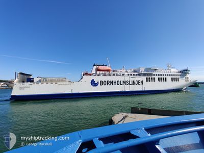
HAMMERSHUS
Passenger A

Current Trip
| Time Travelled | 1 h, 14 mins |
|---|---|
| Remaining Time | 3 h, 40 mins |
| Distance Travelled | 18.82 nm |
| Remaining Distance | 72.32 nm |
| AVG Speed | 17.4 Knop |
| MAX Speed | 19.6 Knop |
| AVG Wind | 8.9 knots |
| MAX Wind | 10 knots |
| MIN Temp | 9.9°C / 49.82°F |
| MAX Temp | 12.9°C / 55.22°F |
| Djupgående | 5.3 m |
| Position mottagen | 1 m sen |
Current Position
| Longitud | 12.71244° |
|---|---|
| Latitude | 55.27926° |
| Status | Under way using engine |
| Fart | 18.5 Knop |
| Kurs | 111° |
| Område | Baltic Sea |
| Station | T-AIS |
| Position mottagen | 1 m sen |
Information
The current position of HAMMERSHUS is in Baltic Sea with coordinates 55.27926° / 12.71244° as reported on 2025-06-05 00:05 by AIS to our vessel tracker app. The vessel's current speed is 18.5 Knop and is heading at the port of ROENNE. The estimated time of arrival as calculated by MyShipTracking vessel tracking app is 2025-06-05 05:46 LT
The vessel HAMMERSHUS (IMO: 9812107, MMSI: 219026000) is a Passenger A It's sailing under the flag of [DK] Denmark.
In this page you can find informations about the vessels current position, last detected port calls, and current voyage information. If the vessels is not in coverage by AIS you will find the latest position.
The current position of HAMMERSHUS is detected by our AIS receivers and we are not responsible for the reliability of the data. The last position was recorded while the vessel was in Coverage by the Ais receivers of our vessel tracking app.
The current draught of HAMMERSHUS as reported by AIS is 5.3 meters
Weather
| Temperature | 12.8°C / 55.04°F |
|---|---|
| Wind Speed | 10 knots |
| Direction | 260° W |
| Pressure | 1007.6 hPa |
| Humidity | 80.9 % |
| Cloud Coverage | 78 % |


Featured Company
Last Port Calls
| Port | Arrival | Departure | Time In Port |
|---|---|---|---|
| 2025-06-04 22:02 | 2025-06-05 00:52 | 2 h | |
| 2025-06-04 05:42 | 2025-06-04 17:02 | 11 h | |
| 2025-06-03 21:59 | 2025-06-04 00:54 | 2 h | |
| 2025-06-03 05:40 | 2025-06-03 17:02 | 11 h | |
| 2025-06-02 22:02 | 2025-06-03 00:51 | 2 h | |
| 2025-06-02 05:41 | 2025-06-02 17:03 | 11 h | |
| 2025-06-01 22:10 | 2025-06-02 00:49 | 2 h | |
| 2025-06-01 14:50 | 2025-06-01 16:58 | 2 h | |
| 2025-06-01 11:05 | 2025-06-01 12:14 | 1 h | |
| 2025-06-01 05:41 | 2025-06-01 08:04 | 2 h |
Most Visited Ports (Last year)
| Port | Arrivals | |
|---|---|---|
| 497 | ||
| 350 | ||
| 133 | ||
| 8 | ||
| 2 |
Last Trips
| Origin | Departure | Destination | Arrival | Distance | |
|---|---|---|---|---|---|
| 2025-06-04 17:02 | 2025-06-04 22:02 | 89.63 nm | |||
| 2025-06-04 00:54 | 2025-06-04 05:42 | 89.90 nm | |||
| 2025-06-03 17:02 | 2025-06-03 21:59 | 89.92 nm | |||
| 2025-06-03 00:51 | 2025-06-03 05:40 | 90.07 nm | |||
| 2025-06-02 17:03 | 2025-06-02 22:02 | 89.65 nm | |||
| 2025-06-02 00:49 | 2025-06-02 05:41 | 87.78 nm | |||
| 2025-06-01 16:58 | 2025-06-01 22:10 | 89.65 nm | |||
| 2025-06-01 12:14 | 2025-06-01 14:50 | 51.16 nm | |||
| 2025-06-01 08:04 | 2025-06-01 11:05 | 54.87 nm | |||
| 2025-06-01 00:27 | 2025-06-01 05:41 | 89.07 nm |
Events
| Tid | Event | Detaljer | Position / Dest | Information |
|---|---|---|---|---|
| 2025-06-04 23:59 | Byter havsområde | Swedish part of the Baltic Sea Danish part of the Baltic Sea |
55.29029 / 12.66183
Baltic Sea
ROENNE
|
Fart: 18.4 kn Kurs: 116.6° |
| 2025-06-04 23:53 | Byter havsområde | Danish part of the Baltic Sea Danish part of the Kattegat |
55.31063 / 12.62021
Baltic Sea
ROENNE
|
Fart: 18.5 kn Kurs: 134.9° |
| 2025-06-04 23:04 | Djupgående ändrat | 5.3 5.4 |
55.45996 / 12.29115
ROENNE
|
Fart: 13.9 kn Kurs: 90.3° |
| 2025-06-04 23:04 | Destination ändrad | ROENNE KOGE |
55.45996 / 12.29115
ROENNE
|
Fart: 13.9 kn Kurs: 90.3° |
| 2025-06-04 23:04 | ETA ändrat | 2025/06/05 04:00 2025/06/04 20:30 |
55.45996 / 12.29115
ROENNE
|
Fart: 13.9 kn Kurs: 90.3° |
| 2025-06-04 22:52 | AVGÅTT HAMN |
|
55.45779 / 12.21390
KOGE
|
Fart: 11.3 kn Kurs: 83° |
| 2025-06-04 22:49 | STARTAR förflyttning |
55.45618 / 12.20009
[DK] KOEGE
|
Fart: 5.7 kn Kurs: 75° |
|
| 2025-06-04 22:34 | Status ändrad | Under way using engine Default |
55.45559 / 12.19693
[DK] KOEGE
|
Fart: Kurs: 110° |
| 2025-06-04 22:31 | Status ändrad | Default Under way using engine |
55.45560 / 12.19691
[DK] KOEGE
|
Fart: Kurs: 110° |
| 2025-06-04 22:26 | Status ändrad | Under way using engine Default |
55.45558 / 12.19696
[DK] KOEGE
|
Fart: Kurs: 110° |