
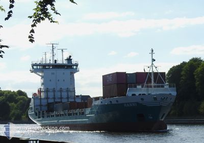
HANNI
Container Ship
Current Trip
| Time Travelled | 3 h, 47 mins |
|---|---|
| Remaining Time | 16 h, 15 mins |
| Distance Travelled | 20.90 nm |
| Remaining Distance | 102.77 nm |
| AVG Speed | 6.7 Knop |
| MAX Speed | 7.3 Knop |
| AVG Wind | 12.5 knots |
| MAX Wind | 14 knots |
| MIN Temp | 2.5°C / 36.5°F |
| MAX Temp | 3.9°C / 39.02°F |
| Djupgående | 6.5 m |
| Position mottagen | 1 m sen |
Current Position
| Longitud | 9.57423° |
|---|---|
| Latitude | 54.20905° |
| Status | Under way using engine |
| Fart | 6.8 Knop |
| Kurs | 231.9° |
| Område | Baltic Sea |
| Station | T-AIS |
| Position mottagen | 1 m sen |
Info
Information
The current position of HANNI is in Baltic Sea with coordinates 54.20905° / 9.57423° as reported on 2025-02-07 12:18 by AIS to our vessel tracker app. The vessel's current speed is 6.8 Knop and is heading at the port of BREMERHAVEN. The estimated time of arrival as calculated by MyShipTracking vessel tracking app is 2025-02-08 04:35 LT
The vessel HANNI (IMO: 9188506, MMSI: 211286440) is a Container Ship that was built in 1998 ( 27 År gammal ). It's sailing under the flag of [DE] Germany.
In this page you can find informations about the vessels current position, last detected port calls, and current voyage information. If the vessels is not in coverage by AIS you will find the latest position.
The current position of HANNI is detected by our AIS receivers and we are not responsible for the reliability of the data. The last position was recorded while the vessel was in Coverage by the Ais receivers of our vessel tracking app.
The current draught of HANNI as reported by AIS is 6.5 meters
Weather
| Temperature | 3.6°C / 38.48°F |
|---|---|
| Wind Speed | 13 knots |
| Direction | 81° E |
| Pressure | 1038.1 hPa |
| Humidity | 74 % |
| Cloud Coverage | 91 % |
Featured Company
Last Port Calls
| Port | Arrival | Departure | Time In Port |
|---|---|---|---|
| 2025-02-07 07:44 | 2025-02-07 08:33 | 49 m | |
| 2025-02-06 07:35 | 2025-02-06 14:10 | 6 h | |
| 2025-02-04 20:40 | 2025-02-05 13:56 | 17 h | |
| 2025-01-31 16:32 | 2025-02-02 18:10 | 2 d | |
| 2025-01-31 00:44 | 2025-01-31 08:38 | 7 h | |
| 2025-01-29 05:23 | 2025-01-29 14:14 | 8 h | |
| 2025-01-28 03:01 | 2025-01-28 12:32 | 9 h | |
| 2025-01-24 22:08 | 2025-01-25 13:49 | 15 h | |
| 2025-01-24 00:21 | 2025-01-24 13:27 | 13 h | |
| 2025-01-22 06:24 | 2025-01-22 17:23 | 10 h |
Most Visited Ports (Last year)
| Port | Arrivals | |
|---|---|---|
| 45 | ||
| 37 | ||
| 31 | ||
| 26 | ||
| 10 | ||
| 6 |
Last Trips
| Origin | Departure | Destination | Arrival | Distance | |
|---|---|---|---|---|---|
| 2025-02-06 15:10 | 2025-02-07 08:44 | 219.30 nm | |||
| 2025-02-05 14:56 | 2025-02-06 08:35 | 272.22 nm | |||
| 2025-02-02 19:10 | 2025-02-04 21:40 | 552.05 nm | |||
| 2025-01-31 09:38 | 2025-01-31 17:32 | 113.88 nm | |||
| 2025-01-29 15:14 | 2025-01-31 01:44 | 352.79 nm | |||
| 2025-01-28 13:32 | 2025-01-29 06:23 | 272.19 nm | |||
| 2025-01-25 14:49 | 2025-01-28 04:01 | 551.00 nm | |||
| 2025-01-24 14:27 | 2025-01-24 23:08 | 116.41 nm | |||
| 2025-01-22 18:23 | 2025-01-24 01:21 | 350.94 nm | |||
| 2025-01-21 14:41 | 2025-01-22 07:24 | 273.24 nm |
Events
| Tid | Event | Detaljer | Position / Dest | Information |
|---|---|---|---|---|
| 2025-02-07 08:33 | AVGÅTT HAMN |
|
54.36661 / 10.13522
DEHTU
|
Fart: 5.6 kn Kurs: 286° |
| 2025-02-07 08:31 | STARTAR förflyttning |
54.36606 / 10.13871
[DE] KIEL
|
Fart: 3.1 kn Kurs: 285° |
|
| 2025-02-07 07:57 | STOPPAR förflyttning |
54.36519 / 10.14392
[DE] KIEL
|
Fart: 0.3 kn Kurs: 282° |
|
| 2025-02-07 07:44 | ANLÄNDER HAMN |
|
54.36333 / 10.16077
[DE] KIEL
|
Fart: 5.3 kn Kurs: 258.7° |
| 2025-02-07 05:59 | Byter havsområde | German part of the Baltic Sea Danish part of the Baltic Sea |
54.56611 / 10.56559
Baltic Sea
DEHTU
|
Fart: 11.9 kn Kurs: 247.3° |
| 2025-02-07 05:20 | Byter havsområde | Danish part of the Baltic Sea German part of the Baltic Sea |
54.58525 / 10.79266
Baltic Sea
DEHTU
|
Fart: 12.5 kn Kurs: 263.5° |
| 2025-02-07 03:53 | Upptäckt i hav | German part of the Baltic Sea |
54.56608 / 11.32685
Baltic Sea
DEHTU
|
Fart: 12.9 kn Kurs: 292.6° |
| 2025-02-06 23:59 | Byter havsområde | Danish part of the Baltic Sea German part of the Baltic Sea |
54.68137 / 12.43176
Baltic Sea
DEHTU
|
Fart: 12.5 kn Kurs: 235.9° |
| 2025-02-06 23:56 | Upptäckt i hav | German part of the Baltic Sea |
54.68740 / 12.44770
Baltic Sea
DEHTU
|
Fart: 12.5 kn Kurs: 237.1° |
| 2025-02-06 22:26 | Byter havsområde | Danish part of the Baltic Sea German part of the Baltic Sea |
54.83381 / 12.92719
Baltic Sea
DEHTU
|
Fart: 12.4 kn Kurs: 249.7° |