

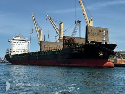
LADY DORIS
General Cargo
Current Trip
| Time Travelled | 17 h, 48 mins |
|---|---|
| Remaining Time | 1 day |
| Distance Travelled | 179.86 nm |
| Remaining Distance | 284.18 nm |
| AVG Speed | 10 Knop |
| MAX Speed | 10.7 Knop |
| AVG Wind | 4 knots |
| MAX Wind | 6.9 knots |
| MIN Temp | 23°C / 73.4°F |
| MAX Temp | 24.4°C / 75.92°F |
| Djupgående | 6.7 m |
| Position mottagen | 1 m sen |
Current Position
| Longitud | 8.09938° |
|---|---|
| Latitude | 41.47660° |
| Status | Under way using engine |
| Fart | 10.1 Knop |
| Kurs | 191.8° |
| Område | Mediterranean Sea - Western Basin |
| Station | T-AIS |
| Position mottagen | 1 m sen |
Information
The current position of LADY DORIS is in Mediterranean Sea - Western Basin with coordinates 41.47660° / 8.09938° as reported on 2025-06-13 00:39 by AIS to our vessel tracker app. The vessel's current speed is 10.1 Knop and is heading at the port of SKIKDA. The estimated time of arrival as calculated by MyShipTracking vessel tracking app is 2025-06-14 05:07 LT
The vessel LADY DORIS (IMO: 9458418, MMSI: 477914400) is a General Cargo that was built in 2012 ( 13 År gammal ). It's sailing under the flag of [HK] Hong Kong.
In this page you can find informations about the vessels current position, last detected port calls, and current voyage information. If the vessels is not in coverage by AIS you will find the latest position.
The current position of LADY DORIS is detected by our AIS receivers and we are not responsible for the reliability of the data. The last position was recorded while the vessel was in Coverage by the Ais receivers of our vessel tracking app.
The current draught of LADY DORIS as reported by AIS is 6.7 meters
Weather
| Temperature | 23.6°C / 74.48°F |
|---|---|
| Wind Speed | 5 knots |
| Direction | 41° NE |
| Pressure | 1016.9 hPa |
| Humidity | 76.8 % |
| Cloud Coverage | 5 % |
Featured Company
Last Port Calls
| Port | Arrival | Departure | Time In Port |
|---|---|---|---|
| 2025-06-09 10:18 | 2025-06-12 08:52 | 2 d | |
| 2025-05-31 10:07 | 2025-06-01 22:45 | 1 d | |
| 2025-05-29 09:15 | 2025-05-29 18:34 | 9 h | |
| 2025-04-24 10:43 | 2025-05-02 20:21 | 8 d | |
| 2025-04-22 20:43 | 2025-04-24 03:10 | 1 d | |
| 2025-04-10 05:26 | 2025-04-10 19:02 | 13 h | |
| 2025-04-07 21:57 | 2025-04-08 22:06 | 1 d |
Most Visited Ports (Last year)
| Port | Arrivals | |
|---|---|---|
| 6 | ||
| 2 | ||
| 2 | ||
| 1 | ||
| 1 | ||
| 1 |
Last Trips
| Origin | Departure | Destination | Arrival | Distance | |
|---|---|---|---|---|---|
| 2025-06-01 22:45 | 2025-06-09 10:18 | 1253.37 nm | |||
| 2025-05-02 20:21 | 2025-05-31 10:07 | 3663.87 nm | |||
| 2025-05-02 20:21 | 2025-05-29 09:15 | 3184.87 nm | |||
| 2025-04-24 03:10 | 2025-04-24 10:43 | 51.47 nm | |||
| 2025-04-10 19:02 | 2025-04-22 20:43 | 460.57 nm | |||
| 2025-04-08 22:06 | 2025-04-10 05:26 | 341.37 nm | |||
| 2025-03-23 23:29 | 2025-04-07 21:57 | 502.46 nm |
Events
| Tid | Event | Detaljer | Position / Dest | Information |
|---|---|---|---|---|
| 2025-06-13 00:17 | Upptäckt i hav | Italian part of the Mediterranean Sea - Western Basin |
41.53757 / 8.11547
Mediterranean Sea - Western Basin
SKIKDA
|
Fart: 10.2 kn Kurs: 190.6° |
| 2025-06-12 13:41 | Byter havsområde | French part of the Mediterranean Sea - Western Basin French part of the Ligurian Sea |
43.14130 / 9.08634
Mediterranean Sea - Western Basin
SKIKDA
|
Fart: 10.2 kn Kurs: 217.6° |
| 2025-06-12 12:16 | ETA ändrat | 2025/06/14 02:00 |
43.33293 / 9.29396
SKIKDA
|
Fart: 10.6 kn Kurs: 218.6° |
| 2025-06-12 11:46 | Byter havsområde | French part of the Ligurian Sea Italian part of the Ligurian Sea |
43.40004 / 9.36844
Ligurian Sea
|
Fart: 10.7 kn Kurs: 218.8° |
| 2025-06-12 09:26 | Upptäckt i hav | Italian part of the Ligurian Sea |
43.71885 / 9.71744
Ligurian Sea
SKIKDA
|
Fart: 10.5 kn Kurs: 221.8° |
| 2025-06-12 06:52 | AVGÅTT HAMN |
|
44.02544 / 10.04535
SKIKDA
|
Fart: 4.5 kn Kurs: 144° |
| 2025-06-12 06:49 | STARTAR förflyttning |
44.02876 / 10.04195
[IT] MARINA DI CARRARA
|
Fart: 4.3 kn Kurs: 140° |
|
| 2025-06-12 06:47 | Djupgående ändrat | 6.7 6.9 |
44.03097 / 10.03982
[IT] MARINA DI CARRARA
|
Fart: 2.5 kn Kurs: 145° |
| 2025-06-12 06:34 | Status ändrad | Under way using engine Moored |
44.03071 / 10.04268
[IT] MARINA DI CARRARA
|
Fart: Kurs: 27° |
| 2025-06-12 05:35 | Destination ändrad | SKIKDA MARINA DI CARRARA |
44.03066 / 10.04267
[IT] MARINA DI CARRARA
|
Fart: Kurs: 27° |