
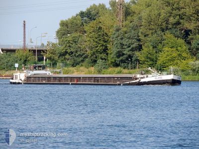
ISLAND
Wing in ground
Current Trip
STETIN
| Time Travelled | 8 days |
|---|---|
| Remaining Time | --- |
| Distance Travelled | 305.65 nm |
| Remaining Distance | --- |
| AVG Speed | 6 Knop |
| MAX Speed | 8.4 Knop |
| AVG Wind | 10.5 knots |
| MAX Wind | 17 knots |
| MIN Temp | -2.1°C / 28.22°F |
| MAX Temp | 5.3°C / 41.54°F |
| Djupgående | 1 m |
| Position mottagen | 7 h, 53 m sen |
Current Position
| Longitud | 14.61414° |
|---|---|
| Latitude | 53.39165° |
| Status | Under way using engine |
| Fart | 1.6 Knop |
| Kurs | 98° |
| Område | North Sea |
| Station | T-AIS |
| Position mottagen | 7 h, 53 m sen |
Info
Information
The current position of ISLAND is in North Sea with coordinates 53.39165° / 14.61414° as reported on 2025-02-11 17:41 by AIS to our vessel tracker app. The vessel's current speed is 1.6 Knop
The vessel ISLAND (MMSI: 261184980) is a Wing in ground It's sailing under the flag of [PL] Poland.
In this page you can find informations about the vessels current position, last detected port calls, and current voyage information. If the vessels is not in coverage by AIS you will find the latest position.
The current position of ISLAND is detected by our AIS receivers and we are not responsible for the reliability of the data. The last position was recorded while the vessel was in Coverage by the Ais receivers of our vessel tracking app.
The current draught of ISLAND as reported by AIS is 1 meters
Weather
| Temperature | -0.6°C / 30.92°F |
|---|---|
| Wind Speed | 10 knots |
| Direction | 97° E |
| Pressure | 1030.4 hPa |
| Humidity | 53.5 % |
| Cloud Coverage | --- |
Featured Company
Last Port Calls
| Port | Arrival | Departure | Time In Port |
|---|---|---|---|
| 2025-02-02 16:48 | 2025-02-03 06:16 | 13 h | |
| 2025-01-18 07:23 | 2025-01-18 08:28 | 1 h | |
| 2025-01-06 12:15 | 2025-01-08 10:56 | 1 d | |
| 2025-01-03 10:46 | 2025-01-03 14:11 | 3 h | |
| 2024-12-27 15:03 | 2024-12-28 08:50 | 17 h | |
| 2024-12-19 19:21 | 2024-12-21 15:12 | 1 d | |
| 2024-12-15 12:22 | 2024-12-15 13:18 | 56 m | |
| 2024-12-07 07:28 | 2024-12-12 08:35 | 5 d | |
| 2024-12-05 11:01 | 2024-12-05 11:40 | 38 m |
Last Trips
| Origin | Departure | Destination | Arrival | Distance | |
|---|---|---|---|---|---|
| 2025-01-18 09:28 | 2025-02-02 17:48 | 492.81 nm | |||
| 2025-01-08 11:56 | 2025-01-18 08:23 | 296.84 nm | |||
| 2025-01-03 15:11 | 2025-01-06 13:15 | 29.34 nm | |||
| 2024-12-28 09:50 | 2025-01-03 11:46 | 136.90 nm | |||
| 2024-12-21 16:12 | 2024-12-27 16:03 | 143.00 nm | |||
| 2024-12-15 14:18 | 2024-12-19 20:21 | 274.88 nm | |||
| 2024-12-12 09:35 | 2024-12-15 13:22 | 18.01 nm | |||
| 2024-12-05 12:40 | 2024-12-07 08:28 | 2.52 nm | |||
| 2024-11-27 13:20 | 2024-12-05 12:01 | 284.22 nm |
Events
| Tid | Event | Detaljer | Position / Dest | Information |
|---|---|---|---|---|
| 2025-02-11 17:41 | UTANFÖR täckningsområde |
53.39165 / 14.61414
North Sea
|
Fart: 1.6 kn Kurs: 42.2° |
|
| 2025-02-11 17:21 | I täckningsområde |
53.36560 / 14.58373
North Sea
|
Fart: 7.6 kn Kurs: 45.2° |
|
| 2025-02-11 07:40 | UTANFÖR täckningsområde |
52.84705 / 13.45046
North Sea
|
Fart: 6.1 kn Kurs: 87.7° |
|
| 2025-02-11 07:27 | I täckningsområde |
52.84445 / 13.42789
North Sea
|
Fart: 5.9 kn Kurs: 76.2° |
|
| 2025-02-11 06:27 | UTANFÖR täckningsområde |
52.78522 / 13.28082
North Sea
|
Fart: 5.9 kn Kurs: 4.8° |
|
| 2025-02-11 06:22 | I täckningsområde |
52.78275 / 13.28045
North Sea
|
Fart: 6.2 kn Kurs: 3.4° |
|
| 2025-02-10 16:31 | UTANFÖR täckningsområde |
52.71488 / 13.24510
North Sea
|
Fart: 6 kn Kurs: 5.4° |
|
| 2025-02-10 14:18 | STARTAR förflyttning | 7.33 nm, West of BERLIN |
52.54158 / 13.20872
STETIN
|
Fart: 3.5 kn Kurs: 358° |
| 2025-02-10 14:18 | Status ändrad | Under way using engine Moored |
52.54113 / 13.20889
STETIN
|
Fart: 0.1 kn Kurs: 355° |
| 2025-02-10 14:08 | Status ändrad | Moored Under way using engine |
52.54034 / 13.20906
STETIN
|
Fart: 0.1 kn Kurs: 353° |