
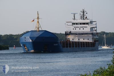
KAARI
General Cargo
Current Trip
| Time Travelled | 4 days |
|---|---|
| Remaining Time | --- |
| Distance Travelled | 139.79 nm |
| Remaining Distance | --- |
| AVG Speed | 8.9 Knop |
| MAX Speed | 11.2 Knop |
| AVG Wind | 14 knots |
| MAX Wind | 23.5 knots |
| MIN Temp | 0.5°C / 32.9°F |
| MAX Temp | 4.8°C / 40.64°F |
| Djupgående | 5.1 m |
| Position mottagen | 2 d sen |
Current Position
| Longitud | 13.66069° |
|---|---|
| Latitude | 54.42206° |
| Status | At anchor |
| Fart | 0.1 Knop |
| Kurs | 320° |
| Område | Baltic Sea |
| Station | T-AIS |
| Position mottagen | 2 d sen |
Info
Information
The current position of KAARI is in Baltic Sea with coordinates 54.42206° / 13.66069° as reported on 2025-02-06 10:49 by AIS to our vessel tracker app. The vessel's current speed is 0.1 Knop
The vessel KAARI (IMO: 9434761, MMSI: 305342000) is a General Cargo that was built in 2009 ( 16 År gammal ). It's sailing under the flag of [AG] Antigua Barbuda.
In this page you can find informations about the vessels current position, last detected port calls, and current voyage information. If the vessels is not in coverage by AIS you will find the latest position.
The current position of KAARI is detected by our AIS receivers and we are not responsible for the reliability of the data. The last position was recorded while the vessel was in Coverage by the Ais receivers of our vessel tracking app.
The current draught of KAARI as reported by AIS is 5.1 meters
Weather
| Temperature | 2.4°C / 36.32°F |
|---|---|
| Wind Speed | 11 knots |
| Direction | 93° E |
| Pressure | 1033.3 hPa |
| Humidity | 73.8 % |
| Cloud Coverage | 97 % |
Featured Company
Last Port Calls
| Port | Arrival | Departure | Time In Port |
|---|---|---|---|
| 2025-02-03 18:38 | 2025-02-04 19:18 | 1 d | |
| 2025-01-25 16:53 | 2025-01-31 19:17 | 6 d | |
| 2025-01-17 09:22 | 2025-01-21 17:06 | 4 d | |
| 2025-01-13 13:07 | 2025-01-14 13:54 | 1 d | |
| 2025-01-06 23:03 | 2025-01-08 08:39 | 1 d | |
| 2024-12-29 19:04 | 2025-01-02 21:45 | 4 d | |
| 2024-12-25 09:57 | 2024-12-27 17:26 | 2 d | |
| 2024-12-23 10:14 | 2024-12-23 10:29 | 14 m | |
| 2024-12-14 04:24 | 2024-12-23 08:49 | 9 d | |
| 2024-12-14 01:39 |
Most Visited Ports (Last year)
| Port | Arrivals | |
|---|---|---|
| 13 | ||
| 4 | ||
| 3 | ||
| 3 | ||
| 3 | ||
| 3 |
Last Trips
| Origin | Departure | Destination | Arrival | Distance | |
|---|---|---|---|---|---|
| 2025-01-31 22:17 | 2025-02-03 19:38 | 764.53 nm | |||
| 2025-01-21 18:06 | 2025-01-25 19:53 | 746.31 nm | |||
| 2025-01-14 16:54 | 2025-01-17 10:22 | 649.73 nm | |||
| 2025-01-08 09:39 | 2025-01-13 16:07 | 590.96 nm | |||
| 2025-01-03 00:45 | 2025-01-07 00:03 | 576.23 nm | |||
| 2024-12-27 19:26 | 2024-12-29 22:04 | 480.84 nm | |||
| 2024-12-23 13:29 | 2024-12-25 11:57 | 470.66 nm | |||
| 2024-12-23 11:49 | 2024-12-23 13:14 | 12.22 nm | |||
| 2024-12-14 03:58 | 2024-12-14 07:24 | 13.90 nm | |||
| 2024-12-05 06:24 | 2024-12-14 04:39 | 1834.70 nm |
Events
| Tid | Event | Detaljer | Position / Dest | Information |
|---|---|---|---|---|
| 2025-02-06 10:52 | Status ändrad | Default At anchor |
54.42201 / 13.66061
DEVIW
|
Fart: 0.1 kn Kurs: 320° |
| 2025-02-06 10:49 | Status ändrad | At anchor Default |
54.42206 / 13.66069
DEVIW
|
Fart: Kurs: 318° |
| 2025-02-06 10:49 | UTANFÖR täckningsområde |
54.42206 / 13.66069
Baltic Sea
|
Fart: 0.1 kn Kurs: 121.9° |
|
| 2025-02-06 10:31 | Status ändrad | Default At anchor |
54.42194 / 13.66052
DEVIW
|
Fart: 0.1 kn Kurs: 342° |
| 2025-02-06 10:28 | Status ändrad | At anchor Default |
54.42190 / 13.66029
DEVIW
|
Fart: Kurs: 343° |
| 2025-02-06 10:19 | Status ändrad | Default At anchor |
54.42190 / 13.66043
DEVIW
|
Fart: Kurs: 333° |
| 2025-02-06 10:15 | Status ändrad | At anchor Default |
54.42194 / 13.66046
DEVIW
|
Fart: Kurs: 333° |
| 2025-02-06 09:25 | Status ändrad | Default At anchor |
54.42203 / 13.66034
DEVIW
|
Fart: Kurs: 334° |
| 2025-02-06 09:18 | Status ändrad | At anchor Default |
54.42192 / 13.66022
DEVIW
|
Fart: Kurs: 332° |
| 2025-02-06 09:07 | I täckningsområde |
54.42192 / 13.66022
Baltic Sea
|
Fart: Kurs: 121.9° |