
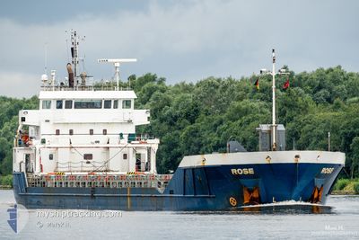
LONGROSE
General Cargo
Current Trip
| Time Travelled | 1 day |
|---|---|
| Remaining Time | 6 h, 17 mins |
| Distance Travelled | 491.59 nm |
| Remaining Distance | 67.26 nm |
| AVG Speed | 10.3 Knop |
| MAX Speed | 13.5 Knop |
| AVG Wind | 11.6 knots |
| MAX Wind | 18 knots |
| MIN Temp | 5.1°C / 41.18°F |
| MAX Temp | 11.4°C / 52.52°F |
| Djupgående | 3.6 m |
| Position mottagen | Nu |
Current Position
| Longitud | -2.52583° |
|---|---|
| Latitude | 46.59510° |
| Status | Under way using engine |
| Fart | 10.3 Knop |
| Kurs | 127.3° |
| Område | Bay of Biscay |
| Station | T-AIS |
| Position mottagen | Nu |
Info
Information
The current position of LONGROSE is in Bay of Biscay with coordinates 46.59510° / -2.52583° as reported on 2025-02-04 10:54 by AIS to our vessel tracker app. The vessel's current speed is 10.3 Knop and is heading at the port of LA PALLICE. The estimated time of arrival as calculated by MyShipTracking vessel tracking app is 2025-02-04 17:12 LT
The vessel LONGROSE (IMO: 9521368, MMSI: 246227000) is a General Cargo that was built in 2012 ( 13 År gammal ). It's sailing under the flag of [NL] Netherlands.
In this page you can find informations about the vessels current position, last detected port calls, and current voyage information. If the vessels is not in coverage by AIS you will find the latest position.
The current position of LONGROSE is detected by our AIS receivers and we are not responsible for the reliability of the data. The last position was recorded while the vessel was in Coverage by the Ais receivers of our vessel tracking app.
The current draught of LONGROSE as reported by AIS is 3.6 meters
Weather
| Temperature | 11.1°C / 51.98°F |
|---|---|
| Wind Speed | 10 knots |
| Direction | 200° SSW |
| Pressure | 1026.9 hPa |
| Humidity | 81.5 % |
| Cloud Coverage | --- |
Featured Company
Last Port Calls
| Port | Arrival | Departure | Time In Port |
|---|---|---|---|
| 2025-01-30 10:46 | 2025-02-02 11:48 | 3 d | |
| 2025-01-17 20:40 | 2025-01-22 00:26 | 4 d | |
| 2025-01-15 20:20 | 2025-01-16 20:05 | 23 h | |
| 2025-01-13 22:22 | 2025-01-14 19:02 | 20 h | |
| 2024-12-11 23:58 | 2024-12-15 02:03 | 3 d |
Most Visited Ports (Last year)
| Port | Arrivals | |
|---|---|---|
| 3 | ||
| 2 | ||
| 2 | ||
| 2 | ||
| 2 | ||
| 2 |
Last Trips
| Origin | Departure | Destination | Arrival | Distance | |
|---|---|---|---|---|---|
| 2025-01-22 01:26 | 2025-01-30 10:46 | 147.26 nm | |||
| 2025-01-16 20:05 | 2025-01-17 21:40 | 245.00 nm | |||
| 2025-01-14 20:02 | 2025-01-15 20:20 | 221.38 nm | |||
| 2024-12-14 22:03 | 2025-01-13 23:22 | 5201.01 nm | |||
| 2024-11-23 17:50 | 2024-12-11 19:58 | 4145.43 nm |
Events
| Tid | Event | Detaljer | Position / Dest | Information |
|---|---|---|---|---|
| 2025-02-04 08:00 | ETA ändrat | 2025/02/04 17:00 2025/02/04 19:00 |
46.89818 / -3.09845
FRLPE
|
Fart: 10.5 kn Kurs: 127.5° |
| 2025-02-04 02:57 | Status ändrad | Under way using engine Default |
47.46562 / -4.17950
FRLPE
|
Fart: 10.8 kn Kurs: 127° |
| 2025-02-04 02:48 | Status ändrad | Default Under way using engine |
47.48117 / -4.20928
FRLPE
|
Fart: 10.8 kn Kurs: 125.9° |
| 2025-02-04 01:23 | Upptäckt i hav | French part of the Bay of Biscay |
47.63348 / -4.50133
Bay of Biscay
FRLPE
|
Fart: 10.4 kn Kurs: 127.7° |
| 2025-02-03 21:36 | Status ändrad | Under way using engine Default |
48.07443 / -5.34818
FRLPE
|
Fart: 11.1 kn Kurs: 170° |
| 2025-02-03 21:18 | Status ändrad | Default Under way using engine |
48.13163 / -5.35905
FRLPE
|
Fart: 11.1 kn Kurs: 172.3° |
| 2025-02-03 21:06 | Status ändrad | Under way using engine Default |
48.16590 / -5.36570
FRLPE
|
Fart: 10.7 kn Kurs: 173° |
| 2025-02-03 20:58 | I täckningsområde |
48.16287 / -5.36523
Celtic Sea
FRLPE
|
Fart: 11 kn Kurs: 175.7° |
|
| 2025-02-03 19:13 | Status ändrad | Default Under way using engine |
48.46998 / -5.42387
FRLPE
|
Fart: 8.4 kn Kurs: 172° |
| 2025-02-03 19:10 | UTANFÖR täckningsområde |
48.47742 / -5.42517
Celtic Sea
FRLPE
|
Fart: 8.4 kn Kurs: 172° |