
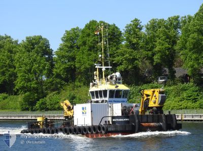
MULTRASALVOR 3
Utility Vessel
Current Trip
DKROD
| Time Travelled | --- |
|---|---|
| Remaining Time | --- |
| Distance Travelled | 242.19 nm |
| Remaining Distance | --- |
| AVG Speed | 5.4 Knop |
| MAX Speed | 10.1 Knop |
| AVG Wind | 10.8 knots |
| MAX Wind | 22 knots |
| MIN Temp | 13.5°C / 56.3°F |
| MAX Temp | 24.1°C / 75.38°F |
| Djupgående | 2.6 m |
| Position mottagen | 1 m sen |
Current Position
| Longitud | 11.37378° |
|---|---|
| Latitude | 54.63777° |
| Status | Under way using engine |
| Fart | |
| Kurs | 329° |
| Område | Baltic Sea |
| Station | T-AIS |
| Position mottagen | 1 m sen |
Information
The current position of MULTRASALVOR 3 is in Baltic Sea with coordinates 54.63777° / 11.37378° as reported on 2025-03-26 16:58 by AIS to our vessel tracker app. The vessel's current speed is 0 Knop
The vessel MULTRASALVOR 3 (IMO: 9635975, MMSI: 245489000) is a Utility Vessel that was built in 2012 ( 13 År gammal ). It's sailing under the flag of [NL] Netherlands.
In this page you can find informations about the vessels current position, last detected port calls, and current voyage information. If the vessels is not in coverage by AIS you will find the latest position.
The current position of MULTRASALVOR 3 is detected by our AIS receivers and we are not responsible for the reliability of the data. The last position was recorded while the vessel was in Coverage by the Ais receivers of our vessel tracking app.
The current draught of MULTRASALVOR 3 as reported by AIS is 2.6 meters
Weather
| Temperature | 9.3°C / 48.74°F |
|---|---|
| Wind Speed | 6 knots |
| Direction | 320° NW |
| Pressure | 1018.5 hPa |
| Humidity | 65.4 % |
| Cloud Coverage | 19 % |
Featured Company
Last Port Calls
Last Trips
| Origin | Departure | Destination | Arrival | Distance |
|---|
Events
| Tid | Event | Detaljer | Position / Dest | Information |
|---|---|---|---|---|
| 2025-03-25 15:23 | STOPPAR förflyttning | 1.28 nm, South East of RODBYHAVN |
54.63755 / 11.37471
DKROD
|
Fart: 0.3 kn Kurs: 226° |
| 2025-03-25 15:21 | STARTAR förflyttning | 1.32 nm, South East of RODBYHAVN |
54.63860 / 11.37795
DKROD
|
Fart: 4.6 kn Kurs: 226° |
| 2025-03-25 07:26 | STOPPAR förflyttning | 1.3 nm, South East of RODBYHAVN |
54.64025 / 11.37919
DKROD
|
Fart: 0.2 kn Kurs: 1° |
| 2025-03-25 07:23 | STARTAR förflyttning | 1.31 nm, South East of RODBYHAVN |
54.63790 / 11.37648
DKROD
|
Fart: 4.1 kn Kurs: 39° |
| 2025-03-24 17:13 | STOPPAR förflyttning | 1.21 nm, South East of RODBYHAVN |
54.63881 / 11.37377
DKROD
|
Fart: 0.2 kn Kurs: 33° |
| 2025-03-24 17:09 | STARTAR förflyttning | 1.33 nm, South East of RODBYHAVN |
54.63853 / 11.37796
DKROD
|
Fart: 5 kn Kurs: 222.8° |
| 2025-03-24 09:06 | STOPPAR förflyttning | 1.3 nm, South East of RODBYHAVN |
54.64024 / 11.37923
DKROD
|
Fart: 0.3 kn Kurs: 13° |
| 2025-03-24 09:04 | STARTAR förflyttning | 1.3 nm, South East of RODBYHAVN |
54.63873 / 11.37739
DKROD
|
Fart: 4.8 kn Kurs: 34° |
| 2025-03-21 11:08 | STOPPAR förflyttning | 1.22 nm, South East of RODBYHAVN |
54.63868 / 11.37415
DKROD
|
Fart: 0.3 kn Kurs: 21° |
| 2025-03-21 11:05 | STARTAR förflyttning | 1.35 nm, South East of RODBYHAVN |
54.63810 / 11.37818
DKROD
|
Fart: 4.5 kn Kurs: 254° |