
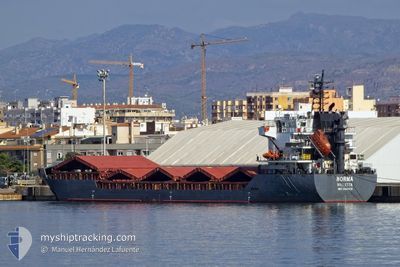
NORMA
General Cargo
Current Trip
IT QOS
| Time Travelled | 1 day |
|---|---|
| Remaining Time | --- |
| Distance Travelled | 277.69 nm |
| Remaining Distance | --- |
| AVG Speed | 9.1 Knop |
| MAX Speed | 9.9 Knop |
| AVG Wind | 12.7 knots |
| MAX Wind | 22.2 knots |
| MIN Temp | 11.3°C / 52.34°F |
| MAX Temp | 12.7°C / 54.86°F |
| Djupgående | 6.6 m |
| Position mottagen | 40 m sen |
Current Position
| Longitud | 2.29933° |
|---|---|
| Latitude | 39.95433° |
| Status | Under way using engine |
| Fart | 10.1 Knop |
| Kurs | 268° |
| Område | Balearic Sea |
| Station | T-AIS |
| Position mottagen | 40 m sen |
Info
Information
The current position of NORMA is in Balearic Sea with coordinates 39.95433° / 2.29933° as reported on 2025-02-02 19:14 by AIS to our vessel tracker app. The vessel's current speed is 10.1 Knop
The vessel NORMA (IMO: 9306419, MMSI: 256161000) is a General Cargo that was built in 2006 ( 19 År gammal ). It's sailing under the flag of [MT] Malta.
In this page you can find informations about the vessels current position, last detected port calls, and current voyage information. If the vessels is not in coverage by AIS you will find the latest position.
The current position of NORMA is detected by our AIS receivers and we are not responsible for the reliability of the data. The last position was recorded while the vessel was in Coverage by the Ais receivers of our vessel tracking app.
The current draught of NORMA as reported by AIS is 6.6 meters
Weather
| Temperature | 12.7°C / 54.86°F |
|---|---|
| Wind Speed | 12 knots |
| Direction | 340° NNW |
| Pressure | 1019.6 hPa |
| Humidity | 61.2 % |
| Cloud Coverage | 100 % |
Featured Company
Last Port Calls
| Port | Arrival | Departure | Time In Port |
|---|---|---|---|
| 2025-01-27 06:55 | 2025-02-01 08:24 | 5 d | |
| 2025-01-13 05:19 | 2025-01-16 13:49 | 3 d | |
| 2024-12-30 06:56 | 2024-12-31 08:00 | 1 d | |
| 2024-12-24 02:07 | 2024-12-25 17:29 | 1 d | |
| 2024-12-23 02:56 | 2024-12-23 17:36 | 14 h | |
| 2024-12-18 01:17 | 2024-12-18 22:35 | 21 h | |
| 2024-12-04 17:35 |
Most Visited Ports (Last year)
| Port | Arrivals | |
|---|---|---|
| 3 | ||
| 3 | ||
| 3 | ||
| 3 | ||
| 1 | ||
| 1 |
Last Trips
| Origin | Departure | Destination | Arrival | Distance | |
|---|---|---|---|---|---|
| 2025-01-16 16:49 | 2025-01-27 07:55 | 1769.18 nm | |||
| 2024-12-31 11:00 | 2025-01-13 08:19 | 428.89 nm | |||
| 2024-12-25 20:29 | 2024-12-30 09:56 | 310.56 nm | |||
| 2024-12-23 20:36 | 2024-12-24 05:07 | 72.21 nm | |||
| 2024-12-19 01:35 | 2024-12-23 05:56 | 852.16 nm | |||
| 2024-12-04 18:35 | 2024-12-18 04:17 | 2892.40 nm |
Events
| Tid | Event | Detaljer | Position / Dest | Information |
|---|---|---|---|---|
| 2025-02-02 14:04 | Byter havsområde | Spanish part of the Balearic Sea Italian part of the Mediterranean Sea - Eastern Basin |
40.21967 / 3.25116
Balearic Sea
|
Fart: 8.4 kn Kurs: 247.9° |
| 2025-02-02 14:04 | I täckningsområde |
40.21967 / 3.25116
Balearic Sea
|
Fart: 8.4 kn Kurs: 247.9° |
|
| 2025-02-01 08:24 | AVGÅTT HAMN |
|
39.82283 / 8.27267
IT QOS
|
Fart: Kurs: 245° |
| 2025-01-27 07:24 | STOPPAR förflyttning |
39.86383 / 8.55600
[IT] ORISTANO
|
Fart: Kurs: 263° |
|
| 2025-01-27 06:55 | ANLÄNDER HAMN |
|
39.86309 / 8.54364
[IT] ORISTANO
|
Fart: Kurs: 191° |
| 2025-01-25 15:51 | STOPPAR förflyttning | 3.23 nm, West of ORISTANO |
39.86286 / 8.47823
IT QOS
|
Fart: 0.1 kn Kurs: 188° |
| 2025-01-24 01:50 | Status ändrad | Default Under way using engine |
36.97883 / 13.74517
IT QOS
|
Fart: 9.6 kn Kurs: 299° |
| 2025-01-24 01:48 | Status ändrad | Under way using engine Default |
36.97683 / 13.74983
IT QOS
|
Fart: 9.5 kn Kurs: 302° |
| 2025-01-24 01:48 | UTANFÖR täckningsområde |
36.97683 / 13.74983
Mediterranean Sea - Eastern Basin
IT QOS
|
Fart: 9.6 kn Kurs: 299° |
|
| 2025-01-24 01:30 | Status ändrad | Default Under way using engine |
36.95216 / 13.80150
IT QOS
|
Fart: 9.5 kn Kurs: 301° |