

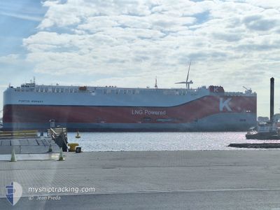
PONTUS HIGHWAY
Cargo

Current Trip
| Time Travelled | 16 days |
|---|---|
| Remaining Time | 15 days |
| Distance Travelled | 5661.60 nm |
| Remaining Distance | 5615.98 nm |
| AVG Speed | 15.8 Knop |
| MAX Speed | 18.9 Knop |
| AVG Wind | 12.1 knots |
| MAX Wind | 21 knots |
| MIN Temp | 14.4°C / 57.92°F |
| MAX Temp | 23.9°C / 75.02°F |
| Djupgående | 9.6 m |
| Position mottagen | 16 h, 26 m sen |
Current Position
| Longitud | 18.35639° |
|---|---|
| Latitude | -34.58163° |
| Status | Under way using engine |
| Fart | 15.5 Knop |
| Kurs | 129.9° |
| Område | South Atlantic Ocean |
| Station | T-AIS |
| Position mottagen | 16 h, 26 m sen |
Information
The current position of PONTUS HIGHWAY is in South Atlantic Ocean with coordinates -34.58163° / 18.35639° as reported on 2025-06-11 10:49 by AIS to our vessel tracker app. The vessel's current speed is 15.5 Knop and is heading at the port of SINGAPORE. The estimated time of arrival as calculated by MyShipTracking vessel tracking app is 2025-06-27 14:34 LT
The vessel PONTUS HIGHWAY (IMO: 9974113, MMSI: 352004564) is a Cargo It's sailing under the flag of [PA] Panama.
In this page you can find informations about the vessels current position, last detected port calls, and current voyage information. If the vessels is not in coverage by AIS you will find the latest position.
The current position of PONTUS HIGHWAY is detected by our AIS receivers and we are not responsible for the reliability of the data. The last position was recorded while the vessel was in Coverage by the Ais receivers of our vessel tracking app.
The current draught of PONTUS HIGHWAY as reported by AIS is 9.6 meters
Weather
| Temperature | 15.1°C / 59.18°F |
|---|---|
| Wind Speed | 9 knots |
| Direction | 121° ESE |
| Pressure | 1029.8 hPa |
| Humidity | 70.6 % |
| Cloud Coverage | 3 % |


Featured Company
Last Port Calls
| Port | Arrival | Departure | Time In Port |
|---|---|---|---|
| 2025-05-26 09:10 | 2025-05-26 20:34 | 11 h | |
| 2025-05-18 12:42 | 2025-05-21 22:14 | 3 d | |
| 2025-05-15 18:06 | 2025-05-17 01:12 | 1 d | |
| 2025-05-14 04:16 | 2025-05-14 19:01 | 14 h | |
| 2025-05-11 19:58 | 2025-05-12 16:08 | 20 h | |
| 2025-04-28 08:55 | 2025-04-29 04:46 | 19 h | |
| 2025-04-25 22:20 | 2025-04-27 17:30 | 1 d | |
| 2025-04-22 19:22 | 2025-04-23 19:26 | 1 d | |
| 2025-04-21 20:01 | 2025-04-22 19:09 | 23 h | |
| 2025-04-21 05:30 | 2025-04-21 18:54 | 13 h |
Most Visited Ports (Last year)
| Port | Arrivals | |
|---|---|---|
| 3 | ||
| 3 | ||
| 3 | ||
| 2 | ||
| 2 | ||
| 2 |
Last Trips
| Origin | Departure | Destination | Arrival | Distance | |
|---|---|---|---|---|---|
| 2025-05-21 22:14 | 2025-05-26 09:10 | 1223.59 nm | |||
| 2025-05-17 01:12 | 2025-05-18 12:42 | 331.86 nm | |||
| 2025-05-14 19:01 | 2025-05-15 18:06 | 71.31 nm | |||
| 2025-05-12 16:08 | 2025-05-14 04:16 | 482.17 nm | |||
| 2025-04-29 04:46 | 2025-05-11 19:58 | 3586.56 nm | |||
| 2025-04-27 17:30 | 2025-04-28 08:55 | 167.88 nm | |||
| 2025-04-23 19:26 | 2025-04-25 22:20 | 674.88 nm | |||
| 2025-04-22 19:09 | 2025-04-22 19:22 | 0.95 nm | |||
| 2025-04-21 18:54 | 2025-04-21 20:01 | 5.46 nm | |||
| 2025-04-08 01:45 | 2025-04-21 05:30 | 3740.60 nm |
Events
| Tid | Event | Detaljer | Position / Dest | Information |
|---|---|---|---|---|
| 2025-06-11 10:49 | UTANFÖR täckningsområde |
-34.58163 / 18.35639
South Atlantic Ocean
SG SIN
|
Fart: 15.5 kn Kurs: 129.9° |
|
| 2025-06-11 08:22 | Byter havsområde | South African part of the South Atlantic Ocean Senegalese part of the North Atlantic Ocean |
-34.11612 / 17.91395
South Atlantic Ocean
SG SIN
|
Fart: 14.7 kn Kurs: 153.3° |
| 2025-06-11 08:21 | I täckningsområde |
-34.11612 / 17.91395
South Atlantic Ocean
SG SIN
|
Fart: 14.7 kn Kurs: 153.3° |