
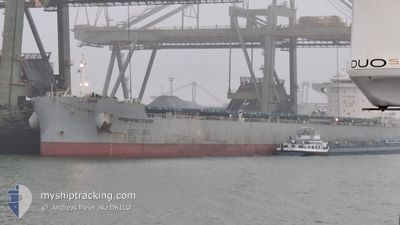
PROGRESS TRADER
Cargo
Current Trip
| Time Travelled | 1 day |
|---|---|
| Remaining Time | --- |
| Distance Travelled | 222.12 nm |
| Remaining Distance | --- |
| AVG Speed | 10 Knop |
| MAX Speed | 13.3 Knop |
| AVG Wind | 12.4 knots |
| MAX Wind | 31 knots |
| MIN Temp | 12.5°C / 54.5°F |
| MAX Temp | 15.1°C / 59.18°F |
| Djupgående | 7.6 m |
| Position mottagen | 1 d sen |
Current Position
| Longitud | 3.56718° |
|---|---|
| Latitude | 42.11397° |
| Status | Under way using engine |
| Fart | 5.4 Knop |
| Kurs | 13.7° |
| Område | Mediterranean Sea - Western Basin |
| Station | T-AIS |
| Position mottagen | 1 d sen |
Info
Information
The current position of PROGRESS TRADER is in Mediterranean Sea - Western Basin with coordinates 42.11397° / 3.56718° as reported on 2025-12-21 13:02 by AIS to our vessel tracker app. The vessel's current speed is 5.4 Knop
The vessel PROGRESS TRADER (IMO: 9936769, MMSI: 352001703) is a Cargo It's sailing under the flag of [PA] Panama.
In this page you can find informations about the vessels current position, last detected port calls, and current voyage information. If the vessels is not in coverage by AIS you will find the latest position.
The current position of PROGRESS TRADER is detected by our AIS receivers and we are not responsible for the reliability of the data. The last position was recorded while the vessel was in Coverage by the Ais receivers of our vessel tracking app.
The current draught of PROGRESS TRADER as reported by AIS is 7.6 meters
Weather
| Temperature | 8.3°C / 46.94°F |
|---|---|
| Wind Speed | 24 knots |
| Direction | 308° NW |
| Pressure | 1005.5 hPa |
| Humidity | 89.4 % |
| Cloud Coverage | 100 % |
Featured Company
Last Port Calls
| Port | Arrival | Departure | Time In Port |
|---|---|---|---|
| 2025-12-11 21:31 | 2025-12-21 01:04 | 9 d | |
| 2025-11-08 01:32 | 2025-11-12 21:21 | 4 d |
Most Visited Ports (Last year)
| Port | Arrivals | |
|---|---|---|
| 2 | ||
| 2 | ||
| 2 | ||
| 2 | ||
| 2 | ||
| 2 |
Last Trips
| Origin | Departure | Destination | Arrival | Distance | |
|---|---|---|---|---|---|
| 2025-11-12 21:21 | 2025-12-11 21:31 | 6060.21 nm | |||
| 2025-09-26 23:02 | 2025-11-08 01:32 | 9055.67 nm |
Events
| Tid | Event | Detaljer | Position / Dest | Information |
|---|---|---|---|---|
| 2025-12-21 13:02 | UTANFÖR täckningsområde |
42.11397 / 3.56718
Mediterranean Sea - Western Basin
FR SET
|
Fart: 5.4 kn Kurs: 13.7° |
|
| 2025-12-21 13:02 | Status ändrad | Under way using engine Default |
42.11397 / 3.56718
FR SET
|
Fart: 5 kn Kurs: 14° |
| 2025-12-21 12:45 | Status ändrad | Default Under way using engine |
42.09085 / 3.55931
FR SET
|
Fart: 4.6 kn Kurs: 15° |
| 2025-12-21 08:58 | Byter havsområde | Spanish part of the Mediterranean Sea - Western Basin Spanish part of the Balearic Sea |
41.69790 / 3.35414
Mediterranean Sea - Western Basin
FR SET
|
Fart: 12.7 kn Kurs: 45° |
| 2025-12-21 00:04 | AVGÅTT HAMN |
|
41.06870 / 1.19944
FR SET
|
Fart: 7.1 kn Kurs: 194° |
| 2025-12-20 23:59 | Status ändrad | Under way using engine Default |
41.07599 / 1.20542
[ES] TARRAGONA
|
Fart: 7.1 kn Kurs: 219° |
| 2025-12-20 23:54 | Status ändrad | Default Under way using engine |
41.08440 / 1.21420
[ES] TARRAGONA
|
Fart: 5.5 kn Kurs: 219° |
| 2025-12-20 23:43 | STARTAR förflyttning |
41.09744 / 1.22787
[ES] TARRAGONA
|
Fart: 3.9 kn Kurs: 220° |
|
| 2025-12-20 23:20 | Status ändrad | Under way using engine Moored |
41.10332 / 1.22906
[ES] TARRAGONA
|
Fart: Kurs: 347° |
| 2025-12-20 23:18 | Status ändrad | Moored Default |
41.10331 / 1.22907
[ES] TARRAGONA
|
Fart: Kurs: 347° |