
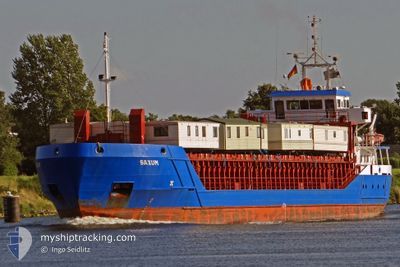
RDJ MAASSTROOM
General Cargo
Current Trip
| Time Travelled | 1 day |
|---|---|
| Remaining Time | 4 h, 50 mins |
| Distance Travelled | 199.75 nm |
| Remaining Distance | 175.75 nm |
| AVG Speed | 8.7 Knop |
| MAX Speed | 14.6 Knop |
| AVG Wind | 6.4 knots |
| MAX Wind | 16 knots |
| MIN Temp | -1.5°C / 29.3°F |
| MAX Temp | 6.6°C / 43.88°F |
| Djupgående | 3.4 m |
| Position mottagen | 12 h, 38 m sen |
Current Position
| Longitud | 5.21833° |
|---|---|
| Latitude | 53.60191° |
| Status | Under way using engine |
| Fart | 11.3 Knop |
| Kurs | 252° |
| Område | North Sea |
| Station | T-AIS |
| Position mottagen | 12 h, 38 m sen |
Info
Information
The current position of RDJ MAASSTROOM is in North Sea with coordinates 53.60191° / 5.21833° as reported on 2025-02-03 16:16 by AIS to our vessel tracker app. The vessel's current speed is 11.3 Knop and is heading at the port of BRUGGE. The estimated time of arrival as calculated by MyShipTracking vessel tracking app is 2025-02-04 10:44 LT
The vessel RDJ MAASSTROOM (IMO: 9197818, MMSI: 246391000) is a General Cargo that was built in 2000 ( 25 År gammal ). It's sailing under the flag of [NL] Netherlands.
In this page you can find informations about the vessels current position, last detected port calls, and current voyage information. If the vessels is not in coverage by AIS you will find the latest position.
The current position of RDJ MAASSTROOM is detected by our AIS receivers and we are not responsible for the reliability of the data. The last position was recorded while the vessel was in Coverage by the Ais receivers of our vessel tracking app.
The current draught of RDJ MAASSTROOM as reported by AIS is 3.4 meters
Weather
| Temperature | 8.5°C / 47.3°F |
|---|---|
| Wind Speed | 17 knots |
| Direction | 232° SW |
| Pressure | 1023.5 hPa |
| Humidity | 80.7 % |
| Cloud Coverage | 100 % |
Featured Company
Last Port Calls
| Port | Arrival | Departure | Time In Port |
|---|---|---|---|
| 2025-02-03 00:05 | 2025-02-03 02:08 | 2 h | |
| 2025-01-31 08:04 | 2025-02-01 19:26 | 1 d | |
| 2025-01-22 12:53 | 2025-01-27 18:43 | 5 d | |
| 2025-01-20 15:08 | 2025-01-21 11:11 | 20 h | |
| 2025-01-15 03:09 | 2025-01-17 17:11 | 2 d | |
| 2025-01-12 21:24 | 2025-01-14 17:50 | 1 d | |
| 2025-01-09 18:15 | |||
| 2025-01-03 10:16 | 2025-01-04 06:46 | 20 h | |
| 2024-12-17 17:02 | 2024-12-20 16:35 | 2 d | |
| 2024-12-14 05:08 | 2024-12-16 19:57 | 2 d |
Last Trips
| Origin | Departure | Destination | Arrival | Distance | |
|---|---|---|---|---|---|
| 2025-02-01 19:26 | 2025-02-03 00:05 | 279.61 nm | |||
| 2025-01-27 18:43 | 2025-01-31 08:04 | 745.63 nm | |||
| 2025-01-21 11:11 | 2025-01-22 12:53 | 284.75 nm | |||
| 2025-01-17 17:11 | 2025-01-20 15:08 | 409.19 nm | |||
| 2025-01-14 17:50 | 2025-01-15 03:09 | 57.28 nm | |||
| 2025-01-09 18:15 | 2025-01-12 21:24 | 738.01 nm | |||
| 2024-12-20 16:35 | 2025-01-03 10:16 | 1911.71 nm | |||
| 2024-12-16 19:57 | 2024-12-17 17:02 | 222.41 nm | |||
| 2024-12-10 13:10 | 2024-12-14 05:08 | 609.59 nm | |||
| 2024-12-08 14:48 | 2024-12-09 11:15 | 220.29 nm |
Events
| Tid | Event | Detaljer | Position / Dest | Information |
|---|---|---|---|---|
| 2025-02-03 16:19 | Status ändrad | Default Under way using engine |
53.59830 / 5.20078
BEBGS
|
Fart: 11.3 kn Kurs: 252° |
| 2025-02-03 16:16 | UTANFÖR täckningsområde |
53.60191 / 5.21833
North Sea
BEBGS
|
Fart: 11.3 kn Kurs: 252° |
|
| 2025-02-03 14:09 | ETA ändrat | 2025/02/04 10:00 2025/02/04 07:00 |
53.72046 / 5.82065
BEBGS
|
Fart: 9.9 kn Kurs: 251.7° |
| 2025-02-03 13:49 | Upptäckt i hav | Dutch part of the North Sea |
53.73598 / 5.90937
North Sea
BEBGS
|
Fart: 9.5 kn Kurs: 253.1° |
| 2025-02-03 13:49 | Status ändrad | Under way using engine Default |
53.73598 / 5.90937
BEBGS
|
Fart: 9.3 kn Kurs: 253° |
| 2025-02-03 13:49 | I täckningsområde |
53.73598 / 5.90937
North Sea
BEBGS
|
Fart: 9.5 kn Kurs: 253.1° |
|
| 2025-02-03 08:17 | Status ändrad | Default Under way using engine |
53.97831 / 7.36759
BEBGS
|
Fart: 11.9 kn Kurs: 256.9° |
| 2025-02-03 08:03 | Status ändrad | Under way using engine Default |
53.98997 / 7.44598
BEBGS
|
Fart: 11.8 kn Kurs: 257° |
| 2025-02-03 08:03 | UTANFÖR täckningsområde |
53.98997 / 7.44598
North Sea
BEBGS
|
Fart: 11.9 kn Kurs: 256.9° |
|
| 2025-02-03 07:56 | I täckningsområde |
53.98997 / 7.44598
North Sea
BEBGS
|
Fart: 11.9 kn Kurs: 256.9° |