
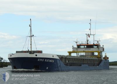
RMS RATINGEN
General Cargo
Current Trip
| Trip Time | 1 day |
|---|---|
| Trip Distance | 312.15 nm |
| AVG Speed | 8.5 Knop |
| MAX Speed | 13.4 Knop |
| Djupgående | 2.5 m |
| AVG Wind | 8.5 knots |
| MAX Wind | 20.8 knots |
| MIN Temp | 2.9°C / 37.22°F |
| MAX Temp | 8.1°C / 46.58°F |
| Position mottagen | 1 m sen |
Current Position
| Longitud | 6.09056° |
|---|---|
| Latitude | 51.85718° |
| Status | Moored |
| Fart | |
| Kurs | 18° |
| Område | North Sea |
| Station | T-AIS |
| Position mottagen | 1 m sen |
Info
Information
The current position of RMS RATINGEN is in North Sea with coordinates 51.85718° / 6.09056° as reported on 2025-02-28 13:19 by AIS to our vessel tracker app. The vessel's current speed is 0 Knop and is currently inside the port of LOBITH.
The vessel RMS RATINGEN (IMO: 9249831, MMSI: 636093015) is a General Cargo that was built in 2002 ( 23 År gammal ). It's sailing under the flag of [LR] Liberia.
In this page you can find informations about the vessels current position, last detected port calls, and current voyage information. If the vessels is not in coverage by AIS you will find the latest position.
The current position of RMS RATINGEN is detected by our AIS receivers and we are not responsible for the reliability of the data. The last position was recorded while the vessel was in Coverage by the Ais receivers of our vessel tracking app.
The current draught of RMS RATINGEN as reported by AIS is 2.5 meters
Weather
| Temperature | 8.2°C / 46.76°F |
|---|---|
| Wind Speed | 10 knots |
| Direction | 7° N |
| Pressure | 1025.5 hPa |
| Humidity | 62.9 % |
| Cloud Coverage | 99 % |
Featured Company
Last Port Calls
| Port | Arrival | Departure | Time In Port |
|---|---|---|---|
| 2025-02-28 07:22 | |||
| 2025-02-23 16:05 | 2025-02-26 15:54 | 2 d | |
| 2025-02-21 18:37 | 2025-02-21 22:14 | 3 h | |
| 2025-02-17 00:52 | 2025-02-21 08:25 | 4 d | |
| 2025-02-04 12:04 | 2025-02-15 07:13 | 10 d | |
| 2025-01-05 08:21 | 2025-02-03 19:52 | 29 d | |
| 2024-12-27 07:35 | 2024-12-27 12:06 | 4 h | |
| 2024-12-23 23:12 | 2024-12-27 03:31 | 3 d | |
| 2024-12-20 17:25 | 2024-12-23 16:41 | 2 d | |
| 2024-12-19 16:18 | 2024-12-20 15:01 | 22 h |
Most Visited Ports (Last year)
| Port | Arrivals | |
|---|---|---|
| 5 | ||
| 5 | ||
| 5 | ||
| 5 | ||
| 4 | ||
| 4 |
Last Trips
| Origin | Departure | Destination | Arrival | Distance | |
|---|---|---|---|---|---|
| 2025-02-26 15:54 | 2025-02-28 08:22 | 312.15 nm | |||
| 2025-02-21 23:14 | 2025-02-23 16:05 | 257.39 nm | |||
| 2025-02-21 09:25 | 2025-02-21 19:37 | 93.53 nm | |||
| 2025-02-15 07:13 | 2025-02-17 01:52 | 347.37 nm | |||
| 2025-02-03 19:52 | 2025-02-04 12:04 | 47.06 nm | |||
| 2024-12-27 13:06 | 2025-01-05 08:21 | 245.12 nm | |||
| 2024-12-27 04:31 | 2024-12-27 08:35 | 35.10 nm | |||
| 2024-12-23 17:41 | 2024-12-24 00:12 | 60.10 nm | |||
| 2024-12-20 16:01 | 2024-12-20 18:25 | 26.15 nm | |||
| 2024-12-19 16:09 | 2024-12-19 17:18 | 5.69 nm |
Events
| Tid | Event | Detaljer | Position / Dest | Information |
|---|---|---|---|---|
| 2025-02-28 07:28 | STOPPAR förflyttning |
51.85711 / 6.09053
[NL] LOBITH
|
Fart: 0.2 kn Kurs: 17° |
|
| 2025-02-28 07:22 | ANLÄNDER HAMN |
|
51.85544 / 6.08939
[NL] LOBITH
|
Fart: 3 kn Kurs: 29° |
| 2025-02-28 07:01 | STARTAR förflyttning | 1.33 nm, East of TOLKAMER |
51.84930 / 6.13959
DESUE
|
Fart: 3.6 kn Kurs: 222° |
| 2025-02-28 06:31 | Status ändrad | Moored Default |
51.85033 / 6.14230
DESUE
|
Fart: Kurs: 46° |
| 2025-02-28 06:28 | Status ändrad | Default Moored |
51.85035 / 6.14231
DESUE
|
Fart: Kurs: 46° |
| 2025-02-28 05:34 | Status ändrad | Moored Default |
51.85033 / 6.14234
DESUE
|
Fart: Kurs: 46° |
| 2025-02-28 05:28 | Status ändrad | Default Moored |
51.85034 / 6.14228
DESUE
|
Fart: Kurs: 46° |
| 2025-02-28 01:44 | Status ändrad | Moored Under way using engine |
51.85036 / 6.14238
DESUE
|
Fart: Kurs: 46° |
| 2025-02-28 01:24 | STOPPAR förflyttning | 1.42 nm, East of TOLKAMER |
51.85027 / 6.14213
DESUE
|
Fart: 0.3 kn Kurs: 47° |
| 2025-02-27 13:48 | ETA ändrat | 2025/02/27 14:30 2025/02/27 13:00 |
52.00445 / 3.94941
DESUE
|
Fart: 11.3 kn Kurs: 103° |