
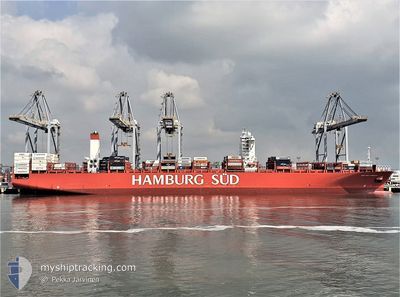
SAN LORENZO MAERSK
Container Ship
Current Trip
BRRIG > BRPNG
| Time Travelled | 22 h, 34 mins |
|---|---|
| Remaining Time | --- |
| Distance Travelled | 149.44 nm |
| Remaining Distance | --- |
| AVG Speed | 9.9 Knop |
| MAX Speed | 14 Knop |
| AVG Wind | 10.3 knots |
| MAX Wind | 15 knots |
| MIN Temp | 22.7°C / 72.86°F |
| MAX Temp | 26.8°C / 80.24°F |
| Djupgående | 10.7 m |
| Position mottagen | 2 d sen |
Current Position
| Longitud | -48.05250° |
|---|---|
| Latitude | -25.92231° |
| Status | Under way using engine |
| Fart | 10.1 Knop |
| Kurs | 352.6° |
| Område | South Atlantic Ocean |
| Station | T-AIS |
| Position mottagen | 2 d sen |
Info
Information
The current position of SAN LORENZO MAERSK is in South Atlantic Ocean with coordinates -25.92231° / -48.05250° as reported on 2025-02-07 07:36 by AIS to our vessel tracker app. The vessel's current speed is 10.1 Knop
The vessel SAN LORENZO MAERSK (IMO: 9622227, MMSI: 219096000) is a Container Ship that was built in 2013 ( 12 År gammal ). It's sailing under the flag of [DK] Denmark.
In this page you can find informations about the vessels current position, last detected port calls, and current voyage information. If the vessels is not in coverage by AIS you will find the latest position.
The current position of SAN LORENZO MAERSK is detected by our AIS receivers and we are not responsible for the reliability of the data. The last position was recorded while the vessel was in Coverage by the Ais receivers of our vessel tracking app.
The current draught of SAN LORENZO MAERSK as reported by AIS is 10.7 meters
Weather
| Temperature | 26.4°C / 79.52°F |
|---|---|
| Wind Speed | 2 knots |
| Direction | 47° NE |
| Pressure | 1016.5 hPa |
| Humidity | 75.1 % |
| Cloud Coverage | 69 % |
Featured Company
Last Port Calls
| Port | Arrival | Departure | Time In Port |
|---|---|---|---|
| 2025-02-07 11:46 | 2025-02-08 11:46 | 23 h | |
| 2025-02-02 12:46 | 2025-02-03 21:58 | 1 d | |
| 2025-01-31 02:50 | 2025-02-01 11:38 | 1 d | |
| 2025-01-27 13:59 | 2025-01-28 05:02 | 15 h | |
| 2025-01-25 14:02 | 2025-01-26 15:59 | 1 d | |
| 2025-01-11 19:48 | 2025-01-12 17:14 | 21 h | |
| 2025-01-07 01:26 | 2025-01-07 20:44 | 19 h | |
| 2024-12-31 19:36 | 2025-01-03 05:26 | 2 d | |
| 2024-12-30 11:56 | 2024-12-31 08:31 | 20 h | |
| 2024-12-28 21:05 | 2024-12-29 14:19 | 17 h |
Most Visited Ports (Last year)
| Port | Arrivals | |
|---|---|---|
| 11 | ||
| 10 | ||
| 6 | ||
| 6 | ||
| 6 | ||
| 6 |
Last Trips
| Origin | Departure | Destination | Arrival | Distance | |
|---|---|---|---|---|---|
| 2025-02-03 18:58 | 2025-02-07 08:46 | 852.04 nm | |||
| 2025-02-01 08:38 | 2025-02-02 09:46 | 141.73 nm | |||
| 2025-01-28 02:02 | 2025-01-30 23:50 | 925.40 nm | |||
| 2025-01-26 12:59 | 2025-01-27 10:59 | 172.91 nm | |||
| 2025-01-12 18:14 | 2025-01-25 11:02 | 4504.63 nm | |||
| 2025-01-07 21:44 | 2025-01-11 20:48 | 1426.06 nm | |||
| 2025-01-03 06:26 | 2025-01-07 02:26 | 459.85 nm | |||
| 2024-12-31 09:31 | 2024-12-31 20:36 | 133.26 nm | |||
| 2024-12-29 15:19 | 2024-12-30 12:56 | 333.95 nm | |||
| 2024-12-12 03:43 | 2024-12-28 22:05 | 5894.42 nm |
Events
| Tid | Event | Detaljer | Position / Dest | Information |
|---|---|---|---|---|
| 2025-02-09 07:52 | STOPPAR förflyttning | 18.23 nm, South East of ITANHAEM |
-24.33702 / -46.50489
BRRIG > BRPNG
|
Fart: 0.2 kn Kurs: 5° |
| 2025-02-08 20:11 | STARTAR förflyttning | 18.29 nm, East of ILHA DO MEL |
-25.53814 / -47.96923
BRRIG > BRPNG
|
Fart: 4.3 kn Kurs: 61° |
| 2025-02-08 18:31 | STOPPAR förflyttning | 18.3 nm, East of ILHA DO MEL |
-25.55784 / -47.96933
BRRIG > BRPNG
|
Fart: 0.2 kn Kurs: 121° |
| 2025-02-08 18:05 | STARTAR förflyttning | 17.77 nm, East of ILHA DO MEL |
-25.55291 / -47.97885
BRRIG > BRPNG
|
Fart: 3.2 kn Kurs: 113° |
| 2025-02-08 15:29 | STOPPAR förflyttning | 16.85 nm, East of ILHA DO MEL |
-25.59166 / -48.00012
BRRIG > BRPNG
|
Fart: 0.2 kn Kurs: 86° |
| 2025-02-08 11:46 | STARTAR förflyttning | 0.89 nm, East of PARANAGUA |
-25.49677 / -48.50172
BRRIG > BRPNG
|
Fart: 4.9 kn Kurs: 75° |
| 2025-02-08 11:46 | AVGÅTT HAMN |
|
-25.49677 / -48.50172
BRRIG > BRPNG
|
Fart: 0.5 kn Kurs: 82° |
| 2025-02-07 11:52 | STOPPAR förflyttning |
-25.49972 / -48.49469
[BR] PARANAGUA
|
Fart: 0.1 kn Kurs: 261° |
|
| 2025-02-07 11:46 | ANLÄNDER HAMN |
|
-25.49936 / -48.49431
[BR] PARANAGUA
|
Fart: 4.6 kn Kurs: 259° |
| 2025-02-07 07:36 | UTANFÖR täckningsområde |
-25.92231 / -48.05250
South Atlantic Ocean
BRRIG > BRPNG
|
Fart: 10.1 kn Kurs: 352.6° |