

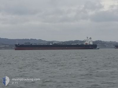
SEA VOYAGER
Crude Oil Tanker

Current Trip
USHOU
| Time Travelled | 2 days |
|---|---|
| Remaining Time | --- |
| Distance Travelled | 762.33 nm |
| Remaining Distance | --- |
| AVG Speed | 11.7 Knop |
| MAX Speed | 15 Knop |
| AVG Wind | 9.3 knots |
| MAX Wind | 15 knots |
| MIN Temp | 27.6°C / 81.68°F |
| MAX Temp | 29.6°C / 85.28°F |
| Djupgående | 8.4 m |
| Position mottagen | 2 d sen |
Current Position
| Longitud | -94.82122° |
|---|---|
| Latitude | 29.40573° |
| Status | Moored |
| Fart | 10 Knop |
| Kurs | 155.9° |
| Område | Gulf of Mexico |
| Station | T-AIS |
| Position mottagen | 2 d sen |
Information
The current position of SEA VOYAGER is in Gulf of Mexico with coordinates 29.40573° / -94.82122° as reported on 2025-06-05 15:56 by AIS to our vessel tracker app. The vessel's current speed is 10 Knop
The vessel SEA VOYAGER (IMO: 9408310, MMSI: 538003439) is a Crude Oil Tanker that was built in 2009 ( 16 År gammal ). It's sailing under the flag of [MH] Marshall Is.
In this page you can find informations about the vessels current position, last detected port calls, and current voyage information. If the vessels is not in coverage by AIS you will find the latest position.
The current position of SEA VOYAGER is detected by our AIS receivers and we are not responsible for the reliability of the data. The last position was recorded while the vessel was in Coverage by the Ais receivers of our vessel tracking app.
The current draught of SEA VOYAGER as reported by AIS is 8.4 meters
Weather
| Temperature | 28.2°C / 82.76°F |
|---|---|
| Wind Speed | 12 knots |
| Direction | 98° E |
| Pressure | 1015.8 hPa |
| Humidity | 75.8 % |
| Cloud Coverage | --- |


Featured Company
Last Port Calls
Last Trips
| Origin | Departure | Destination | Arrival | Distance | |
|---|---|---|---|---|---|
| 2025-05-05 12:09 | 2025-06-03 08:33 | 6616.39 nm | |||
| 2025-04-28 18:19 | 2025-05-05 11:05 | 1265.95 nm | |||
| 2025-04-22 19:40 | 2025-04-27 14:52 | 552.72 nm | |||
| 2025-04-12 06:03 | 2025-04-21 23:55 | 1516.80 nm | |||
| 2025-02-15 07:44 | 2025-04-12 05:03 | 9930.86 nm |
Events
| Tid | Event | Detaljer | Position / Dest | Information |
|---|---|---|---|---|
| 2025-06-05 16:01 | Status ändrad | Default Moored |
29.39315 / -94.81477
USHOU
|
Fart: 10 kn Kurs: 155.9° |
| 2025-06-05 15:56 | UTANFÖR täckningsområde |
29.40573 / -94.82122
Gulf of Mexico
|
Fart: 10 kn Kurs: 155.9° |
|
| 2025-06-05 14:37 | AVGÅTT HAMN |
|
29.59057 / -94.93993
USHOU
|
Fart: 8.9 kn Kurs: 147° |
| 2025-06-05 12:13 | Status ändrad | Moored Default |
29.73620 / -95.12284
[US] HOUSTON
|
Fart: 2.1 kn Kurs: 66° |
| 2025-06-05 12:13 | STARTAR förflyttning |
29.73620 / -95.12284
[US] HOUSTON
|
Fart: 3.1 kn Kurs: 65° |
|
| 2025-06-05 11:56 | I täckningsområde |
29.73635 / -95.12252
Gulf of Mexico
[US] HOUSTON
|
Fart: 3.4 kn Kurs: 62.5° |
|
| 2025-06-04 08:26 | Status ändrad | Default At anchor |
29.73837 / -95.12540
[US] HOUSTON
|
Fart: Kurs: 185° |
| 2025-06-04 08:23 | Status ändrad | At anchor Default |
29.73840 / -95.12547
[US] HOUSTON
|
Fart: Kurs: 185° |
| 2025-06-04 08:23 | UTANFÖR täckningsområde |
29.73840 / -95.12547
Gulf of Mexico
[US] HOUSTON
|
Fart: Kurs: 19.8° |
|
| 2025-06-04 07:50 | Status ändrad | Default At anchor |
29.73841 / -95.12543
[US] HOUSTON
|
Fart: Kurs: 185° |