
SJOHAV
Fishing
Current Trip
95290558/53006236
| Time Travelled | 1 day |
|---|---|
| Remaining Time | --- |
| Distance Travelled | 175.85 nm |
| Remaining Distance | --- |
| AVG Speed | 7.7 Knop |
| MAX Speed | 9.7 Knop |
| AVG Wind | 8.7 knots |
| MAX Wind | 17 knots |
| MIN Temp | -6.1°C / 21.02°F |
| MAX Temp | 1.2°C / 34.16°F |
| Djupgående | 5 m |
| Position mottagen | 3 m sen |
Current Position
| Longitud | 19.57540° |
|---|---|
| Latitude | 69.82307° |
| Status | Under way using engine |
| Fart | 9.4 Knop |
| Kurs | 66° |
| Område | Norwegian Sea |
| Station | T-AIS |
| Position mottagen | 3 m sen |
Info
Information
The current position of SJOHAV is in Norwegian Sea with coordinates 69.82307° / 19.57540° as reported on 2025-02-19 11:38 by AIS to our vessel tracker app. The vessel's current speed is 9.4 Knop
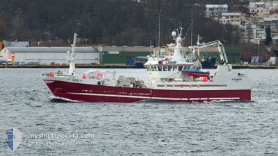
The vessel SJOHAV (IMO: 9025895, MMSI: 257594600) is a Fishing It's sailing under the flag of [NO] Norway.
In this page you can find informations about the vessels current position, last detected port calls, and current voyage information. If the vessels is not in coverage by AIS you will find the latest position.
The current position of SJOHAV is detected by our AIS receivers and we are not responsible for the reliability of the data. The last position was recorded while the vessel was in Coverage by the Ais receivers of our vessel tracking app.
The current draught of SJOHAV as reported by AIS is 5 meters
Weather
| Temperature | -1.6°C / 29.12°F |
|---|---|
| Wind Speed | 9 knots |
| Direction | 236° SW |
| Pressure | 1014.9 hPa |
| Humidity | 93.7 % |
| Cloud Coverage | 100 % |
Featured Company
Last Port Calls
| Port | Arrival | Departure | Time In Port |
|---|---|---|---|
| 2025-02-17 15:49 | 2025-02-18 10:49 | 18 h | |
| 2025-02-16 19:43 | 2025-02-17 13:03 | 17 h | |
| 2025-02-14 17:46 | 2025-02-14 17:59 | 12 m | |
| 2025-02-13 21:47 | 2025-02-14 11:15 | 13 h | |
| 2025-02-13 00:04 | 2025-02-13 09:19 | 9 h | |
| 2025-01-06 16:05 | 2025-02-07 13:42 |
Last Trips
| Origin | Departure | Destination | Arrival | Distance | |
|---|---|---|---|---|---|
| 2025-02-17 14:03 | 2025-02-17 16:49 | 16.63 nm | |||
| 2025-02-14 18:59 | 2025-02-16 20:43 | 437.10 nm | |||
| 2025-02-14 12:15 | 2025-02-14 18:46 | 57.22 nm | |||
| 2025-02-13 10:19 | 2025-02-13 22:47 | 109.52 nm | |||
| 2025-02-07 14:42 | 2025-02-13 01:04 | 70.50 nm | |||
| 2024-11-15 19:04 | 2025-01-06 17:05 | 22.36 nm |
Events
| Tid | Event | Detaljer | Position / Dest | Information |
|---|---|---|---|---|
| 2025-02-19 11:01 | ETA ändrat | 2025/06/07 03:00 |
69.78772 / 19.31555
95290558/53006236
|
Fart: 9.5 kn Kurs: 69° |
| 2025-02-19 10:51 | ETA ändrat | 2025/06/07 03:00 |
69.77697 / 19.24400
95290558/53006236
|
Fart: 9.4 kn Kurs: 57° |
| 2025-02-19 10:48 | ETA ändrat | 2025/06/07 03:00 |
69.77217 / 19.22168
95290558/53006236
|
Fart: 9.6 kn Kurs: 58° |
| 2025-02-19 10:33 | STARTAR förflyttning | 5.88 nm, North East of TROMSO |
69.74772 / 19.14363
95290558/53006236
|
Fart: 3.4 kn Kurs: 49° |
| 2025-02-19 10:19 | ETA ändrat | 2025/06/07 03:00 |
69.75003 / 19.14702
95290558/53006236
|
Fart: 1.7 kn Kurs: 44° |
| 2025-02-19 09:49 | ETA ändrat | 2025/06/07 03:00 |
69.76202 / 19.18207
95290558/53006236
|
Fart: Kurs: 41° |
| 2025-02-19 09:37 | ETA ändrat | 2025/06/07 03:00 |
69.76058 / 19.17910
95290558/53006236
|
Fart: 0.2 kn Kurs: 42° |
| 2025-02-19 09:32 | STOPPAR förflyttning | 6.95 nm, North East of TROMSO |
69.76088 / 19.17850
95290558/53006236
|
Fart: 0.3 kn Kurs: 50° |
| 2025-02-19 09:19 | STARTAR förflyttning | 6.07 nm, North East of TROMSO |
69.75003 / 19.14992
95290558/53006236
|
Fart: 3.3 kn Kurs: 47° |
| 2025-02-19 09:18 | ETA ändrat | 2025/06/07 03:00 |
69.74941 / 19.14818
95290558/53006236
|
Fart: 0.9 kn Kurs: 43° |