
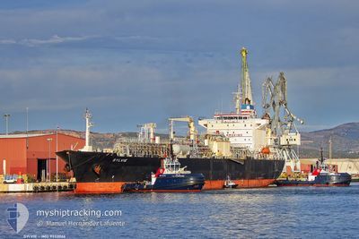
SYLVIE
Lpg Tanker
Current Trip
| Trip Time | 3 days |
|---|---|
| Trip Distance | 359.13 nm |
| AVG Speed | 6 Knop |
| MAX Speed | 6 Knop |
| Djupgående | 9 m |
| AVG Wind | 18.3 knots |
| MAX Wind | 25.8 knots |
| MIN Temp | -2.3°C / 27.86°F |
| MAX Temp | 9.6°C / 49.28°F |
| Position mottagen | 2 d sen |
Current Position
| Longitud | 29.27125° |
|---|---|
| Latitude | 41.49925° |
| Status | Under way using engine |
| Fart | 11.4 Knop |
| Kurs | 14° |
| Område | Black Sea |
| Station | T-AIS |
| Position mottagen | 2 d sen |
Info
Information
The current position of SYLVIE is in Black Sea with coordinates 41.49925° / 29.27125° as reported on 2025-02-06 15:09 by AIS to our vessel tracker app. The vessel's current speed is 11.4 Knop and is currently inside the port of VARNA.
The vessel SYLVIE (IMO: 9332066, MMSI: 477690200) is a Lpg Tanker that was built in 2007 ( 18 År gammal ). It's sailing under the flag of [HK] Hong Kong.
In this page you can find informations about the vessels current position, last detected port calls, and current voyage information. If the vessels is not in coverage by AIS you will find the latest position.
The current position of SYLVIE is detected by our AIS receivers and we are not responsible for the reliability of the data. The last position was recorded while the vessel was in Coverage by the Ais receivers of our vessel tracking app.
The current draught of SYLVIE as reported by AIS is 9 meters
Weather
| Temperature | -1.3°C / 29.66°F |
|---|---|
| Wind Speed | 11 knots |
| Direction | 5° N |
| Pressure | 1037.3 hPa |
| Humidity | 68.9 % |
| Cloud Coverage | 100 % |
Featured Company
Last Port Calls
| Port | Arrival | Departure | Time In Port |
|---|---|---|---|
| 2025-02-07 04:13 | |||
| 2025-02-02 06:52 | 2025-02-03 14:39 | 1 d | |
| 2025-01-27 11:02 | 2025-01-28 07:39 | 20 h | |
| 2025-01-08 18:04 | 2025-01-25 08:51 | 16 d | |
| 2024-12-23 18:58 | 2024-12-24 18:03 | 23 h | |
| 2024-12-18 14:19 | 2024-12-19 19:11 | 1 d | |
| 2024-12-12 18:49 | 2024-12-14 03:39 | 1 d | |
| 2024-12-04 19:43 | 2024-12-06 18:29 | 1 d |
Last Trips
| Origin | Departure | Destination | Arrival | Distance | |
|---|---|---|---|---|---|
| 2025-02-03 17:39 | 2025-02-07 06:13 | 359.13 nm | |||
| 2025-01-28 10:39 | 2025-02-02 09:52 | 158.62 nm | |||
| 2025-01-25 11:51 | 2025-01-27 14:02 | 79.09 nm | |||
| 2024-12-24 18:03 | 2025-01-08 21:04 | 3742.60 nm | |||
| 2024-12-19 20:11 | 2024-12-23 18:58 | 1075.91 nm | |||
| 2024-12-14 04:39 | 2024-12-18 15:19 | 1207.03 nm | |||
| 2024-12-06 21:29 | 2024-12-12 19:49 | 1626.98 nm | |||
| 2024-11-11 16:54 | 2024-12-04 22:43 | 3472.34 nm |
Events
| Tid | Event | Detaljer | Position / Dest | Information |
|---|---|---|---|---|
| 2025-02-07 05:57 | STOPPAR förflyttning |
43.19146 / 27.66292
[BG] VARNA
|
Fart: Kurs: 63° |
|
| 2025-02-07 04:13 | ANLÄNDER HAMN |
|
43.18428 / 27.91690
[BG] VARNA
|
Fart: 8.1 kn Kurs: 262° |
| 2025-02-06 15:15 | Status ändrad | Default Under way using engine |
41.51828 / 29.27742
BGVAR
|
Fart: 11.4 kn Kurs: 14° |
| 2025-02-06 15:09 | UTANFÖR täckningsområde |
41.49925 / 29.27125
Black Sea
BGVAR
|
Fart: 11.4 kn Kurs: 14° |
|
| 2025-02-06 13:16 | Byter havsområde | Turkish part of the Black Sea Turkish part of the Sea of Marmara |
41.23375 / 29.15232
Black Sea
BGVAR
|
Fart: 10.5 kn Kurs: 55° |
| 2025-02-06 09:35 | Destination ändrad | BGVAR TRIST |
40.79198 / 29.04278
BGVAR
|
Fart: 2.3 kn Kurs: 23° |
| 2025-02-06 09:35 | ETA ändrat | 2025/02/06 16:00 2025/02/03 20:00 |
40.79198 / 29.04278
BGVAR
|
Fart: 2.3 kn Kurs: 23° |
| 2025-02-06 02:14 | STARTAR förflyttning | 13.44 nm, West of YALOVA |
40.65892 / 28.98107
TRIST
|
Fart: 3.1 kn Kurs: 291° |
| 2025-02-05 22:32 | STOPPAR förflyttning | 10.43 nm, South West of MALTEPE |
40.77085 / 29.00118
TRIST
|
Fart: 0.3 kn Kurs: 2° |
| 2025-02-05 05:29 | STARTAR förflyttning | 15.71 nm, West of YALOVA |
40.69148 / 28.93330
TRIST
|
Fart: 3.3 kn Kurs: 70° |