
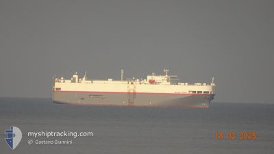
UNITED SPIRIT
Vehicles Carrier
Current Trip
| Time Travelled | 7 days |
|---|---|
| Remaining Time | 1 day |
| Distance Travelled | 2939.73 nm |
| Remaining Distance | 531.93 nm |
| AVG Speed | 15.6 Knop |
| MAX Speed | 18.5 Knop |
| AVG Wind | 15.9 knots |
| MAX Wind | 35 knots |
| MIN Temp | 5°C / 41°F |
| MAX Temp | 18.1°C / 64.58°F |
| Djupgående | 6.9 m |
| Position mottagen | 2 h, 36 m sen |
Current Position
| Longitud | -4.09983° |
|---|---|
| Latitude | 49.34035° |
| Status | Under way using engine |
| Fart | 17.2 Knop |
| Kurs | 57° |
| Område | English Channel |
| Station | T-AIS |
| Position mottagen | 2 h, 36 m sen |
Info
Information
The current position of UNITED SPIRIT is in English Channel with coordinates 49.34035° / -4.09983° as reported on 2025-12-16 01:04 by AIS to our vessel tracker app. The vessel's current speed is 17.2 Knop and is heading at the port of TYNE. The estimated time of arrival as calculated by MyShipTracking vessel tracking app is 2025-12-17 10:32 LT
The vessel UNITED SPIRIT (IMO: 9185047, MMSI: 636011280) is a Vehicles Carrier that was built in 2000 ( 25 År gammal ). It's sailing under the flag of [LR] Liberia.
In this page you can find informations about the vessels current position, last detected port calls, and current voyage information. If the vessels is not in coverage by AIS you will find the latest position.
The current position of UNITED SPIRIT is detected by our AIS receivers and we are not responsible for the reliability of the data. The last position was recorded while the vessel was in Coverage by the Ais receivers of our vessel tracking app.
The current draught of UNITED SPIRIT as reported by AIS is 6.9 meters
Weather
| Temperature | 11.4°C / 52.52°F |
|---|---|
| Wind Speed | 23 knots |
| Direction | 346° NNW |
| Pressure | 1002.7 hPa |
| Humidity | 83.2 % |
| Cloud Coverage | 100 % |
Featured Company
Last Port Calls
| Port | Arrival | Departure | Time In Port |
|---|---|---|---|
| 2025-12-08 08:21 | 2025-12-08 17:18 | 8 h | |
| 2025-11-27 05:19 | 2025-11-28 18:44 | 1 d | |
| 2025-11-23 20:03 | 2025-11-25 21:44 | 2 d | |
| 2025-11-15 11:04 | 2025-11-17 19:45 | 2 d | |
| 2025-11-10 22:30 | 2025-11-11 17:14 | 18 h | |
| 2025-11-06 01:19 | 2025-11-06 02:02 | 43 m | |
| 2025-11-05 13:36 | 2025-11-06 00:29 | 10 h | |
| 2025-11-05 11:59 | 2025-11-05 12:39 | 40 m | |
| 2025-11-02 13:25 | 2025-11-04 15:40 | 2 d | |
| 2025-10-30 04:51 | 2025-10-30 15:21 | 10 h |
Last Trips
| Origin | Departure | Destination | Arrival | Distance | |
|---|---|---|---|---|---|
| 2025-11-28 18:44 | 2025-12-08 11:21 | 3450.43 nm | |||
| 2025-11-25 22:44 | 2025-11-27 05:19 | 427.29 nm | |||
| 2025-11-17 20:45 | 2025-11-23 21:03 | 2136.52 nm | |||
| 2025-11-11 17:14 | 2025-11-15 12:04 | 1234.52 nm | |||
| 2025-11-06 03:02 | 2025-11-10 22:30 | 1244.34 nm | |||
| 2025-11-06 01:29 | 2025-11-06 02:19 | 4.93 nm | |||
| 2025-11-05 13:39 | 2025-11-05 14:36 | 7.22 nm | |||
| 2025-11-04 15:40 | 2025-11-05 12:59 | 286.12 nm | |||
| 2025-10-30 16:21 | 2025-11-02 13:25 | 966.84 nm | |||
| 2025-10-27 07:47 | 2025-10-30 05:51 | 819.87 nm |
Events
| Tid | Event | Detaljer | Position / Dest | Information |
|---|---|---|---|---|
| 2025-12-16 01:12 | Status ändrad | Default Under way using engine |
49.36132 / -4.05103
GBTYN
|
Fart: 17.2 kn Kurs: 57° |
| 2025-12-16 01:04 | UTANFÖR täckningsområde |
49.34035 / -4.09983
English Channel
GBTYN
|
Fart: 17.2 kn Kurs: 57° |
|
| 2025-12-15 23:46 | ETA ändrat | 2025/12/17 14:00 2025/12/17 17:00 |
49.15154 / -4.57638
GBTYN
|
Fart: 16.9 kn Kurs: 62.1° |
| 2025-12-15 23:08 | Upptäckt i hav | French part of the English Channel |
49.07450 / -4.81590
English Channel
GBTYN
|
Fart: 16.6 kn Kurs: 62.7° |
| 2025-12-15 23:04 | Status ändrad | Under way using engine Default |
49.06583 / -4.84391
GBTYN
|
Fart: 16.7 kn Kurs: 65° |
| 2025-12-15 22:48 | Status ändrad | Default Under way using engine |
49.03523 / -4.94334
GBTYN
|
Fart: 16.3 kn Kurs: 66.5° |
| 2025-12-15 22:42 | Status ändrad | Under way using engine Default |
49.02426 / -4.97901
GBTYN
|
Fart: 16.4 kn Kurs: 66° |
| 2025-12-15 22:32 | Status ändrad | Default Under way using engine |
49.00611 / -5.04421
GBTYN
|
Fart: 16.6 kn Kurs: 68.9° |
| 2025-12-15 22:26 | Byter havsområde | French part of the Celtic Sea Portuguese part of the North Atlantic Ocean |
48.99648 / -5.08118
Celtic Sea
GBTYN
|
Fart: 16.6 kn Kurs: 68.9° |
| 2025-12-15 22:26 | Status ändrad | Under way using engine Default |
48.99648 / -5.08118
GBTYN
|
Fart: 16.2 kn Kurs: 71° |