

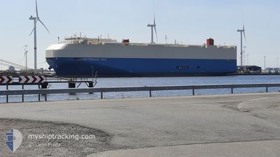
VICTORIOUS ACE
Vehicles Carrier

Current Trip
| Time Travelled | 12 h, 5 mins |
|---|---|
| Remaining Time | 4 days |
| Distance Travelled | 222.23 nm |
| Remaining Distance | 1900.40 nm |
| AVG Speed | 18.1 Knop |
| MAX Speed | 20.3 Knop |
| AVG Wind | 4.9 knots |
| MAX Wind | 7 knots |
| MIN Temp | 31.1°C / 87.98°F |
| MAX Temp | 32.7°C / 90.86°F |
| Djupgående | 7.6 m |
| Position mottagen | 1 m sen |
Current Position
| Longitud | 57.23341° |
|---|---|
| Latitude | 25.33287° |
| Status | Under way using engine |
| Fart | 19.8 Knop |
| Kurs | 130.7° |
| Område | Gulf of Oman |
| Station | T-AIS |
| Position mottagen | 1 m sen |
Information
The current position of VICTORIOUS ACE is in Gulf of Oman with coordinates 25.33287° / 57.23341° as reported on 2025-06-10 11:24 by AIS to our vessel tracker app. The vessel's current speed is 19.8 Knop and is heading at the port of HAMBANTOTA. The estimated time of arrival as calculated by MyShipTracking vessel tracking app is 2025-06-14 18:48 LT
The vessel VICTORIOUS ACE (IMO: 9610406, MMSI: 431605000) is a Vehicles Carrier that was built in 2011 ( 14 År gammal ). It's sailing under the flag of [JP] Japan.
In this page you can find informations about the vessels current position, last detected port calls, and current voyage information. If the vessels is not in coverage by AIS you will find the latest position.
The current position of VICTORIOUS ACE is detected by our AIS receivers and we are not responsible for the reliability of the data. The last position was recorded while the vessel was in Coverage by the Ais receivers of our vessel tracking app.
The current draught of VICTORIOUS ACE as reported by AIS is 7.6 meters
Weather
| Temperature | 32.7°C / 90.86°F |
|---|---|
| Wind Speed | 6 knots |
| Direction | 177° S |
| Pressure | 1002.5 hPa |
| Humidity | 59.6 % |
| Cloud Coverage | --- |


Featured Company
Last Port Calls
| Port | Arrival | Departure | Time In Port |
|---|---|---|---|
| 2025-06-07 02:35 | 2025-06-10 03:20 | 3 d | |
| 2025-06-03 06:36 | 2025-06-04 06:50 | 1 d | |
| 2025-05-31 13:18 | 2025-06-01 15:38 | 1 d | |
| 2025-05-27 06:26 | 2025-05-28 10:49 | 1 d | |
| 2025-05-25 09:56 | 2025-05-25 23:40 | 13 h | |
| 2025-05-04 10:44 | 2025-05-05 00:00 | 13 h | |
| 2025-04-30 11:56 | 2025-05-01 14:40 | 1 d | |
| 2025-04-29 04:38 | 2025-04-29 11:54 | 7 h | |
| 2025-04-27 08:18 | 2025-04-28 10:06 | 1 d | |
| 2025-04-23 06:45 | 2025-04-24 07:44 | 1 d |
Last Trips
| Origin | Departure | Destination | Arrival | Distance | |
|---|---|---|---|---|---|
| 2025-06-04 06:50 | 2025-06-07 02:35 | 984.74 nm | |||
| 2025-06-01 15:38 | 2025-06-03 06:36 | 430.99 nm | |||
| 2025-05-28 10:49 | 2025-05-31 13:18 | 1099.96 nm | |||
| 2025-05-25 23:40 | 2025-05-27 06:26 | 514.51 nm | |||
| 2025-05-05 00:00 | 2025-05-25 09:56 | 8632.16 nm | |||
| 2025-05-01 14:40 | 2025-05-04 10:44 | 1221.62 nm | |||
| 2025-04-29 11:54 | 2025-04-30 11:56 | 331.88 nm | |||
| 2025-04-28 10:06 | 2025-04-29 04:38 | 349.51 nm | |||
| 2025-04-24 07:44 | 2025-04-27 08:18 | 1179.30 nm | |||
| 2025-04-17 16:21 | 2025-04-23 06:45 | 2420.05 nm |
Events
| Tid | Event | Detaljer | Position / Dest | Information |
|---|---|---|---|---|
| 2025-06-10 09:58 | Byter havsområde | Iranian part of the Gulf of Oman Omani part of the Gulf of Oman |
25.64666 / 56.84299
Gulf of Oman
LKHBA
|
Fart: 19 kn Kurs: 156.4° |
| 2025-06-10 09:10 | Byter havsområde | Omani part of the Gulf of Oman Omani part of the Persian Gulf |
25.89651 / 56.83213
Gulf of Oman
LKHBA
|
Fart: 19.4 kn Kurs: 176.8° |
| 2025-06-10 09:10 | Status ändrad | Under way using engine Default |
25.89868 / 56.83199
LKHBA
|
Fart: 19.3 kn Kurs: 176° |
| 2025-06-10 08:51 | I täckningsområde |
25.89651 / 56.83213
Gulf of Oman
LKHBA
|
Fart: 19.4 kn Kurs: 176.8° |
|
| 2025-06-10 04:59 | Status ändrad | Default Under way using engine |
26.25521 / 55.94737
LKHBA
|
Fart: 19.8 kn Kurs: 44.1° |
| 2025-06-10 04:53 | UTANFÖR täckningsområde |
26.23148 / 55.92188
Persian Gulf
LKHBA
|
Fart: 19.8 kn Kurs: 44.1° |
|
| 2025-06-10 04:43 | Byter havsområde | Omani part of the Persian Gulf United Arab Emirates part of the Persian Gulf |
26.19444 / 55.87748
Persian Gulf
LKHBA
|
Fart: 20.2 kn Kurs: 48.4° |
| 2025-06-10 01:12 | STARTAR förflyttning | 19.82 nm, North West of DUBAI |
25.47088 / 54.98386
LKHBA
|
Fart: 14.7 kn Kurs: 32.5° |
| 2025-06-10 01:11 | STOPPAR förflyttning | 19.8 nm, North West of DUBAI |
25.46748 / 54.98146
LKHBA
|
Fart: Kurs: 34° |
| 2025-06-09 23:20 | AVGÅTT HAMN |
|
25.03369 / 55.03520
LKHBA
|
Fart: 8.8 kn Kurs: 322° |