
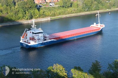
WARBER
General Cargo
Current Trip
| Trip Time | 2 days |
|---|---|
| Trip Distance | 736.26 nm |
| AVG Speed | 11.2 Knop |
| MAX Speed | 13.1 Knop |
| Djupgående | 4 m |
| AVG Wind | 9.9 knots |
| MAX Wind | 21 knots |
| MIN Temp | --- |
| MAX Temp | 4.2°C / 39.56°F |
| Position mottagen | 1 d sen |
Current Position
| Longitud | 27.13851° |
|---|---|
| Latitude | 60.46915° |
| Status | Under way using engine |
| Fart | 9.1 Knop |
| Kurs | 344° |
| Område | Gulf of Finland |
| Station | T-AIS |
| Position mottagen | 1 d sen |
Info
Information
The current position of WARBER is in Gulf of Finland with coordinates 60.46915° / 27.13851° as reported on 2025-03-02 13:32 by AIS to our vessel tracker app. The vessel's current speed is 9.1 Knop and is currently inside the port of HAMINA.
The vessel WARBER (IMO: 9467201, MMSI: 245241000) is a General Cargo that was built in 2010 ( 15 År gammal ). It's sailing under the flag of [NL] Netherlands.
In this page you can find informations about the vessels current position, last detected port calls, and current voyage information. If the vessels is not in coverage by AIS you will find the latest position.
The current position of WARBER is detected by our AIS receivers and we are not responsible for the reliability of the data. The last position was recorded while the vessel was in Coverage by the Ais receivers of our vessel tracking app.
The current draught of WARBER as reported by AIS is 4 meters
Weather
| Temperature | 0.9°C / 33.62°F |
|---|---|
| Wind Speed | 12 knots |
| Direction | 264° W |
| Pressure | 997.8 hPa |
| Humidity | 90.4 % |
| Cloud Coverage | 87 % |
Featured Company
Last Port Calls
| Port | Arrival | Departure | Time In Port |
|---|---|---|---|
| 2025-03-02 15:53 | |||
| 2025-02-26 00:46 | 2025-02-27 17:51 | 1 d | |
| 2025-02-23 10:22 | 2025-02-24 06:34 | 20 h | |
| 2025-02-22 06:57 | 2025-02-22 07:44 | 46 m | |
| 2025-02-20 02:19 | 2025-02-22 02:25 | 2 d | |
| 2025-02-19 21:25 | 2025-02-19 21:44 | 19 m | |
| 2025-02-13 17:11 | 2025-02-14 08:19 | 15 h | |
| 2025-02-10 17:56 | 2025-02-11 18:19 | 1 d | |
| 2025-02-06 15:32 | 2025-02-07 03:26 | 11 h | |
| 2025-02-03 19:44 | 2025-02-06 00:26 | 2 d |
Last Trips
| Origin | Departure | Destination | Arrival | Distance | |
|---|---|---|---|---|---|
| 2025-02-27 17:51 | 2025-03-02 15:53 | 736.26 nm | |||
| 2025-02-24 06:34 | 2025-02-26 00:46 | 432.62 nm | |||
| 2025-02-22 07:44 | 2025-02-23 10:22 | 246.15 nm | |||
| 2025-02-22 02:25 | 2025-02-22 06:57 | 49.06 nm | |||
| 2025-02-19 21:44 | 2025-02-20 02:19 | 49.21 nm | |||
| 2025-02-14 08:19 | 2025-02-19 21:25 | 1382.18 nm | |||
| 2025-02-11 18:19 | 2025-02-13 17:11 | 420.09 nm | |||
| 2025-02-07 03:26 | 2025-02-10 17:56 | 751.08 nm | |||
| 2025-02-06 00:26 | 2025-02-06 15:32 | 166.36 nm | |||
| 2025-01-31 12:09 | 2025-02-03 19:44 | 882.40 nm |
Events
| Tid | Event | Detaljer | Position / Dest | Information |
|---|---|---|---|---|
| 2025-03-02 14:14 | STOPPAR förflyttning |
60.53401 / 27.17090
[FI] HAMINA
|
Fart: Kurs: 352° |
|
| 2025-03-02 13:53 | ANLÄNDER HAMN |
|
60.52390 / 27.18661
[FI] HAMINA
|
Fart: 11.1 kn Kurs: 45° |
| 2025-03-02 13:38 | Status ändrad | Default Under way using engine |
60.48327 / 27.13464
HAMINA
|
Fart: 9.1 kn Kurs: 344° |
| 2025-03-02 13:32 | UTANFÖR täckningsområde |
60.46915 / 27.13851
Gulf of Finland
[FI] HAMINA
|
Fart: 9.1 kn Kurs: 344° |
|
| 2025-03-02 09:27 | Djupgående ändrat | 4 3.8 |
60.06287 / 26.20706
HAMINA
|
Fart: 10.2 kn Kurs: 34.7° |
| 2025-03-02 09:25 | Status ändrad | Under way using engine Default |
60.05852 / 26.20109
HAMINA
|
Fart: 10.1 kn Kurs: 33° |
| 2025-03-02 09:25 | I täckningsområde |
60.06005 / 26.20324
Gulf of Finland
HAMINA
|
Fart: 10.2 kn Kurs: 35.3° |
|
| 2025-03-02 07:46 | Status ändrad | Default Under way using engine |
59.88350 / 25.81623
HAMINA
|
Fart: 9.5 kn Kurs: 69.9° |
| 2025-03-02 07:40 | UTANFÖR täckningsområde |
59.87770 / 25.78875
Gulf of Finland
HAMINA
|
Fart: 9.5 kn Kurs: 69.9° |
|
| 2025-03-02 07:28 | Byter havsområde | Finnish part of the Gulf of Finland Estonian part of the Gulf of Finland |
59.87126 / 25.72827
Gulf of Finland
HAMINA
|
Fart: 9.6 kn Kurs: 77.2° |