
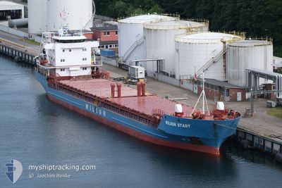
WILSON STADT
General Cargo
Current Trip
| Trip Time | 6 days |
|---|---|
| Trip Distance | 1542.28 nm |
| AVG Speed | 9.3 Knop |
| MAX Speed | 12.2 Knop |
| Djupgående | 6.7 m |
| AVG Wind | 17.5 knots |
| MAX Wind | 25.5 knots |
| MIN Temp | -5°C / 23°F |
| MAX Temp | 10.5°C / 50.9°F |
| Position mottagen | 1 m sen |
Current Position
| Longitud | 9.87871° |
|---|---|
| Latitude | 63.32084° |
| Status | Moored |
| Fart | |
| Kurs | 238° |
| Område | Norwegian Sea |
| Station | T-AIS |
| Position mottagen | 1 m sen |
Info
Information
The current position of WILSON STADT is in Norwegian Sea with coordinates 63.32084° / 9.87871° as reported on 2025-02-14 20:39 by AIS to our vessel tracker app. The vessel's current speed is 0 Knop and is currently inside the port of ORKANGER.
The vessel WILSON STADT (IMO: 8918485, MMSI: 257683000) is a General Cargo that was built in 2000 ( 25 År gammal ). It's sailing under the flag of [NO] Norway.
In this page you can find informations about the vessels current position, last detected port calls, and current voyage information. If the vessels is not in coverage by AIS you will find the latest position.
The current position of WILSON STADT is detected by our AIS receivers and we are not responsible for the reliability of the data. The last position was recorded while the vessel was in Coverage by the Ais receivers of our vessel tracking app.
The current draught of WILSON STADT as reported by AIS is 6.7 meters
Weather
| Temperature | -3.9°C / 24.98°F |
|---|---|
| Wind Speed | 3 knots |
| Direction | 279° W |
| Pressure | 1025.2 hPa |
| Humidity | 96.5 % |
| Cloud Coverage | 100 % |
Featured Company
Last Port Calls
| Port | Arrival | Departure | Time In Port |
|---|---|---|---|
| 2025-02-14 16:45 | |||
| 2025-02-07 06:08 | 2025-02-07 17:55 | 11 h | |
| 2025-02-01 13:43 | 2025-02-03 22:14 | 2 d | |
| 2025-01-30 09:53 | 2025-01-30 12:05 | 2 h | |
| 2025-01-25 09:11 | 2025-01-28 14:12 | 3 d | |
| 2025-01-22 06:23 | 2025-01-24 17:56 | 2 d | |
| 2025-01-16 21:19 | 2025-01-18 16:24 | 1 d | |
| 2025-01-12 10:59 | 2025-01-15 11:25 | 3 d | |
| 2024-12-26 17:13 | 2024-12-28 18:10 | 2 d | |
| 2024-12-14 10:47 | 2024-12-18 16:58 | 4 d |
Last Trips
| Origin | Departure | Destination | Arrival | Distance | |
|---|---|---|---|---|---|
| 2025-02-07 18:55 | 2025-02-14 17:45 | 1542.28 nm | |||
| 2025-02-03 23:14 | 2025-02-07 07:08 | 802.40 nm | |||
| 2025-01-30 13:05 | 2025-02-01 14:43 | 402.17 nm | |||
| 2025-01-28 16:12 | 2025-01-30 10:53 | 411.88 nm | |||
| 2025-01-24 18:56 | 2025-01-25 11:11 | 143.87 nm | |||
| 2025-01-18 16:24 | 2025-01-22 07:23 | 888.48 nm | |||
| 2025-01-15 12:25 | 2025-01-16 21:19 | 352.48 nm | |||
| 2024-12-28 19:10 | 2025-01-12 11:59 | 2227.74 nm | |||
| 2024-12-18 17:58 | 2024-12-26 18:13 | 1675.86 nm | |||
| 2024-12-11 22:46 | 2024-12-14 11:47 | 188.57 nm |
Events
| Tid | Event | Detaljer | Position / Dest | Information |
|---|---|---|---|---|
| 2025-02-14 17:21 | Status ändrad | Moored Under way using engine |
63.32090 / 9.87871
[NO] ORKANGER
|
Fart: Kurs: 238° |
| 2025-02-14 16:58 | STOPPAR förflyttning |
63.32115 / 9.87857
[NO] ORKANGER
|
Fart: 0.1 kn Kurs: 236° |
|
| 2025-02-14 16:45 | ANLÄNDER HAMN |
|
63.32536 / 9.88304
[NO] ORKANGER
|
Fart: 2.8 kn Kurs: 197° |
| 2025-02-14 12:32 | Status ändrad | Under way using engine Default |
63.49553 / 9.07049
ESLCG>NOTHA
|
Fart: 11.1 kn Kurs: 69° |
| 2025-02-14 11:47 | Status ändrad | Default Under way using engine |
63.44439 / 8.77548
ESLCG>NOTHA
|
Fart: 10.9 kn Kurs: 69.9° |
| 2025-02-14 11:14 | Status ändrad | Under way using engine Default |
63.40766 / 8.56021
ESLCG>NOTHA
|
Fart: 11.2 kn Kurs: 65° |
| 2025-02-14 10:36 | Status ändrad | Default Under way using engine |
63.34516 / 8.34515
ESLCG>NOTHA
|
Fart: 11.6 kn Kurs: 44.3° |
| 2025-02-13 13:09 | Byter havsområde | Norwegian part of the Norwegian Sea United Kingdom part of the Inner Seas off the West Coast of Scotland |
61.86090 / 1.86346
Norwegian Sea
ESLCG>NOTHA
|
Fart: 7.8 kn Kurs: 61.8° |
| 2025-02-13 13:09 | Status ändrad | Under way using engine Default |
61.86090 / 1.86346
ESLCG>NOTHA
|
Fart: 7.6 kn Kurs: 67° |
| 2025-02-13 13:02 | I täckningsområde |
61.86090 / 1.86346
Norwegian Sea
ESLCG>NOTHA
|
Fart: 7.8 kn Kurs: 61.8° |