
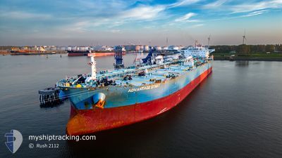
ADVANTAGE START
Crude Oil Tanker
Current Trip
| Time Travelled | 12 days |
|---|---|
| Remaining Time | --- |
| Distance Travelled | 654.14 nm |
| Remaining Distance | 2.69 nm |
| AVG Speed | 7.4 Knots |
| MAX Speed | 14.2 Knots |
| AVG Wind | 25 knots |
| MAX Wind | 36 knots |
| MIN Temp | -0.3°C / 31.46°F |
| MAX Temp | 17.5°C / 63.5°F |
| Draught | 10.8 m |
| Position Received | 2 m ago |
Current Position
| Longitude | 29.67858° |
|---|---|
| Latitude | 40.75719° |
| Status | At anchor |
| Speed | 0.3 Knots |
| Course | 224° |
| Area | Sea of Marmara |
| Station | T-AIS |
| Position Received | 2 m ago |
Info
Information
The current position of ADVANTAGE START is in Sea of Marmara with coordinates 40.75719° / 29.67858° as reported on 2026-01-10 14:05 by AIS to our vessel tracker app. The vessel's current speed is 0.3 Knots and is heading at the port of KORFEZ. The estimated time of arrival as calculated by MyShipTracking vessel tracking app is 2026-01-08 03:01 LT
The vessel ADVANTAGE START (IMO: 9466570, MMSI: 538006196) is a Crude Oil Tanker that was built in 2011 ( 15 years old ). It's sailing under the flag of [MH] Marshall Is.
In this page you can find informations about the vessels current position, last detected port calls, and current voyage information. If the vessels is not in coverage by AIS you will find the latest position.
The current position of ADVANTAGE START is detected by our AIS receivers and we are not responsible for the reliability of the data. The last position was recorded while the vessel was in Coverage by the Ais receivers of our vessel tracking app.
The current draught of ADVANTAGE START as reported by AIS is 10.8 meters
Weather
| Temperature | 13.5°C / 56.3°F |
|---|---|
| Wind Speed | 8 knots |
| Direction | 215° SW |
| Pressure | 1001.6 hPa |
| Humidity | 65.1 % |
| Cloud Coverage | 22 % |
Featured Company
Last Port Calls
| Port | Arrival | Departure | Time In Port |
|---|---|---|---|
| 2025-12-27 04:32 | 2025-12-29 07:42 | 2 d | |
| 2025-11-09 02:11 | 2025-11-11 08:53 | 2 d |
Last Trips
| Origin | Departure | Destination | Arrival | Distance | |
|---|---|---|---|---|---|
| 2025-11-11 08:53 | 2025-12-27 04:32 | 9907.94 nm | |||
| 2025-10-18 10:45 | 2025-11-09 02:11 | 3295.22 nm |
Events
| Time | Event | Details | Position / Dest | Info |
|---|---|---|---|---|
| 2026-01-10 01:11 | Status Changed | At anchor Default |
40.75612 / 29.67981
TRTUT
|
Speed: 0.4 kn Course: 264° |
| 2026-01-10 01:08 | Status Changed | Default At anchor |
40.75567 / 29.67996
TRTUT
|
Speed: 0.4 kn Course: 269° |
| 2026-01-08 23:35 | Status Changed | At anchor Default |
40.75339 / 29.67972
TRTUT
|
Speed: Course: 308° |
| 2026-01-08 23:32 | Status Changed | Default At anchor |
40.75337 / 29.67966
TRTUT
|
Speed: Course: 309° |
| 2026-01-08 22:08 | Status Changed | At anchor Default |
40.75425 / 29.68029
TRTUT
|
Speed: Course: 281° |
| 2026-01-08 21:59 | Status Changed | Default At anchor |
40.75421 / 29.68038
TRTUT
|
Speed: Course: 285° |
| 2026-01-08 21:23 | Status Changed | At anchor Default |
40.75451 / 29.68047
TRTUT
|
Speed: 0.2 kn Course: 283° |
| 2026-01-08 21:20 | Status Changed | Default At anchor |
40.75437 / 29.68043
TRTUT
|
Speed: 0.2 kn Course: 294° |
| 2026-01-08 10:50 | Status Changed | At anchor Default |
40.75803 / 29.67748
TRTUT
|
Speed: 0.4 kn Course: 193° |
| 2026-01-08 10:46 | Status Changed | Default At anchor |
40.75806 / 29.67697
TRTUT
|
Speed: 0.4 kn Course: 184° |