
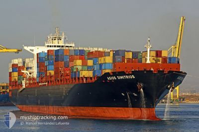
AGIOS DIMITRIOS
Container Ship
Current Trip
| Time Travelled | 9 h, 58 mins |
|---|---|
| Remaining Time | 7 days |
| Distance Travelled | 107.42 nm |
| Remaining Distance | 3564.73 nm |
| AVG Speed | 16.4 Knots |
| MAX Speed | 20.1 Knots |
| AVG Wind | 14.7 knots |
| MAX Wind | 19 knots |
| MIN Temp | 13.5°C / 56.3°F |
| MAX Temp | 23.1°C / 73.58°F |
| Draught | 10 m |
| Position Received | 7 h, 29 m ago |
Current Position
| Longitude | -79.25925° |
|---|---|
| Latitude | 32.58437° |
| Status | Under way using engine |
| Speed | 19.2 Knots |
| Course | 92.8° |
| Area | North Atlantic Ocean |
| Station | T-AIS |
| Position Received | 7 h, 29 m ago |
Info
Information
The current position of AGIOS DIMITRIOS is in North Atlantic Ocean with coordinates 32.58437° / -79.25925° as reported on 2025-02-07 04:32 by AIS to our vessel tracker app. The vessel's current speed is 19.2 Knots and is heading at the port of LE HAVRE. The estimated time of arrival as calculated by MyShipTracking vessel tracking app is 2025-02-14 23:54 LT
The vessel AGIOS DIMITRIOS (IMO: 9349605, MMSI: 636015975) is a Container Ship that was built in 2011 ( 14 years old ). It's sailing under the flag of [LR] Liberia.
In this page you can find informations about the vessels current position, last detected port calls, and current voyage information. If the vessels is not in coverage by AIS you will find the latest position.
The current position of AGIOS DIMITRIOS is detected by our AIS receivers and we are not responsible for the reliability of the data. The last position was recorded while the vessel was in Coverage by the Ais receivers of our vessel tracking app.
The current draught of AGIOS DIMITRIOS as reported by AIS is 10 meters
Weather
| Temperature | 23.7°C / 74.66°F |
|---|---|
| Wind Speed | 19 knots |
| Direction | 256° WSW |
| Pressure | 1018.5 hPa |
| Humidity | 75.8 % |
| Cloud Coverage | 17 % |
Featured Company
Last Port Calls
| Port | Arrival | Departure | Time In Port |
|---|---|---|---|
| 2025-02-05 20:22 | 2025-02-07 02:04 | 1 d | |
| 2025-02-04 05:31 | 2025-02-04 17:19 | 11 h | |
| 2025-01-31 19:23 | 2025-02-01 06:39 | 11 h | |
| 2025-01-27 14:34 | 2025-01-28 06:59 | 16 h | |
| 2025-01-23 20:12 | 2025-01-25 23:01 | 2 d | |
| 2025-01-12 00:33 | 2025-01-13 00:16 | 23 h | |
| 2025-01-10 05:34 | 2025-01-11 05:24 | 23 h | |
| 2025-01-07 18:00 | 2025-01-09 19:42 | 2 d | |
| 2024-12-21 07:24 | 2024-12-22 02:31 | 19 h | |
| 2024-12-17 11:07 | 2024-12-18 00:39 | 13 h |
Most Visited Ports (Last year)
| Port | Arrivals | |
|---|---|---|
| 5 | ||
| 4 | ||
| 3 | ||
| 3 | ||
| 3 | ||
| 3 |
Last Trips
| Origin | Departure | Destination | Arrival | Distance | |
|---|---|---|---|---|---|
| 2025-02-04 12:19 | 2025-02-05 15:22 | 404.02 nm | |||
| 2025-02-01 00:39 | 2025-02-04 00:31 | 817.06 nm | |||
| 2025-01-28 01:59 | 2025-01-31 13:23 | 1152.37 nm | |||
| 2025-01-25 18:01 | 2025-01-27 09:34 | 642.14 nm | |||
| 2025-01-13 01:16 | 2025-01-23 15:12 | 4346.18 nm | |||
| 2025-01-11 06:24 | 2025-01-12 01:33 | 278.56 nm | |||
| 2025-01-09 20:42 | 2025-01-10 06:34 | 124.71 nm | |||
| 2024-12-21 21:31 | 2025-01-07 19:00 | 4406.61 nm | |||
| 2024-12-17 19:39 | 2024-12-21 02:24 | 416.22 nm | |||
| 2024-12-15 06:46 | 2024-12-17 06:07 | 771.98 nm |
Events
| Time | Event | Details | Position / Dest | Info |
|---|---|---|---|---|
| 2025-02-07 04:39 | Status Changed | Default Under way using engine |
32.58282 / -79.21552
FRLEH
|
Speed: 19.2 kn Course: 92.8° |
| 2025-02-07 04:32 | Status Changed | Under way using engine Default |
32.58437 / -79.25925
FRLEH
|
Speed: 19.2 kn Course: 92° |
| 2025-02-07 04:32 | OUT of Coverage |
32.58437 / -79.25925
North Atlantic Ocean
FRLEH
|
Speed: 19.2 kn Course: 92.8° |
|
| 2025-02-07 04:31 | Status Changed | Default Under way using engine |
32.58462 / -79.26560
FRLEH
|
Speed: 19.2 kn Course: 91.4° |
| 2025-02-07 04:19 | Status Changed | Under way using engine Default |
32.58650 / -79.34194
FRLEH
|
Speed: 18.2 kn Course: 90° |
| 2025-02-07 04:07 | Status Changed | Default Under way using engine |
32.58684 / -79.41106
FRLEH
|
Speed: 9.5 kn Course: 87° |
| 2025-02-07 03:59 | Status Changed | Under way using engine Default |
32.58577 / -79.44290
FRLEH
|
Speed: 9.5 kn Course: 85° |
| 2025-02-07 03:55 | Status Changed | Default Under way using engine |
32.58528 / -79.45415
FRLEH
|
Speed: 8.5 kn Course: 87.1° |
| 2025-02-07 03:48 | Status Changed | Under way using engine Default |
32.58436 / -79.47622
FRLEH
|
Speed: 10.6 kn Course: 99° |
| 2025-02-07 03:39 | Status Changed | Default Under way using engine |
32.58743 / -79.50301
FRLEH
|
Speed: 8.1 kn Course: 97.6° |