

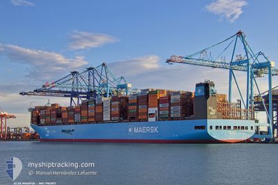
ALVA MAERSK
Cargo

Current Trip
| Time Travelled | 7 h, 57 mins |
|---|---|
| Remaining Time | --- |
| Distance Travelled | 82.75 nm |
| Remaining Distance | --- |
| AVG Speed | 12.3 Knots |
| MAX Speed | 16.7 Knots |
| AVG Wind | 6.5 knots |
| MAX Wind | 11.3 knots |
| MIN Temp | 29.4°C / 84.92°F |
| MAX Temp | 30.9°C / 87.62°F |
| Draught | 11.4 m |
| Position Received | 2 h, 11 m ago |
Current Position
| Longitude | 104.87351° |
|---|---|
| Latitude | 1.87775° |
| Status | Under way using engine |
| Speed | 16.7 Knots |
| Course | 15.1° |
| Area | South China Sea |
| Station | T-AIS |
| Position Received | 2 h, 11 m ago |
Information
The current position of ALVA MAERSK is in South China Sea with coordinates 1.87775° / 104.87351° as reported on 2025-06-02 13:23 by AIS to our vessel tracker app. The vessel's current speed is 16.7 Knots
The vessel ALVA MAERSK (IMO: 9961817, MMSI: 219734000) is a Cargo It's sailing under the flag of [DK] Denmark.
In this page you can find informations about the vessels current position, last detected port calls, and current voyage information. If the vessels is not in coverage by AIS you will find the latest position.
The current position of ALVA MAERSK is detected by our AIS receivers and we are not responsible for the reliability of the data. The last position was recorded while the vessel was in Coverage by the Ais receivers of our vessel tracking app.
The current draught of ALVA MAERSK as reported by AIS is 11.4 meters
Weather
| Temperature | 29.4°C / 84.92°F |
|---|---|
| Wind Speed | 11 knots |
| Direction | 153° SSE |
| Pressure | 1009.6 hPa |
| Humidity | 80.3 % |
| Cloud Coverage | 93 % |


Featured Company
Last Port Calls
| Port | Arrival | Departure | Time In Port |
|---|---|---|---|
| 2025-06-01 07:53 | 2025-06-02 15:38 | 1 d | |
| 2025-05-02 11:14 | 2025-05-03 20:26 | 1 d | |
| 2025-04-29 06:00 | 2025-05-01 03:03 | 1 d | |
| 2025-04-27 11:15 | 2025-04-28 22:32 | 1 d | |
| 2025-04-23 07:54 | 2025-04-24 16:07 | 1 d | |
| 2025-04-20 01:08 | 2025-04-22 03:04 | 2 d |
Last Trips
| Origin | Departure | Destination | Arrival | Distance | |
|---|---|---|---|---|---|
| 2025-05-03 20:26 | 2025-06-01 07:53 | 11150.67 nm | |||
| 2025-05-01 03:03 | 2025-05-02 11:14 | 63.00 nm | |||
| 2025-04-28 22:32 | 2025-04-29 06:00 | 69.77 nm | |||
| 2025-04-24 16:07 | 2025-04-27 11:15 | 412.79 nm | |||
| 2025-04-22 03:04 | 2025-04-23 07:54 | 173.83 nm | |||
| 2025-03-23 00:18 | 2025-04-20 01:08 | 6820.71 nm |
Events
| Time | Event | Details | Position / Dest | Info |
|---|---|---|---|---|
| 2025-06-02 13:23 | OUT of Coverage |
1.87775 / 104.87351
South China Sea
SGSIN>CNYSA
|
Speed: 16.7 kn Course: 15.1° |
|
| 2025-06-02 13:23 | Detected in Sea | Malaysian part of the South China Sea |
1.87775 / 104.87351
South China Sea
SGSIN>CNYSA
|
Speed: 16.7 kn Course: 15.1° |
| 2025-06-02 13:23 | IN Coverage |
1.87775 / 104.87351
South China Sea
SGSIN>CNYSA
|
Speed: 16.7 kn Course: 15.1° |
|
| 2025-06-02 09:50 | OUT of Coverage |
1.25588 / 104.18014
Singapore Strait
SGSIN>CNYSA
|
Speed: 16.8 kn Course: 82.6° |
|
| 2025-06-02 08:40 | Change Sea Area | Indonesian part of the Singapore Strait Singaporean part of the Singapore Strait |
1.20035 / 103.87052
Singapore Strait
SGSIN>CNYSA
|
Speed: 13.7 kn Course: 69.9° |
| 2025-06-02 07:56 | Status Changed | Under way using engine Moored |
1.22951 / 103.78505
SGSIN>CNYSA
|
Speed: 9 kn Course: 139.8° |
| 2025-06-02 07:38 | PORT DEPARTURE |
|
1.26096 / 103.77137
SGSIN>CNYSA
|
Speed: 6.6 kn Course: 210° |
| 2025-06-02 07:33 | START Moving |
1.26701 / 103.77532
[SG] SINGAPORE
|
Speed: 3.1 kn Course: 218° |
|
| 2025-06-02 06:33 | Draught Changed | 11.4 11.6 |
1.27400 / 103.77431
[SG] SINGAPORE
|
Speed: Course: 31° |
| 2025-06-02 06:33 | ETA Changed | 2025/06/08 00:30 2025/06/07 23:59 |
1.27400 / 103.77431
[SG] SINGAPORE
|
Speed: Course: 31° |