

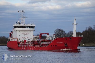
AMAZONITH
Tanker

Current Trip
IT AUG
| Time Travelled | 1 day |
|---|---|
| Remaining Time | --- |
| Distance Travelled | 246.66 nm |
| Remaining Distance | --- |
| AVG Speed | 9.1 Knots |
| MAX Speed | 10.6 Knots |
| AVG Wind | 12.6 knots |
| MAX Wind | 18.8 knots |
| MIN Temp | 17.8°C / 64.04°F |
| MAX Temp | 21.3°C / 70.34°F |
| Draught | 5 m |
| Position Received | 10 h, 56 m ago |
Current Position
| Longitude | 12.26555° |
|---|---|
| Latitude | 37.46277° |
| Status | Under way using engine |
| Speed | 9 Knots |
| Course | 304° |
| Area | Mediterranean Sea - Eastern Basin |
| Station | T-AIS |
| Position Received | 10 h, 56 m ago |
Information
The current position of AMAZONITH is in Mediterranean Sea - Eastern Basin with coordinates 37.46277° / 12.26555° as reported on 2025-05-17 14:38 by AIS to our vessel tracker app. The vessel's current speed is 9 Knots
The vessel AMAZONITH (MMSI: 210688000) is a Tanker It's sailing under the flag of [CY] Cyprus.
In this page you can find informations about the vessels current position, last detected port calls, and current voyage information. If the vessels is not in coverage by AIS you will find the latest position.
The current position of AMAZONITH is detected by our AIS receivers and we are not responsible for the reliability of the data. The last position was recorded while the vessel was in Coverage by the Ais receivers of our vessel tracking app.
The current draught of AMAZONITH as reported by AIS is 5 meters
Weather
| Temperature | 18.7°C / 65.66°F |
|---|---|
| Wind Speed | 11 knots |
| Direction | 227° SW |
| Pressure | 1018.5 hPa |
| Humidity | 80.6 % |
| Cloud Coverage | --- |


Featured Company
Last Port Calls
| Port | Arrival | Departure | Time In Port |
|---|---|---|---|
| 2025-05-14 07:22 | 2025-05-16 17:54 | 2 d | |
| 2025-05-11 08:56 | 2025-05-11 23:03 | 14 h | |
| 2025-05-06 07:10 | 2025-05-08 22:09 | 2 d | |
| 2025-05-03 16:46 | 2025-05-04 11:09 | 18 h | |
| 2025-05-01 13:06 | 2025-05-02 10:01 | 20 h | |
| 2025-04-28 07:34 | 2025-04-29 15:06 | 1 d | |
| 2025-04-25 08:02 | 2025-04-27 18:18 | 2 d | |
| 2025-04-22 14:28 | 2025-04-23 16:32 | 1 d | |
| 2025-04-20 09:58 | 2025-04-21 08:33 | 22 h | |
| 2025-04-16 07:18 | 2025-04-17 15:10 | 1 d |
Last Trips
| Origin | Departure | Destination | Arrival | Distance | |
|---|---|---|---|---|---|
| 2025-05-11 23:03 | 2025-05-14 07:22 | 510.25 nm | |||
| 2025-05-08 22:09 | 2025-05-11 08:56 | 519.32 nm | |||
| 2025-05-04 11:09 | 2025-05-06 07:10 | 388.99 nm | |||
| 2025-05-02 10:01 | 2025-05-03 16:46 | 316.73 nm | |||
| 2025-04-29 15:06 | 2025-05-01 13:06 | 501.25 nm | |||
| 2025-04-27 18:18 | 2025-04-28 07:34 | 91.18 nm | |||
| 2025-04-23 16:32 | 2025-04-25 08:02 | 388.13 nm | |||
| 2025-04-21 08:33 | 2025-04-22 14:28 | 321.13 nm | |||
| 2025-04-17 15:10 | 2025-04-20 09:58 | 512.79 nm | |||
| 2025-04-15 16:03 | 2025-04-16 07:18 | 95.21 nm |
Events
| Time | Event | Details | Position / Dest | Info |
|---|---|---|---|---|
| 2025-05-17 14:50 | Status Changed | Default Under way using engine |
37.48012 / 12.23437
IT AUG
|
Speed: 9 kn Course: 304° |
| 2025-05-17 14:38 | OUT of Coverage |
37.46277 / 12.26555
Mediterranean Sea - Eastern Basin
|
Speed: 9 kn Course: 304° |
|
| 2025-05-17 14:32 | Status Changed | Under way using engine Default |
37.45415 / 12.28133
IT AUG
|
Speed: 9.1 kn Course: 304° |
| 2025-05-17 14:18 | IN Coverage |
37.45464 / 12.28040
Mediterranean Sea - Eastern Basin
|
Speed: 8.8 kn Course: 303° |
|
| 2025-05-17 03:43 | Status Changed | Default Under way using engine |
36.71275 / 14.01525
IT AUG
|
Speed: 9.3 kn Course: 299° |
| 2025-05-17 03:33 | Status Changed | Under way using engine Default |
36.70072 / 14.04145
IT AUG
|
Speed: 9 kn Course: 299° |
| 2025-05-17 03:33 | OUT of Coverage |
36.70072 / 14.04145
Mediterranean Sea - Eastern Basin
|
Speed: 9.3 kn Course: 299° |
|
| 2025-05-17 03:16 | Status Changed | Default Under way using engine |
36.67870 / 14.09012
IT AUG
|
Speed: 9.1 kn Course: 299° |
| 2025-05-17 02:47 | Detected in Sea | Italian part of the Mediterranean Sea - Eastern Basin |
36.64220 / 14.17089
Mediterranean Sea - Eastern Basin
|
Speed: 9.2 kn Course: 299° |
| 2025-05-17 02:44 | Status Changed | Under way using engine Default |
36.63832 / 14.17928
IT AUG
|
Speed: 9.3 kn Course: 299° |