
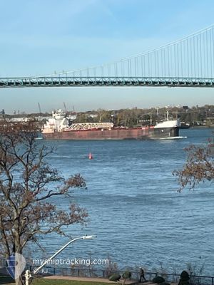
AMERICAN COURAGE
Self Discharging Bulk Carrier
Current Trip
| Time Travelled | 1 day |
|---|---|
| Remaining Time | --- |
| Distance Travelled | 237.39 nm |
| Remaining Distance | --- |
| AVG Speed | 10.7 Knots |
| MAX Speed | 13.6 Knots |
| AVG Wind | 7.1 knots |
| MAX Wind | 11.8 knots |
| MIN Temp | 7°C / 44.6°F |
| MAX Temp | 21.6°C / 70.88°F |
| Draught | 0 m |
| Position Received | 14 h, 42 m ago |
Current Position
| Longitude | -82.95577° |
|---|---|
| Latitude | 44.80436° |
| Status | Under way using engine |
| Speed | 13.4 Knots |
| Course | 341.8° |
| Area | --- |
| Station | T-AIS |
| Position Received | 14 h, 42 m ago |
Information
The current position of AMERICAN COURAGE is in --- with coordinates 44.80436° / -82.95577° as reported on 2025-06-09 13:53 by AIS to our vessel tracker app. The vessel's current speed is 13.4 Knots
The vessel AMERICAN COURAGE (IMO: 7634226, MMSI: 367121040) is a Self Discharging Bulk Carrier that was built in 1979 ( 46 years old ). It's sailing under the flag of [US] USA.
In this page you can find informations about the vessels current position, last detected port calls, and current voyage information. If the vessels is not in coverage by AIS you will find the latest position.
The current position of AMERICAN COURAGE is detected by our AIS receivers and we are not responsible for the reliability of the data. The last position was recorded while the vessel was in Coverage by the Ais receivers of our vessel tracking app.
Weather
| Temperature | 9.8°C / 49.64°F |
|---|---|
| Wind Speed | 10 knots |
| Direction | 223° SW |
| Pressure | 1002 hPa |
| Humidity | 91.7 % |
| Cloud Coverage | 77 % |
Featured Company
Last Port Calls
| Port | Arrival | Departure | Time In Port |
|---|---|---|---|
| 2025-06-08 21:47 | 2025-06-09 00:21 | 2 h | |
| 2025-06-07 17:28 | 2025-06-08 04:20 | 10 h | |
| 2025-06-05 19:46 | 2025-06-07 01:15 | 1 d | |
| 2025-06-03 17:06 | 2025-06-04 10:24 | 17 h | |
| 2025-06-02 09:20 | 2025-06-02 10:27 | 1 h | |
| 2025-06-01 11:24 | 2025-06-01 14:02 | 2 h | |
| 2025-05-31 21:44 | 2025-06-01 02:55 | 5 h | |
| 2025-05-30 11:42 | 2025-05-30 12:58 | 1 h | |
| 2025-05-29 14:51 | 2025-05-30 06:43 | 15 h | |
| 2025-05-28 17:48 | 2025-05-29 01:03 | 7 h |
Most Visited Ports (Last year)
| Port | Arrivals | |
|---|---|---|
| 108 | ||
| 25 | ||
| 16 | ||
| 7 | ||
| 7 | ||
| 6 |
Last Trips
| Origin | Departure | Destination | Arrival | Distance | |
|---|---|---|---|---|---|
| 2025-06-08 00:20 | 2025-06-08 17:47 | 99.88 nm | |||
| 2025-06-06 21:15 | 2025-06-07 13:28 | 93.42 nm | |||
| 2025-06-04 06:24 | 2025-06-05 15:46 | 399.00 nm | |||
| 2025-06-02 06:27 | 2025-06-03 13:06 | 173.48 nm | |||
| 2025-06-01 10:02 | 2025-06-02 05:20 | 202.47 nm | |||
| 2025-05-31 22:55 | 2025-06-01 07:24 | 92.09 nm | |||
| 2025-05-30 08:58 | 2025-05-31 17:44 | 6.64 nm | |||
| 2025-05-30 02:43 | 2025-05-30 07:42 | 44.53 nm | |||
| 2025-05-28 21:03 | 2025-05-29 10:51 | 48.27 nm | |||
| 2025-05-22 18:27 | 2025-05-28 13:48 | 899.24 nm |
Events
| Time | Event | Details | Position / Dest | Info |
|---|---|---|---|---|
| 2025-06-10 01:40 | START Moving | 4.02 nm, South East of PRESQUE ISLE |
45.29543 / -83.41595
STONEPORT
|
Speed: 3.1 kn Course: 107° |
| 2025-06-09 17:17 | STOP Moving | 3.87 nm, South East of PRESQUE ISLE |
45.29641 / -83.41959
STONEPORT
|
Speed: 0.1 kn Course: 309° |
| 2025-06-09 14:01 | Status Changed | Default Under way using engine |
44.83115 / -82.96777
STONEPORT
|
Speed: 13.4 kn Course: 341.8° |
| 2025-06-09 13:53 | OUT of Coverage |
44.80436 / -82.95577
STONEPORT
|
Speed: 13.4 kn Course: 341.8° |
|
| 2025-06-09 12:45 | Status Changed | Under way using engine Default |
44.56309 / -82.84718
STONEPORT
|
Speed: 13.2 kn Course: 342° |
| 2025-06-09 12:41 | Status Changed | Default Under way using engine |
44.54920 / -82.84087
STONEPORT
|
Speed: 13.2 kn Course: 342° |
| 2025-06-09 09:56 | Status Changed | Under way using engine Default |
43.97732 / -82.58618
STONEPORT
|
Speed: 13 kn Course: 343° |
| 2025-06-09 09:53 | Status Changed | Default Under way using engine |
43.96637 / -82.58135
STONEPORT
|
Speed: 12.9 kn Course: 342.2° |
| 2025-06-09 09:45 | Status Changed | Under way using engine Default |
43.94104 / -82.57024
STONEPORT
|
Speed: 12.9 kn Course: 342° |
| 2025-06-09 09:29 | IN Coverage |
43.94512 / -82.57203
STONEPORT
|
Speed: 12.9 kn Course: 342.2° |