
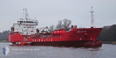
AMULETH
Tanker C
Current Trip
| Time Travelled | 1 day |
|---|---|
| Remaining Time | 1 day |
| Distance Travelled | 306.74 nm |
| Remaining Distance | 494.17 nm |
| AVG Speed | 12.2 Knots |
| MAX Speed | 14.7 Knots |
| AVG Wind | 7 knots |
| MAX Wind | 13 knots |
| MIN Temp | 1.5°C / 34.7°F |
| MAX Temp | 5.2°C / 41.36°F |
| Draught | 6.1 m |
| Position Received | 2 m ago |
Current Position
| Longitude | 8.40370° |
|---|---|
| Latitude | 53.98179° |
| Status | Under way using engine |
| Speed | 12.2 Knots |
| Course | 102.7° |
| Area | North Sea |
| Station | T-AIS |
| Position Received | 2 m ago |
Info
Information
The current position of AMULETH is in North Sea with coordinates 53.98179° / 8.40370° as reported on 2025-02-03 11:03 by AIS to our vessel tracker app. The vessel's current speed is 12.2 Knots and is heading at the port of KLAIPEDA. The estimated time of arrival as calculated by MyShipTracking vessel tracking app is 2025-02-05 06:18 LT
The vessel AMULETH (IMO: 9778002, MMSI: 209066000) is a Tanker C It's sailing under the flag of [CY] Cyprus.
In this page you can find informations about the vessels current position, last detected port calls, and current voyage information. If the vessels is not in coverage by AIS you will find the latest position.
The current position of AMULETH is detected by our AIS receivers and we are not responsible for the reliability of the data. The last position was recorded while the vessel was in Coverage by the Ais receivers of our vessel tracking app.
The current draught of AMULETH as reported by AIS is 6.1 meters
Weather
| Temperature | 2°C / 35.6°F |
|---|---|
| Wind Speed | 11 knots |
| Direction | 198° SSW |
| Pressure | 1026.8 hPa |
| Humidity | 72.9 % |
| Cloud Coverage | 83 % |
Featured Company
Last Port Calls
| Port | Arrival | Departure | Time In Port |
|---|---|---|---|
| 2025-01-31 22:29 | 2025-02-02 09:08 | 1 d | |
| 2025-01-18 17:12 | 2025-01-19 17:45 | 1 d | |
| 2025-01-16 00:55 | 2025-01-17 03:12 | 1 d | |
| 2025-01-11 10:26 | 2025-01-13 05:44 | 1 d | |
| 2025-01-02 13:41 | 2025-01-04 14:52 | 2 d | |
| 2024-12-28 20:32 | 2024-12-29 15:14 | 18 h | |
| 2024-12-22 07:47 | 2024-12-23 07:04 | 23 h | |
| 2024-12-17 18:03 | 2024-12-20 04:38 | 2 d | |
| 2024-12-13 09:12 | 2024-12-14 13:29 | 1 d | |
| 2024-12-06 14:40 | 2024-12-10 17:30 | 4 d |
Last Trips
| Origin | Departure | Destination | Arrival | Distance | |
|---|---|---|---|---|---|
| 2025-01-19 18:45 | 2025-01-31 23:29 | 1943.61 nm | |||
| 2025-01-17 03:12 | 2025-01-18 18:12 | 391.63 nm | |||
| 2025-01-13 06:44 | 2025-01-16 00:55 | 382.18 nm | |||
| 2025-01-04 15:52 | 2025-01-11 11:26 | 450.68 nm | |||
| 2024-12-29 15:14 | 2025-01-02 14:41 | 981.82 nm | |||
| 2024-12-23 08:04 | 2024-12-28 20:32 | 1489.29 nm | |||
| 2024-12-20 05:38 | 2024-12-22 08:47 | 501.39 nm | |||
| 2024-12-14 14:29 | 2024-12-17 19:03 | 182.28 nm | |||
| 2024-12-10 17:30 | 2024-12-13 10:12 | 646.40 nm | |||
| 2024-11-29 09:03 | 2024-12-06 14:40 | 198.47 nm |
Events
| Time | Event | Details | Position / Dest | Info |
|---|---|---|---|---|
| 2025-02-03 10:48 | Status Changed | Under way using engine Default |
53.99207 / 8.31235
LT KLJ
|
Speed: 13.3 kn Course: 91° |
| 2025-02-03 10:45 | Status Changed | Default Under way using engine |
53.99281 / 8.29750
LT KLJ
|
Speed: 10.5 kn Course: 87.6° |
| 2025-02-03 04:50 | Status Changed | Under way using engine Default |
53.77233 / 6.53744
LT KLJ
|
Speed: 10.6 kn Course: 79° |
| 2025-02-03 04:49 | Status Changed | Default Under way using engine |
53.77183 / 6.53322
LT KLJ
|
Speed: 10.5 kn Course: 77.9° |
| 2025-02-03 04:25 | Change Sea Area | German part of the North Sea Dutch part of the North Sea |
53.75706 / 6.41552
North Sea
LT KLJ
|
Speed: 10.8 kn Course: 77° |
| 2025-02-03 04:25 | Status Changed | Under way using engine Default |
53.75671 / 6.41297
LT KLJ
|
Speed: 10.7 kn Course: 77° |
| 2025-02-03 04:08 | IN Coverage |
53.75706 / 6.41552
North Sea
LT KLJ
|
Speed: 10.8 kn Course: 77° |
|
| 2025-02-03 03:11 | Status Changed | Default Under way using engine |
53.68767 / 6.04938
LT KLJ
|
Speed: 11.6 kn Course: 71.2° |
| 2025-02-03 02:57 | OUT of Coverage |
53.67325 / 5.97951
North Sea
LT KLJ
|
Speed: 11.6 kn Course: 71.2° |
|
| 2025-02-02 22:15 | Status Changed | Under way using engine Default |
53.27040 / 4.61684
LT KLJ
|
Speed: 13 kn Course: 33° |