
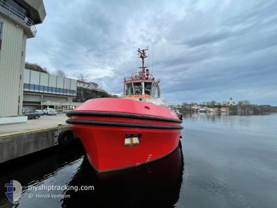
BAMSE
Tug
Current Trip
GRENLAND
| Time Travelled | 11 mins |
|---|---|
| Remaining Time | --- |
| Distance Travelled | 0.25 nm |
| Remaining Distance | --- |
| AVG Speed | --- |
| MAX Speed | --- |
| AVG Wind | 3 knots |
| MAX Wind | 3 knots |
| MIN Temp | -5.3°C / 22.46°F |
| MAX Temp | -5.3°C / 22.46°F |
| Draught | 6.4 m |
| Position Received | 3 m ago |
Current Position
| Longitude | 9.61252° |
|---|---|
| Latitude | 59.12023° |
| Status | Moored |
| Speed | 1.5 Knots |
| Course | 204° |
| Area | Skaggerak |
| Station | T-AIS |
| Position Received | 3 m ago |
Info
Information
The current position of BAMSE is in Skaggerak with coordinates 59.12023° / 9.61252° as reported on 2025-02-12 20:13 by AIS to our vessel tracker app. The vessel's current speed is 1.5 Knots
The vessel BAMSE (IMO: 9873929, MMSI: 259001680) is a Tug It's sailing under the flag of [NO] Norway.
In this page you can find informations about the vessels current position, last detected port calls, and current voyage information. If the vessels is not in coverage by AIS you will find the latest position.
The current position of BAMSE is detected by our AIS receivers and we are not responsible for the reliability of the data. The last position was recorded while the vessel was in Coverage by the Ais receivers of our vessel tracking app.
The current draught of BAMSE as reported by AIS is 6.4 meters
Weather
| Temperature | -5.3°C / 22.46°F |
|---|---|
| Wind Speed | 3 knots |
| Direction | 356° N |
| Pressure | 1029.9 hPa |
| Humidity | 95.3 % |
| Cloud Coverage | 18 % |
Featured Company
Last Port Calls
| Port | Arrival | Departure | Time In Port |
|---|---|---|---|
| 2025-02-12 20:30 | 2025-02-12 21:05 | 35 m | |
| 2025-02-12 07:44 | 2025-02-12 08:36 | 52 m | |
| 2025-02-12 00:25 | 2025-02-12 00:35 | 10 m | |
| 2025-02-11 20:06 | 2025-02-11 22:55 | 2 h | |
| 2025-02-11 18:47 | 2025-02-11 18:59 | 12 m | |
| 2025-02-11 00:47 | 2025-02-11 18:18 | 17 h | |
| 2025-02-10 22:00 | 2025-02-10 23:24 | 1 h | |
| 2025-02-10 18:45 | 2025-02-10 19:05 | 19 m | |
| 2025-02-10 15:04 | 2025-02-10 15:28 | 23 m | |
| 2025-02-10 07:34 | 2025-02-10 08:05 | 30 m |
Last Trips
| Origin | Departure | Destination | Arrival | Distance | |
|---|---|---|---|---|---|
| 2025-02-12 08:36 | 2025-02-12 20:30 | 2.45 nm | |||
| 2025-02-12 00:35 | 2025-02-12 07:44 | 5.12 nm | |||
| 2025-02-11 22:55 | 2025-02-12 00:25 | 10.33 nm | |||
| 2025-02-11 18:59 | 2025-02-11 20:06 | 10.26 nm | |||
| 2025-02-11 18:18 | 2025-02-11 18:47 | 4.05 nm | |||
| 2025-02-10 23:24 | 2025-02-11 00:47 | 11.59 nm | |||
| 2025-02-10 19:05 | 2025-02-10 22:00 | 3.77 nm | |||
| 2025-02-10 15:28 | 2025-02-10 18:45 | 20.47 nm | |||
| 2025-02-10 08:05 | 2025-02-10 15:04 | 2.86 nm | |||
| 2025-02-10 07:23 | 2025-02-10 07:34 | 0.90 nm |
Events
| Time | Event | Details | Position / Dest | Info |
|---|---|---|---|---|
| 2025-02-12 20:05 | PORT DEPARTURE |
|
59.11755 / 9.61040
GRENLAND
|
Speed: 2 kn Course: 119° |
| 2025-02-12 19:32 | STOP Moving |
59.11719 / 9.61980
[NO] PORSGRUNN
|
Speed: Course: 11° |
|
| 2025-02-12 19:30 | PORT ARRIVAL |
|
59.11713 / 9.61989
[NO] PORSGRUNN
|
Speed: 6 kn Course: 320.2° |
| 2025-02-12 19:24 | START Moving | 0.91 nm, South East of PORSGRUNN |
59.10926 / 9.63567
GRENLAND
|
Speed: 9.3 kn Course: 307.5° |
| 2025-02-12 17:04 | STOP Moving | 1.15 nm, South East of PORSGRUNN |
59.10798 / 9.64347
GRENLAND
|
Speed: Course: 43° |
| 2025-02-12 16:52 | START Moving | 0.83 nm, South East of PORSGRUNN |
59.10962 / 9.63262
GRENLAND
|
Speed: 10 kn Course: 293.7° |
| 2025-02-12 07:45 | STOP Moving | 1.15 nm, South East of PORSGRUNN |
59.10798 / 9.64345
GRENLAND
|
Speed: Course: 42° |
| 2025-02-12 07:37 | START Moving | 0.69 nm, South East of PORSGRUNN |
59.11150 / 9.63003
GRENLAND
|
Speed: 6.3 kn Course: 137° |
| 2025-02-12 07:36 | PORT DEPARTURE |
|
59.11150 / 9.63003
GRENLAND
|
Speed: 3.7 kn Course: 150° |
| 2025-02-12 06:44 | STOP Moving |
59.11482 / 9.62787
[NO] PORSGRUNN
|
Speed: 0.1 kn Course: 22° |