
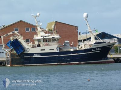
BIRGITTE L349
Fishing
Current Trip
Unknown
| Time Travelled | 2 days |
|---|---|
| Remaining Time | --- |
| Distance Travelled | 269.61 nm |
| Remaining Distance | --- |
| AVG Speed | 7 Knots |
| MAX Speed | 9.8 Knots |
| AVG Wind | 25.1 knots |
| MAX Wind | 33 knots |
| MIN Temp | 7.7°C / 45.86°F |
| MAX Temp | 10.6°C / 51.08°F |
| Draught | 0 m |
| Position Received | 2 m ago |
Current Position
| Longitude | 2.41355° |
|---|---|
| Latitude | 59.30377° |
| Status | Engaged in Fishing |
| Speed | 3.1 Knots |
| Course | 45° |
| Area | North Sea |
| Station | T-AIS |
| Position Received | 2 m ago |
Info
Information
The current position of BIRGITTE L349 is in North Sea with coordinates 59.30377° / 2.41355° as reported on 2025-12-14 16:06 by AIS to our vessel tracker app. The vessel's current speed is 3.1 Knots
The vessel BIRGITTE L349 (MMSI: 219024698) is a Fishing It's sailing under the flag of [DK] Denmark.
In this page you can find informations about the vessels current position, last detected port calls, and current voyage information. If the vessels is not in coverage by AIS you will find the latest position.
The current position of BIRGITTE L349 is detected by our AIS receivers and we are not responsible for the reliability of the data. The last position was recorded while the vessel was in Coverage by the Ais receivers of our vessel tracking app.
Weather
| Temperature | 10°C / 50°F |
|---|---|
| Wind Speed | 22 knots |
| Direction | 185° S |
| Pressure | 998.4 hPa |
| Humidity | 95 % |
| Cloud Coverage | 94 % |
Featured Company
Last Port Calls
| Port | Arrival | Departure | Time In Port |
|---|---|---|---|
| 2025-12-12 13:22 | |||
| 2025-11-06 00:17 | 2025-11-06 13:24 | 13 h | |
| 2025-10-26 22:52 | 2025-10-27 15:18 | 16 h | |
| 2025-10-16 19:10 | 2025-10-18 09:28 | 1 d | |
| 2025-10-09 16:00 | 2025-10-10 21:39 | 1 d | |
| 2025-10-08 17:06 | 2025-10-09 14:47 | 21 h | |
| 2025-10-08 15:15 |
Most Visited Ports (Last year)
| Port | Arrivals | |
|---|---|---|
| 22 | ||
| 1 | ||
| 1 |
Last Trips
| Origin | Departure | Destination | Arrival | Distance | |
|---|---|---|---|---|---|
| 2025-10-27 16:18 | 2025-11-06 01:17 | 879.90 nm | |||
| 2025-10-18 11:28 | 2025-10-26 23:52 | 638.23 nm | |||
| 2025-10-10 23:39 | 2025-10-16 21:10 | 544.14 nm | |||
| 2025-10-09 16:47 | 2025-10-09 18:00 | 12.15 nm | |||
| 2025-10-08 17:15 | 2025-10-08 19:06 | 17.82 nm |
Events
| Time | Event | Details | Position / Dest | Info |
|---|---|---|---|---|
| 2025-12-14 13:21 | OUT of Coverage |
59.30212 / 2.39401
North Sea
|
Speed: 3 kn Course: 231.4° |
|
| 2025-12-14 13:21 | IN Coverage |
59.30212 / 2.39401
North Sea
|
Speed: 3 kn Course: 231.4° |
|
| 2025-12-14 11:54 | OUT of Coverage |
59.35834 / 2.48930
North Sea
|
Speed: 2.9 kn Course: 218.5° |
|
| 2025-12-13 16:28 | IN Coverage |
58.69818 / 3.69782
North Sea
|
Speed: 0.7 kn Course: 13.1° |
|
| 2025-12-13 10:28 | OUT of Coverage |
58.45468 / 3.91704
North Sea
|
Speed: 2.7 kn Course: 321.3° |
|
| 2025-12-12 19:01 | Detected in Sea | Norwegian part of the North Sea |
57.19928 / 7.00775
North Sea
|
Speed: 8.7 kn Course: 307° |
| 2025-12-12 18:02 | IN Coverage |
57.11415 / 7.21960
North Sea
|
Speed: 8.7 kn Course: 306.5° |
|
| 2025-12-12 16:44 | OUT of Coverage |
57.00012 / 7.50290
North Sea
|
Speed: 8.9 kn Course: 307.1° |
|
| 2025-12-12 13:35 | IN Coverage |
56.72326 / 8.18806
North Sea
|
Speed: 9.5 kn Course: 299.9° |
|
| 2025-12-12 13:22 | PORT DEPARTURE |
|
56.72326 / 8.18806
|
Speed: Course: 70° |