
BORE SONG
Ro-Ro Cargo
Current Trip
| Time Travelled | 7 h, 24 mins |
|---|---|
| Remaining Time | 26 mins |
| Distance Travelled | 113.45 nm |
| Remaining Distance | 10.21 nm |
| AVG Speed | 15.7 Knots |
| MAX Speed | 17.7 Knots |
| AVG Wind | 4.8 knots |
| MAX Wind | 18 knots |
| MIN Temp | 6.3°C / 43.34°F |
| MAX Temp | 9.2°C / 48.56°F |
| Draught | 6.2 m |
| Position Received | 1 m ago |
Current Position
| Longitude | -5.99489° |
|---|---|
| Latitude | 53.36096° |
| Status | Under way using engine |
| Speed | 11.4 Knots |
| Course | 247° |
| Area | Irish Sea and St. George's Channel |
| Station | T-AIS |
| Position Received | 1 m ago |
Info
Information
The current position of BORE SONG is in Irish Sea and St. George's Channel with coordinates 53.36096° / -5.99489° as reported on 2025-02-03 00:57 by AIS to our vessel tracker app. The vessel's current speed is 11.4 Knots and is heading at the port of DUBLIN. The estimated time of arrival as calculated by MyShipTracking vessel tracking app is 2025-02-03 01:24 LT
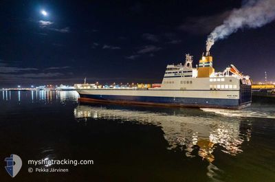
The vessel BORE SONG (IMO: 9443566, MMSI: 244130690) is a Ro-Ro Cargo that was built in 2011 ( 14 years old ). It's sailing under the flag of [NL] Netherlands.
In this page you can find informations about the vessels current position, last detected port calls, and current voyage information. If the vessels is not in coverage by AIS you will find the latest position.
The current position of BORE SONG is detected by our AIS receivers and we are not responsible for the reliability of the data. The last position was recorded while the vessel was in Coverage by the Ais receivers of our vessel tracking app.
The current draught of BORE SONG as reported by AIS is 6.2 meters
Weather
| Temperature | 7.4°C / 45.32°F |
|---|---|
| Wind Speed | 7 knots |
| Direction | 188° S |
| Pressure | 1019.4 hPa |
| Humidity | 78.1 % |
| Cloud Coverage | 71 % |
Featured Company
Last Port Calls
| Port | Arrival | Departure | Time In Port |
|---|---|---|---|
| 2025-02-01 13:42 | 2025-02-02 17:34 | 1 d | |
| 2025-02-01 02:29 | 2025-02-01 06:51 | 4 h | |
| 2025-01-31 14:58 | 2025-01-31 19:20 | 4 h | |
| 2025-01-31 03:16 | 2025-01-31 08:08 | 4 h | |
| 2025-01-30 14:49 | 2025-01-30 19:56 | 5 h | |
| 2025-01-30 03:14 | 2025-01-30 07:57 | 4 h | |
| 2025-01-29 14:54 | 2025-01-29 20:08 | 5 h | |
| 2025-01-29 02:20 | 2025-01-29 07:58 | 5 h | |
| 2025-01-28 14:35 | 2025-01-28 19:04 | 4 h | |
| 2025-01-28 01:31 | 2025-01-28 06:53 | 5 h |
Most Visited Ports (Last year)
| Port | Arrivals | |
|---|---|---|
| 258 | ||
| 244 | ||
| 8 | ||
| 6 | ||
| 3 | ||
| 2 |
Last Trips
| Origin | Departure | Destination | Arrival | Distance | |
|---|---|---|---|---|---|
| 2025-02-01 06:51 | 2025-02-01 13:42 | 120.26 nm | |||
| 2025-01-31 19:20 | 2025-02-01 02:29 | 120.86 nm | |||
| 2025-01-31 08:08 | 2025-01-31 14:58 | 120.57 nm | |||
| 2025-01-30 19:56 | 2025-01-31 03:16 | 120.76 nm | |||
| 2025-01-30 07:57 | 2025-01-30 14:49 | 120.74 nm | |||
| 2025-01-29 20:08 | 2025-01-30 03:14 | 120.64 nm | |||
| 2025-01-29 07:58 | 2025-01-29 14:54 | 119.71 nm | |||
| 2025-01-28 19:04 | 2025-01-29 02:20 | 120.70 nm | |||
| 2025-01-28 06:53 | 2025-01-28 14:35 | 121.31 nm | |||
| 2025-01-27 17:34 | 2025-01-28 01:31 | 120.79 nm |
Events
| Time | Event | Details | Position / Dest | Info |
|---|---|---|---|---|
| 2025-02-02 23:17 | Change Sea Area | Irish part of the Irish Sea and St. George's Channel United Kingdom part of the Irish Sea and St. George's Channel |
53.49625 / -5.32120
Irish Sea and St. George's Channel
DUBLIN <-> LIVERPOOL
|
Speed: 15.4 kn Course: 260.8° |
| 2025-02-02 22:50 | Status Changed | Under way using engine Default |
53.51438 / -5.13467
DUBLIN <-> LIVERPOOL
|
Speed: 14.8 kn Course: 259° |
| 2025-02-02 22:47 | Status Changed | Default Under way using engine |
53.51665 / -5.11583
DUBLIN <-> LIVERPOOL
|
Speed: 14.7 kn Course: 259.6° |
| 2025-02-02 22:39 | Status Changed | Under way using engine Default |
53.52314 / -5.05854
DUBLIN <-> LIVERPOOL
|
Speed: 14.4 kn Course: 259° |
| 2025-02-02 22:19 | IN Coverage |
53.52314 / -5.05854
Irish Sea and St. George's Channel
DUBLIN <-> LIVERPOOL
|
Speed: 14.7 kn Course: 259.6° |
|
| 2025-02-02 21:35 | Status Changed | Default Under way using engine |
53.56336 / -4.64798
DUBLIN <-> LIVERPOOL
|
Speed: 14.1 kn Course: 263.4° |
| 2025-02-02 21:27 | OUT of Coverage |
53.56704 / -4.58999
Irish Sea and St. George's Channel
DUBLIN <-> LIVERPOOL
|
Speed: 14.1 kn Course: 263.4° |
|
| 2025-02-02 21:25 | Status Changed | Under way using engine Default |
53.56778 / -4.57946
DUBLIN <-> LIVERPOOL
|
Speed: 13.9 kn Course: 263° |
| 2025-02-02 21:07 | IN Coverage |
53.56704 / -4.58999
Irish Sea and St. George's Channel
DUBLIN <-> LIVERPOOL
|
Speed: 14.1 kn Course: 263.4° |
|
| 2025-02-02 20:12 | OUT of Coverage |
53.56559 / -4.03516
Irish Sea and St. George's Channel
DUBLIN <-> LIVERPOOL
|
Speed: 17.6 kn Course: 270° |