

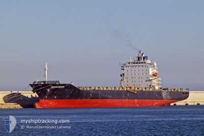
BOSTON
Container Ship

Current Trip
GNCKY
| Time Travelled | 5 days |
|---|---|
| Remaining Time | --- |
| Distance Travelled | 736.37 nm |
| Remaining Distance | --- |
| AVG Speed | 12.5 Knots |
| MAX Speed | 15.9 Knots |
| AVG Wind | 10.4 knots |
| MAX Wind | 14 knots |
| MIN Temp | 25.3°C / 77.54°F |
| MAX Temp | 28.4°C / 83.12°F |
| Draught | 12.2 m |
| Position Received | 2025-04-01 17:22 |
Current Position
| Longitude | -13.72335° |
|---|---|
| Latitude | 9.50971° |
| Status | Moored |
| Speed | |
| Course | 31° |
| Area | North Atlantic Ocean |
| Station | T-AIS |
| Position Received | 2025-04-01 17:22 |
Information
The current position of BOSTON is in North Atlantic Ocean with coordinates 9.50971° / -13.72335° as reported on 2025-04-01 17:22 by AIS to our vessel tracker app. The vessel's current speed is 0 Knots
The vessel BOSTON (IMO: 9315355, MMSI: 538009604) is a Container Ship that was built in 2007 ( 18 years old ). It's sailing under the flag of [MH] Marshall Is.
In this page you can find informations about the vessels current position, last detected port calls, and current voyage information. If the vessels is not in coverage by AIS you will find the latest position.
The current position of BOSTON is detected by our AIS receivers and we are not responsible for the reliability of the data. The last position was recorded while the vessel was in Coverage by the Ais receivers of our vessel tracking app.
The current draught of BOSTON as reported by AIS is 12.2 meters
Weather
| Temperature | 27.4°C / 81.32°F |
|---|---|
| Wind Speed | 4 knots |
| Direction | 145° SE |
| Pressure | 1012.2 hPa |
| Humidity | 75.9 % |
| Cloud Coverage | 69 % |


Featured Company
Last Port Calls
| Port | Arrival | Departure | Time In Port |
|---|---|---|---|
| 2025-05-17 12:46 | 2025-05-18 04:06 | 15 h | |
| 2025-05-15 12:40 | 2025-05-16 01:08 | 12 h | |
| 2025-05-06 22:40 | 2025-05-08 03:44 | 1 d | |
| 2025-05-03 17:27 | 2025-05-05 09:21 | 1 d | |
| 2025-04-22 07:24 | 2025-04-23 13:44 | 1 d | |
| 2025-04-17 18:22 | 2025-04-20 09:25 | 2 d | |
| 2025-04-08 18:52 | 2025-04-09 10:16 | 15 h | |
| 2025-04-01 10:11 | 2025-04-03 21:27 | 2 d | |
| 2025-03-21 01:34 | 2025-03-22 07:32 | 1 d | |
| 2025-03-08 13:45 | 2025-03-10 19:27 | 2 d |
Last Trips
| Origin | Departure | Destination | Arrival | Distance | |
|---|---|---|---|---|---|
| 2025-05-16 01:08 | 2025-05-17 12:46 | 480.23 nm | |||
| 2025-05-08 03:44 | 2025-05-15 12:40 | 1590.36 nm | |||
| 2025-05-05 09:21 | 2025-05-06 22:40 | 525.77 nm | |||
| 2025-04-23 13:44 | 2025-05-03 17:27 | 2574.40 nm | |||
| 2025-04-20 09:25 | 2025-04-22 07:24 | 542.29 nm | |||
| 2025-04-09 10:16 | 2025-04-17 18:22 | 1468.66 nm | |||
| 2025-04-03 21:27 | 2025-04-08 18:52 | 1003.89 nm | |||
| 2025-03-22 07:32 | 2025-04-01 10:11 | 2222.09 nm | |||
| 2025-03-10 19:27 | 2025-03-21 01:34 | 2150.22 nm | |||
| 2025-03-07 15:58 | 2025-03-08 13:45 | 120.20 nm |
Events
| Time | Event | Details | Position / Dest | Info |
|---|---|---|---|---|
| 2025-05-21 10:00 | START Moving | 1.45 nm, South West of TEMA |
5.61382 / -.00410
GNCKY
|
Speed: 3.1 kn Course: 78° |
| 2025-05-18 23:15 | STOP Moving | 1.82 nm, South West of TEMA |
5.61361 / -.01161
GNCKY
|
Speed: 0.1 kn Course: 242° |
| 2025-05-18 16:46 | START Moving | 10.64 nm, South East of TEMA |
5.49246 / .12784
GNCKY
|
Speed: 3.9 kn Course: 227° |
| 2025-05-18 15:34 | STOP Moving | 12.42 nm, South East of TEMA |
5.47066 / .14822
GNCKY
|
Speed: 0.3 kn Course: 200° |
| 2025-05-18 03:06 | PORT DEPARTURE |
|
6.34109 / 2.44081
GNCKY
|
Speed: 3.7 kn Course: 104° |
| 2025-05-18 02:58 | START Moving |
6.34502 / 2.42956
[BJ] COTONOU
|
Speed: 4.3 kn Course: 115° |
|
| 2025-05-17 12:14 | STOP Moving |
6.34546 / 2.42102
[BJ] COTONOU
|
Speed: Course: 263° |
|
| 2025-05-17 11:46 | PORT ARRIVAL |
|
6.34430 / 2.43169
[BJ] COTONOU
|
Speed: 7.2 kn Course: 289° |
| 2025-05-16 01:08 | PORT DEPARTURE |
|
5.24706 / -4.00053
GNCKY
|
Speed: 6.6 kn Course: 128° |
| 2025-05-16 00:44 | START Moving |
5.28256 / -4.02584
[CI] ABIDJAN
|
Speed: 5.1 kn Course: 216° |