

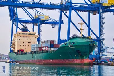
CACHALOT
Container Ship

Current Trip
| Time Travelled | 7 days |
|---|---|
| Remaining Time | --- |
| Distance Travelled | 1403.64 nm |
| Remaining Distance | --- |
| AVG Speed | 11.8 Knots |
| MAX Speed | 14 Knots |
| AVG Wind | 8.2 knots |
| MAX Wind | 28.8 knots |
| MIN Temp | 16.5°C / 61.7°F |
| MAX Temp | 25.6°C / 78.08°F |
| Draught | 9 m |
| Position Received | 1 d ago |
Current Position
| Longitude | 32.41427° |
|---|---|
| Latitude | 31.39473° |
| Status | Under way using engine |
| Speed | 10.8 Knots |
| Course | 209.4° |
| Area | Mediterranean Sea - Eastern Basin |
| Station | T-AIS |
| Position Received | 1 d ago |
Information
The current position of CACHALOT is in Mediterranean Sea - Eastern Basin with coordinates 31.39473° / 32.41427° as reported on 2025-05-26 12:34 by AIS to our vessel tracker app. The vessel's current speed is 10.8 Knots
The vessel CACHALOT (IMO: 9212022, MMSI: 538005039) is a Container Ship that was built in 2000 ( 25 years old ). It's sailing under the flag of [MH] Marshall Is.
In this page you can find informations about the vessels current position, last detected port calls, and current voyage information. If the vessels is not in coverage by AIS you will find the latest position.
The current position of CACHALOT is detected by our AIS receivers and we are not responsible for the reliability of the data. The last position was recorded while the vessel was in Coverage by the Ais receivers of our vessel tracking app.
The current draught of CACHALOT as reported by AIS is 9 meters
Weather
| Temperature | 20.8°C / 69.44°F |
|---|---|
| Wind Speed | 18 knots |
| Direction | 297° WNW |
| Pressure | 1012.8 hPa |
| Humidity | 71.6 % |
| Cloud Coverage | --- |


Featured Company
Last Port Calls
| Port | Arrival | Departure | Time In Port |
|---|---|---|---|
| 2025-05-26 13:46 | 2025-05-27 07:30 | 17 h | |
| 2025-05-19 05:07 | 2025-05-20 18:07 | 1 d | |
| 2025-05-15 15:39 | 2025-05-16 18:41 | 1 d | |
| 2025-05-08 23:41 | 2025-05-09 17:58 | 18 h | |
| 2025-05-01 15:06 | 2025-05-02 14:12 | 23 h | |
| 2025-04-29 19:55 | 2025-04-30 22:05 | 1 d | |
| 2025-04-24 12:58 | 2025-04-26 05:52 | 1 d | |
| 2025-04-18 09:40 | 2025-04-19 18:35 | 1 d | |
| 2025-04-17 04:24 | 2025-04-17 17:46 | 13 h | |
| 2025-04-13 00:22 | 2025-04-13 21:04 | 20 h |
Last Trips
| Origin | Departure | Destination | Arrival | Distance | |
|---|---|---|---|---|---|
| 2025-05-20 20:07 | 2025-05-26 15:46 | 1345.89 nm | |||
| 2025-05-16 20:41 | 2025-05-19 07:07 | 151.47 nm | |||
| 2025-05-02 16:12 | 2025-05-15 17:39 | 2459.30 nm | |||
| 2025-05-02 16:12 | 2025-05-09 01:41 | 1230.78 nm | |||
| 2025-05-01 00:05 | 2025-05-01 17:06 | 143.18 nm | |||
| 2025-04-19 20:35 | 2025-04-29 21:55 | 2704.90 nm | |||
| 2025-04-19 20:35 | 2025-04-24 14:58 | 1371.73 nm | |||
| 2025-04-17 19:46 | 2025-04-18 11:40 | 144.03 nm | |||
| 2025-04-12 21:31 | 2025-04-17 06:24 | 1291.45 nm | |||
| 2025-04-12 21:31 | 2025-04-13 02:22 | 59.76 nm |
Events
| Time | Event | Details | Position / Dest | Info |
|---|---|---|---|---|
| 2025-05-27 07:30 | PORT DEPARTURE |
|
31.24252 / 32.36167
PORT SAID EAST EGYPT
|
Speed: 6.9 kn Course: 13° |
| 2025-05-27 07:15 | START Moving |
31.21167 / 32.35341
[EG] SUEZ CANAL
|
Speed: 3.1 kn Course: 10° |
|
| 2025-05-26 13:58 | STOP Moving |
31.21177 / 32.35559
[EG] SUEZ CANAL
|
Speed: 0.1 kn Course: 192° |
|
| 2025-05-26 13:46 | PORT ARRIVAL |
|
31.21430 / 32.35460
[EG] SUEZ CANAL
|
Speed: 7.6 kn Course: 192° |
| 2025-05-26 12:35 | Status Changed | Default Under way using engine |
31.39384 / 32.41371
PORT SAID EAST EGYPT
|
Speed: 10.8 kn Course: 209.4° |
| 2025-05-26 12:34 | Status Changed | Under way using engine Default |
31.39473 / 32.41427
PORT SAID EAST EGYPT
|
Speed: 10.8 kn Course: 213° |
| 2025-05-26 12:34 | OUT of Coverage |
31.39473 / 32.41427
Mediterranean Sea - Eastern Basin
|
Speed: 10.8 kn Course: 209.4° |
|
| 2025-05-26 12:26 | Status Changed | Default Under way using engine |
31.41416 / 32.42921
PORT SAID EAST EGYPT
|
Speed: 7.4 kn Course: 213.4° |
| 2025-05-26 12:20 | Status Changed | Under way using engine Default |
31.42754 / 32.44004
PORT SAID EAST EGYPT
|
Speed: 6.6 kn Course: 214° |
| 2025-05-26 12:19 | Status Changed | Default Under way using engine |
31.42923 / 32.44132
PORT SAID EAST EGYPT
|
Speed: 3.9 kn Course: 221° |