

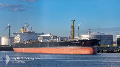
CAPTAIN SPIRO
Tanker

Current Trip
KRTSN
| Time Travelled | 5 days |
|---|---|
| Remaining Time | --- |
| Distance Travelled | 1512.07 nm |
| Remaining Distance | --- |
| AVG Speed | 11.7 Knots |
| MAX Speed | 13.5 Knots |
| AVG Wind | 12.9 knots |
| MAX Wind | 20.3 knots |
| MIN Temp | 22.5°C / 72.5°F |
| MAX Temp | 29.7°C / 85.46°F |
| Draught | 12.9 m |
| Position Received | 18 d ago |
Current Position
| Longitude | 104.12681° |
|---|---|
| Latitude | 1.25402° |
| Status | Under way using engine |
| Speed | 12.1 Knots |
| Course | 79.7° |
| Area | Singapore Strait |
| Station | T-AIS |
| Position Received | 18 d ago |
Information
The current position of CAPTAIN SPIRO is in Singapore Strait with coordinates 1.25402° / 104.12681° as reported on 2025-09-04 06:24 by AIS to our vessel tracker app. The vessel's current speed is 12.1 Knots
The vessel CAPTAIN SPIRO (IMO: 9692856, MMSI: 229715000) is a Tanker It's sailing under the flag of [MT] Malta.
In this page you can find informations about the vessels current position, last detected port calls, and current voyage information. If the vessels is not in coverage by AIS you will find the latest position.
The current position of CAPTAIN SPIRO is detected by our AIS receivers and we are not responsible for the reliability of the data. The last position was recorded while the vessel was in Coverage by the Ais receivers of our vessel tracking app.
The current draught of CAPTAIN SPIRO as reported by AIS is 12.9 meters
Weather
| Temperature | 28.2°C / 82.76°F |
|---|---|
| Wind Speed | 17 knots |
| Direction | 251° WSW |
| Pressure | 1003.7 hPa |
| Humidity | 77.5 % |
| Cloud Coverage | 100 % |


Featured Company
Most Visited Ports (Last year)
| Port | Arrivals | |
|---|---|---|
| 2 | ||
| 2 | ||
| 1 | ||
| 1 | ||
| 1 | ||
| 1 |
Events
| Time | Event | Details | Position / Dest | Info |
|---|---|---|---|---|
| 2025-09-17 10:15 | START Moving | 1.03 nm, East of DAESAN |
37.02792 / 126.40067
KRTSN
|
Speed: 4.8 kn Course: 295° |
| 2025-09-17 10:15 | PORT DEPARTURE |
|
37.02792 / 126.40067
KRTSN
|
Speed: 2.9 kn Course: 295° |
| 2025-09-16 01:59 | STOP Moving |
37.02299 / 126.40717
[KR] DAESAN
|
Speed: Course: 107° |
|
| 2025-09-16 01:59 | PORT ARRIVAL |
|
37.02299 / 126.40717
[KR] DAESAN
|
Speed: 1 kn Course: 128° |
| 2025-09-16 00:56 | START Moving | 3.38 nm, West of DAESAN |
37.01255 / 126.31114
KRTSN
|
Speed: 8.4 kn Course: 75° |
| 2025-09-14 23:57 | STOP Moving | 4.18 nm, West of DAESAN |
37.01048 / 126.29455
KRTSN
|
Speed: Course: 269° |
| 2025-09-14 23:24 | PORT DEPARTURE |
|
37.01280 / 126.31722
KRTSN
|
Speed: Course: 244° |
| 2025-09-13 05:13 | STOP Moving |
37.00540 / 126.33343
[KR] DAESAN
|
Speed: Course: 245° |
|
| 2025-09-13 05:11 | PORT ARRIVAL |
|
37.00551 / 126.33320
[KR] DAESAN
|
Speed: 3 kn Course: 152° |
| 2025-09-13 02:07 | START Moving | 9.62 nm, North West of TAEAN-GUN |
37.05727 / 126.14608
KRTSN
|
Speed: 5.9 kn Course: 268° |