
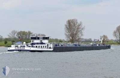
CHRIS
Tanker
Current Trip
| Time Travelled | 6 h, 31 mins |
|---|---|
| Remaining Time | 8 h, 53 mins |
| Distance Travelled | 35.06 nm |
| Remaining Distance | 67.38 nm |
| AVG Speed | 6.8 Knots |
| MAX Speed | 7.6 Knots |
| AVG Wind | 13.7 knots |
| MAX Wind | 14 knots |
| MIN Temp | 1.4°C / 34.52°F |
| MAX Temp | 2.9°C / 37.22°F |
| Draught | 2.3 m |
| Position Received | 44 m ago |
Current Position
| Longitude | 5.68936° |
|---|---|
| Latitude | 52.97707° |
| Status | Under way using engine |
| Speed | 6.9 Knots |
| Course | 165.4° |
| Area | North Sea |
| Station | T-AIS |
| Position Received | 44 m ago |
Info
Information
The current position of CHRIS is in North Sea with coordinates 52.97707° / 5.68936° as reported on 2025-02-10 10:56 by AIS to our vessel tracker app. The vessel's current speed is 6.9 Knots and is heading at the port of NIEUWEGEIN. The estimated time of arrival as calculated by MyShipTracking vessel tracking app is 2025-02-10 20:33 LT
The vessel CHRIS (MMSI: 205244190) is a Tanker It's sailing under the flag of [BE] Belgium.
In this page you can find informations about the vessels current position, last detected port calls, and current voyage information. If the vessels is not in coverage by AIS you will find the latest position.
The current position of CHRIS is detected by our AIS receivers and we are not responsible for the reliability of the data. The last position was recorded while the vessel was in Coverage by the Ais receivers of our vessel tracking app.
The current draught of CHRIS as reported by AIS is 2.3 meters
Weather
| Temperature | 2.4°C / 36.32°F |
|---|---|
| Wind Speed | 13 knots |
| Direction | 72° ENE |
| Pressure | 1028.7 hPa |
| Humidity | 75.2 % |
| Cloud Coverage | 78 % |
Featured Company
Last Port Calls
| Port | Arrival | Departure | Time In Port |
|---|---|---|---|
| 2025-02-09 18:24 | 2025-02-10 05:09 | 10 h | |
| 2025-02-09 16:03 | 2025-02-09 16:30 | 27 m | |
| 2025-02-09 07:37 | 2025-02-09 14:42 | 7 h | |
| 2025-02-08 17:59 | 2025-02-09 05:56 | 11 h | |
| 2025-02-08 15:36 | 2025-02-08 16:04 | 27 m | |
| 2025-02-07 14:51 | 2025-02-07 19:05 | 4 h | |
| 2025-02-06 09:03 | 2025-02-07 13:18 | 1 d | |
| 2025-02-05 07:09 | 2025-02-06 07:40 | 1 d | |
| 2025-02-04 06:54 | 2025-02-05 06:39 | 23 h | |
| 2025-02-02 22:10 | 2025-02-04 06:32 | 1 d |
Most Visited Ports (Last year)
| Port | Arrivals | |
|---|---|---|
| 104 | ||
| 90 | ||
| 49 | ||
| 38 | ||
| 31 | ||
| 18 |
Last Trips
| Origin | Departure | Destination | Arrival | Distance | |
|---|---|---|---|---|---|
| 2025-02-09 17:30 | 2025-02-09 19:24 | 12.16 nm | |||
| 2025-02-09 15:42 | 2025-02-09 17:03 | 13.46 nm | |||
| 2025-02-09 06:56 | 2025-02-09 08:37 | 13.43 nm | |||
| 2025-02-08 17:04 | 2025-02-08 18:59 | 11.78 nm | |||
| 2025-02-07 20:05 | 2025-02-08 16:36 | 90.67 nm | |||
| 2025-02-07 14:18 | 2025-02-07 15:51 | 9.13 nm | |||
| 2025-02-06 08:40 | 2025-02-06 10:03 | 6.13 nm | |||
| 2025-02-05 07:39 | 2025-02-05 08:09 | 3.27 nm | |||
| 2025-02-04 07:32 | 2025-02-04 07:54 | 0.57 nm | |||
| 2025-02-02 19:46 | 2025-02-02 23:10 | 26.34 nm |
Events
| Time | Event | Details | Position / Dest | Info |
|---|---|---|---|---|
| 2025-02-10 10:11 | IN Coverage |
53.04355 / 5.76577
North Sea
|
Speed: 4.3 kn Course: 238.7° |
|
| 2025-02-10 08:03 | OUT of Coverage |
53.19562 / 6.03713
North Sea
|
Speed: 7.5 kn Course: 248° |
|
| 2025-02-10 08:03 | Status Changed | Under way using engine Default |
53.19601 / 6.03874
AMSTERDAM HORNHAVEN
|
Speed: 6.3 kn Course: 259° |
| 2025-02-10 07:54 | Status Changed | Default Under way using engine |
53.20021 / 6.06469
AMSTERDAM HORNHAVEN
|
Speed: 5.6 kn Course: 231.4° |
| 2025-02-10 06:27 | START Moving | 3 nm, West of BRILTIL |
53.24856 / 6.30819
AMSTERDAM HORNHAVEN
|
Speed: 5.1 kn Course: 257.5° |
| 2025-02-10 06:18 | STOP Moving | 2.85 nm, West of BRILTIL |
53.24896 / 6.31208
AMSTERDAM HORNHAVEN
|
Speed: 0.1 kn Course: 511° |
| 2025-02-10 05:14 | IN Coverage |
53.25829 / 6.50405
North Sea
AMSTERDAM HORNHAVEN
|
Speed: 5.5 kn Course: 292.4° |
|
| 2025-02-10 05:09 | PORT DEPARTURE |
|
53.25829 / 6.50405
AMSTERDAM HORNHAVEN
|
Speed: Course: 511° |
| 2025-02-09 20:13 | OUT of Coverage |
53.25473 / 6.51568
North Sea
[NL] GRONINGEN
|
Speed: Course: 511° |
|
| 2025-02-09 19:54 | STOP Moving |
53.25480 / 6.51579
[NL] GRONINGEN
|
Speed: 0.3 kn Course: 511° |