

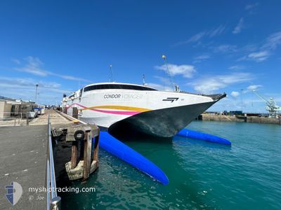
CONDOR VOYAGER
High speed craft

Current Trip
| Trip Time | 1 h, 43 mins |
|---|---|
| Trip Distance | 53.76 nm |
| AVG Speed | 34.3 Knots |
| MAX Speed | 36.2 Knots |
| Draught | 2.7 m |
| AVG Wind | 10.1 knots |
| MAX Wind | 12 knots |
| MIN Temp | 13.9°C / 57.02°F |
| MAX Temp | 14.2°C / 57.56°F |
| Position Received | 1 m ago |
Current Position
| Longitude | -2.02853° |
|---|---|
| Latitude | 48.64106° |
| Status | Under way using engine |
| Speed | |
| Course | 262° |
| Area | English Channel |
| Station | T-AIS |
| Position Received | 1 m ago |
Information
The current position of CONDOR VOYAGER is in English Channel with coordinates 48.64106° / -2.02853° as reported on 2025-06-09 00:40 by AIS to our vessel tracker app. The vessel's current speed is 0 Knots and is currently inside the port of SAINT MALO.
The vessel CONDOR VOYAGER (IMO: 9221358, MMSI: 311001050) is a High speed craft that was built in 2000 ( 25 years old ). It's sailing under the flag of [BS] Bahamas.
In this page you can find informations about the vessels current position, last detected port calls, and current voyage information. If the vessels is not in coverage by AIS you will find the latest position.
The current position of CONDOR VOYAGER is detected by our AIS receivers and we are not responsible for the reliability of the data. The last position was recorded while the vessel was in Coverage by the Ais receivers of our vessel tracking app.
The current draught of CONDOR VOYAGER as reported by AIS is 2.7 meters
Weather
| Temperature | 13.9°C / 57.02°F |
|---|---|
| Wind Speed | 7 knots |
| Direction | 227° SW |
| Pressure | 1024.5 hPa |
| Humidity | 77.3 % |
| Cloud Coverage | 6 % |


Featured Company
Last Port Calls
| Port | Arrival | Departure | Time In Port |
|---|---|---|---|
| 2025-06-08 21:30 | |||
| 2025-06-08 17:57 | 2025-06-08 18:47 | 49 m | |
| 2025-06-08 13:23 | 2025-06-08 14:51 | 1 h | |
| 2025-06-08 08:45 | 2025-06-08 10:06 | 1 h | |
| 2025-06-07 11:05 | 2025-06-08 07:56 | 20 h | |
| 2025-06-07 07:29 | 2025-06-07 08:06 | 36 m | |
| 2025-06-06 21:42 | 2025-06-07 06:38 | 8 h | |
| 2025-06-06 18:10 | 2025-06-06 19:00 | 49 m | |
| 2025-06-06 13:34 | 2025-06-06 15:04 | 1 h | |
| 2025-06-06 08:39 | 2025-06-06 10:21 | 1 h |
Most Visited Ports (Last year)
| Port | Arrivals | |
|---|---|---|
| 434 | ||
| 329 | ||
| 238 | ||
| 46 |
Last Trips
| Origin | Departure | Destination | Arrival | Distance | |
|---|---|---|---|---|---|
| 2025-06-08 18:47 | 2025-06-08 21:30 | 53.76 nm | |||
| 2025-06-08 14:51 | 2025-06-08 17:57 | 83.23 nm | |||
| 2025-06-08 10:06 | 2025-06-08 13:23 | 82.67 nm | |||
| 2025-06-08 07:56 | 2025-06-08 08:45 | 54.32 nm | |||
| 2025-06-07 08:06 | 2025-06-07 11:05 | 53.82 nm | |||
| 2025-06-07 06:38 | 2025-06-07 07:29 | 54.55 nm | |||
| 2025-06-06 19:00 | 2025-06-06 21:42 | 53.70 nm | |||
| 2025-06-06 15:04 | 2025-06-06 18:10 | 82.21 nm | |||
| 2025-06-06 10:21 | 2025-06-06 13:34 | 81.73 nm | |||
| 2025-06-06 07:50 | 2025-06-06 08:39 | 54.38 nm |
Events
| Time | Event | Details | Position / Dest | Info |
|---|---|---|---|---|
| 2025-06-08 19:35 | STOP Moving |
48.64105 / -2.02869
[FR] SAINT MALO
|
Speed: 0.3 kn Course: 262° |
|
| 2025-06-08 19:30 | PORT ARRIVAL |
|
48.64130 / -2.03203
[FR] SAINT MALO
|
Speed: 7.5 kn Course: 134.5° |
| 2025-06-08 19:14 | Change Sea Area | French part of the English Channel Jersey part of the English Channel |
48.72171 / -2.13013
English Channel
FRSML
|
Speed: 35.7 kn Course: 148.9° |
| 2025-06-08 19:14 | Status Changed | Under way using engine Default |
48.72171 / -2.13013
FRSML
|
Speed: 35.5 kn Course: 151° |
| 2025-06-08 19:05 | Status Changed | Default Under way using engine |
48.79858 / -2.20277
FRSML
|
Speed: 33.7 kn Course: 151.8° |
| 2025-06-08 18:53 | Status Changed | Under way using engine Default |
48.89597 / -2.29386
FRSML
|
Speed: 33.8 kn Course: 171° |
| 2025-06-08 18:21 | Status Changed | Default Under way using engine |
49.17976 / -2.41426
FRSML
|
Speed: 34.1 kn Course: 167° |
| 2025-06-08 18:11 | Change Sea Area | Jersey part of the English Channel Guernsey part of the English Channel |
49.26748 / -2.44279
English Channel
FRSML
|
Speed: 34.2 kn Course: 165.4° |
| 2025-06-08 17:47 | PORT DEPARTURE |
|
49.45589 / -2.52296
FRSML
|
Speed: 8.3 kn Course: 88° |
| 2025-06-08 17:47 | START Moving |
49.45578 / -2.52499
[GG] GUERNSEY
|
Speed: 7.7 kn Course: 83° |