
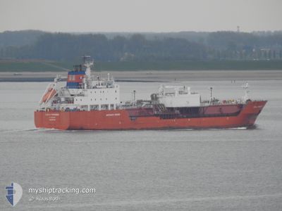
CORAL PARENSIS
Lpg Tanker
Current Trip
| Trip Time | 3 days |
|---|---|
| Trip Distance | 840.53 nm |
| AVG Speed | 12.8 Knots |
| MAX Speed | 16.3 Knots |
| Draught | 6.7 m |
| AVG Wind | 8.1 knots |
| MAX Wind | 17.7 knots |
| MIN Temp | 13.4°C / 56.12°F |
| MAX Temp | 16.7°C / 62.06°F |
| Position Received | 2 d ago |
Current Position
| Longitude | 14.74886° |
|---|---|
| Latitude | 35.90360° |
| Status | Under way using engine |
| Speed | 2.9 Knots |
| Course | 120° |
| Area | Mediterranean Sea - Eastern Basin |
| Station | T-AIS |
| Position Received | 2 d ago |
Info
Information
The current position of CORAL PARENSIS is in Mediterranean Sea - Eastern Basin with coordinates 35.90360° / 14.74886° as reported on 2025-02-05 05:46 by AIS to our vessel tracker app. The vessel's current speed is 2.9 Knots and is currently inside the port of RAS LANUF.
The vessel CORAL PARENSIS (IMO: 9208148, MMSI: 246605000) is a Lpg Tanker that was built in 2000 ( 25 years old ). It's sailing under the flag of [NL] Netherlands.
In this page you can find informations about the vessels current position, last detected port calls, and current voyage information. If the vessels is not in coverage by AIS you will find the latest position.
The current position of CORAL PARENSIS is detected by our AIS receivers and we are not responsible for the reliability of the data. The last position was recorded while the vessel was in Coverage by the Ais receivers of our vessel tracking app.
The current draught of CORAL PARENSIS as reported by AIS is 6.7 meters
Weather
| Temperature | 15.5°C / 59.9°F |
|---|---|
| Wind Speed | 14 knots |
| Direction | 110° ESE |
| Pressure | 1026.7 hPa |
| Humidity | 49.8 % |
| Cloud Coverage | --- |
Featured Company
Last Port Calls
| Port | Arrival | Departure | Time In Port |
|---|---|---|---|
| 2025-02-06 19:48 | |||
| 2025-02-01 00:36 | 2025-02-03 11:55 | 2 d | |
| 2025-01-26 15:05 | 2025-01-28 11:28 | 1 d | |
| 2025-01-09 12:04 | 2025-01-10 09:13 | 21 h | |
| 2025-01-05 08:47 | 2025-01-07 10:06 | 2 d | |
| 2025-01-02 11:03 | 2025-01-03 08:25 | 21 h | |
| 2024-12-30 06:55 | 2024-12-31 13:37 | 1 d | |
| 2024-12-23 22:46 | 2024-12-25 16:20 | 1 d | |
| 2024-12-11 08:24 | 2024-12-13 08:17 | 1 d | |
| 2024-12-08 21:05 | 2024-12-09 21:18 | 1 d |
Last Trips
| Origin | Departure | Destination | Arrival | Distance | |
|---|---|---|---|---|---|
| 2025-02-03 11:55 | 2025-02-06 19:48 | 840.53 nm | |||
| 2025-01-28 11:28 | 2025-02-01 00:36 | 1083.52 nm | |||
| 2025-01-10 09:13 | 2025-01-26 15:05 | 4092.17 nm | |||
| 2025-01-07 10:06 | 2025-01-09 12:04 | 587.79 nm | |||
| 2025-01-03 08:25 | 2025-01-05 08:47 | 584.57 nm | |||
| 2024-12-31 13:37 | 2025-01-02 11:03 | 586.62 nm | |||
| 2024-12-25 16:20 | 2024-12-30 06:55 | 591.73 nm | |||
| 2024-12-13 08:17 | 2024-12-23 22:46 | 550.86 nm | |||
| 2024-12-09 21:18 | 2024-12-11 08:24 | 412.75 nm | |||
| 2024-11-29 09:45 | 2024-12-08 21:05 | 455.64 nm |
Events
| Time | Event | Details | Position / Dest | Info |
|---|---|---|---|---|
| 2025-02-06 18:18 | STOP Moving |
30.49418 / 18.58464
[LY] RAS LANUF
|
Speed: 0.1 kn Course: 313° |
|
| 2025-02-06 17:48 | PORT ARRIVAL |
|
30.50760 / 18.58869
[LY] RAS LANUF
|
Speed: 9.8 kn Course: 246° |
| 2025-02-06 17:18 | START Moving | 3.48 nm, East of RAS LANUF |
30.52004 / 18.65006
MT MLA
|
Speed: 3.4 kn Course: 255° |
| 2025-02-06 13:45 | STOP Moving | 2.75 nm, North East of RAS LANUF |
30.53473 / 18.62348
MT MLA
|
Speed: 0.2 kn Course: 71° |
| 2025-02-05 05:53 | Status Changed | Default Under way using engine |
35.89432 / 14.76596
MT MLA
|
Speed: 2.9 kn Course: 120° |
| 2025-02-05 05:53 | START Moving | 11.49 nm, East of MARSAXLOKK |
35.89432 / 14.76596
MT MLA
|
Speed: 11.6 kn Course: 123° |
| 2025-02-05 05:46 | OUT of Coverage |
35.90360 / 14.74886
Mediterranean Sea - Eastern Basin
|
Speed: 2.9 kn Course: 130.5° |
|
| 2025-02-05 05:46 | Status Changed | Under way using engine Default |
35.90369 / 14.74872
MT MLA
|
Speed: 1.4 kn Course: 119° |
| 2025-02-05 05:41 | IN Coverage |
35.90360 / 14.74886
Mediterranean Sea - Eastern Basin
|
Speed: 2.9 kn Course: 130.5° |
|
| 2025-02-04 17:19 | OUT of Coverage |
35.90532 / 14.74536
Mediterranean Sea - Eastern Basin
MT MLA
|
Speed: 2.3 kn Course: 134.6° |