

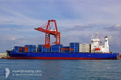
CORELLI
Container Ship

Current Trip
Current Position
| Longitude | 28.68381° |
|---|---|
| Latitude | 40.96508° |
| Status | Moored |
| Speed | |
| Course | 356° |
| Area | Sea of Marmara |
| Station | T-AIS |
| Position Received | 1 m ago |
Information
The current position of CORELLI is in Sea of Marmara with coordinates 40.96508° / 28.68381° as reported on 2025-05-24 17:41 by AIS to our vessel tracker app. The vessel's current speed is 0 Knots and is currently inside the port of AMBARLI.
The vessel CORELLI (IMO: 9126766, MMSI: 271050950) is a Container Ship that was built in 1997 ( 28 years old ). It's sailing under the flag of [TR] Turkey.
In this page you can find informations about the vessels current position, last detected port calls, and current voyage information. If the vessels is not in coverage by AIS you will find the latest position.
The current position of CORELLI is detected by our AIS receivers and we are not responsible for the reliability of the data. The last position was recorded while the vessel was in Coverage by the Ais receivers of our vessel tracking app.
The current draught of CORELLI as reported by AIS is 7.4 meters
Weather
| Temperature | 21.7°C / 71.06°F |
|---|---|
| Wind Speed | 13 knots |
| Direction | 43° NE |
| Pressure | 1008.8 hPa |
| Humidity | 60.7 % |
| Cloud Coverage | 61 % |


Featured Company
Last Port Calls
| Port | Arrival | Departure | Time In Port |
|---|---|---|---|
| 2025-05-24 13:24 | |||
| 2025-05-23 09:36 | 2025-05-24 13:13 | 1 d | |
| 2025-05-20 00:17 | 2025-05-21 23:05 | 1 d | |
| 2025-05-15 06:49 | 2025-05-17 15:35 | 2 d | |
| 2025-05-12 14:06 | 2025-05-14 06:49 | 1 d | |
| 2025-05-08 15:24 | 2025-05-09 05:04 | 13 h | |
| 2025-05-06 20:50 | 2025-05-07 15:29 | 18 h | |
| 2025-05-06 04:20 | 2025-05-06 16:04 | 11 h | |
| 2025-05-05 10:11 | 2025-05-06 04:06 | 17 h | |
| 2025-04-30 13:32 | 2025-05-03 15:14 | 3 d |
Most Visited Ports (Last year)
| Port | Arrivals | |
|---|---|---|
| 31 | ||
| 24 | ||
| 17 | ||
| 13 | ||
| 10 | ||
| 10 |
Last Trips
| Origin | Departure | Destination | Arrival | Distance | |
|---|---|---|---|---|---|
| 2025-05-24 13:13 | 2025-05-24 13:24 | 0.32 nm | |||
| 2025-05-21 23:05 | 2025-05-23 09:36 | 362.84 nm | |||
| 2025-05-17 15:35 | 2025-05-20 00:17 | 288.33 nm | |||
| 2025-05-14 06:49 | 2025-05-15 06:49 | 280.16 nm | |||
| 2025-05-09 05:04 | 2025-05-12 14:06 | 209.00 nm | |||
| 2025-05-07 15:29 | 2025-05-08 15:24 | 311.02 nm | |||
| 2025-05-06 16:04 | 2025-05-06 20:50 | 53.53 nm | |||
| 2025-05-06 04:06 | 2025-05-06 04:20 | 0.49 nm | |||
| 2025-05-03 15:14 | 2025-05-05 10:11 | 394.01 nm | |||
| 2025-04-22 07:08 | 2025-04-30 13:32 | 317.15 nm |
Events
| Time | Event | Details | Position / Dest | Info |
|---|---|---|---|---|
| 2025-05-24 17:37 | Status Changed | Moored Default |
40.96510 / 28.68381
[TR] AMBARLI
|
Speed: Course: 357° |
| 2025-05-24 17:32 | Status Changed | Default Moored |
40.96508 / 28.68383
[TR] AMBARLI
|
Speed: Course: 357° |
| 2025-05-24 10:32 | STOP Moving |
40.96509 / 28.68380
[TR] AMBARLI
|
Speed: 0.2 kn Course: 356° |
|
| 2025-05-24 10:24 | PORT ARRIVAL |
|
40.96232 / 28.68379
[TR] AMBARLI
|
Speed: 2.9 kn Course: 355° |
| 2025-05-24 10:13 | PORT DEPARTURE |
|
40.95814 / 28.68282
TRAMB
|
Speed: 2.5 kn Course: 253° |
| 2025-05-24 10:08 | START Moving |
40.95728 / 28.67684
[TR] AMBARLI
|
Speed: 3.2 kn Course: 280° |
|
| 2025-05-24 09:42 | ETA Changed | 2025/05/24 10:45 2025/05/23 05:00 |
40.95786 / 28.67307
[TR] AMBARLI
|
Speed: Course: 305° |
| 2025-05-24 01:35 | Draught Changed | 7.4 7.1 |
40.95785 / 28.67312
[TR] AMBARLI
|
Speed: Course: 305° |
| 2025-05-23 06:53 | Status Changed | Moored Under way using engine |
40.95783 / 28.67309
[TR] AMBARLI
|
Speed: Course: 304° |
| 2025-05-23 06:44 | STOP Moving |
40.95801 / 28.67330
[TR] AMBARLI
|
Speed: 0.2 kn Course: 306° |