
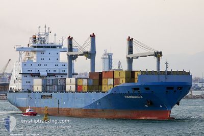
DONG FANG QIANG
Container Ship
Current Trip
| Time Travelled | 1 day |
|---|---|
| Remaining Time | --- |
| Distance Travelled | 488.37 nm |
| Remaining Distance | 670.72 nm |
| AVG Speed | 14.6 Knots |
| MAX Speed | 16.5 Knots |
| AVG Wind | 8.9 knots |
| MAX Wind | 22 knots |
| MIN Temp | 4.2°C / 39.56°F |
| MAX Temp | 10.2°C / 50.36°F |
| Draught | 10.3 m |
| Position Received | 6 d ago |
Current Position
| Longitude | 121.11069° |
|---|---|
| Latitude | 25.16418° |
| Status | Under way using engine |
| Speed | 16.7 Knots |
| Course | 52.5° |
| Area | South China Sea |
| Station | T-AIS |
| Position Received | 6 d ago |
Info
Information
The current position of DONG FANG QIANG is in South China Sea with coordinates 25.16418° / 121.11069° as reported on 2025-12-09 21:21 by AIS to our vessel tracker app. The vessel's current speed is 16.7 Knots and is heading at the port of KEELUNG. The estimated time of arrival as calculated by MyShipTracking vessel tracking app is 2025-12-10 17:00 LT
The vessel DONG FANG QIANG (IMO: 9122538, MMSI: 413695760) is a Container Ship that was built in 1996 ( 29 years old ). It's sailing under the flag of [CN] China.
In this page you can find informations about the vessels current position, last detected port calls, and current voyage information. If the vessels is not in coverage by AIS you will find the latest position.
The current position of DONG FANG QIANG is detected by our AIS receivers and we are not responsible for the reliability of the data. The last position was recorded while the vessel was in Coverage by the Ais receivers of our vessel tracking app.
The current draught of DONG FANG QIANG as reported by AIS is 10.3 meters
Weather
| Temperature | 4.6°C / 40.28°F |
|---|---|
| Wind Speed | 21 knots |
| Direction | 360° N |
| Pressure | 1027.3 hPa |
| Humidity | 74.6 % |
| Cloud Coverage | 5 % |
Featured Company
Last Port Calls
| Port | Arrival | Departure | Time In Port |
|---|---|---|---|
| 2025-12-14 19:29 | 2025-12-15 15:37 | 20 h | |
| 2025-12-10 08:10 | 2025-12-11 20:01 | 1 d | |
| 2025-12-09 00:41 | 2025-12-09 16:09 | 15 h | |
| 2025-12-08 00:28 | 2025-12-08 15:28 | 14 h | |
| 2025-12-04 22:40 | 2025-12-05 13:29 | 14 h | |
| 2025-12-03 22:45 | 2025-12-04 16:33 | 17 h | |
| 2025-12-01 06:21 | 2025-12-02 04:33 | 22 h | |
| 2025-11-26 23:59 | 2025-11-28 10:48 | 1 d | |
| 2025-11-25 09:34 | 2025-11-26 00:20 | 14 h | |
| 2025-11-24 09:36 | 2025-11-25 00:07 | 14 h |
Last Trips
| Origin | Departure | Destination | Arrival | Distance | |
|---|---|---|---|---|---|
| 2025-12-11 20:01 | 2025-12-14 19:29 | 1011.66 nm | |||
| 2025-12-09 16:09 | 2025-12-10 08:10 | 232.80 nm | |||
| 2025-12-08 15:28 | 2025-12-09 00:41 | 133.89 nm | |||
| 2025-12-05 13:29 | 2025-12-08 00:28 | 811.20 nm | |||
| 2025-12-04 16:33 | 2025-12-04 22:40 | 74.58 nm | |||
| 2025-12-02 04:33 | 2025-12-03 22:45 | 489.06 nm | |||
| 2025-11-28 10:48 | 2025-12-01 06:21 | 1005.26 nm | |||
| 2025-11-26 00:20 | 2025-11-26 23:59 | 244.97 nm | |||
| 2025-11-25 00:07 | 2025-11-25 09:34 | 133.67 nm | |||
| 2025-11-22 01:12 | 2025-11-24 09:36 | 787.27 nm |
Events
| Time | Event | Details | Position / Dest | Info |
|---|---|---|---|---|
| 2025-12-16 17:28 | STOP Moving | 6.01 nm, East of RIZHAO |
35.35302 / 119.65107
TW KEL
|
Speed: 0.2 kn Course: 2° |
| 2025-12-15 07:37 | PORT DEPARTURE |
|
38.95340 / 117.89503
TW KEL
|
Speed: 12.5 kn Course: 101° |
| 2025-12-15 07:13 | START Moving |
38.97019 / 117.79195
[CN] TIANJIN
|
Speed: 8.8 kn Course: 103° |
|
| 2025-12-14 11:29 | STOP Moving |
38.97539 / 117.77953
[CN] TIANJIN
|
Speed: 0.2 kn Course: 296° |
|
| 2025-12-14 11:29 | PORT ARRIVAL |
|
38.97539 / 117.77953
[CN] TIANJIN
|
Speed: 4 kn Course: 284° |
| 2025-12-11 12:01 | PORT DEPARTURE |
|
25.17467 / 121.75232
TW KEL
|
Speed: 10.1 kn Course: 338° |
| 2025-12-11 11:45 | START Moving |
25.15255 / 121.75324
[TW] KEELUNG
|
Speed: 3.8 kn Course: 279° |
|
| 2025-12-10 00:56 | STOP Moving |
25.15229 / 121.75079
[TW] KEELUNG
|
Speed: Course: 241° |
|
| 2025-12-10 00:10 | PORT ARRIVAL |
|
25.15229 / 121.75079
[TW] KEELUNG
|
Speed: 9 kn Course: 154° |
| 2025-12-09 21:21 | OUT of Coverage |
25.16418 / 121.11069
South China Sea
TW KEL
|
Speed: 16.7 kn Course: 52.5° |