

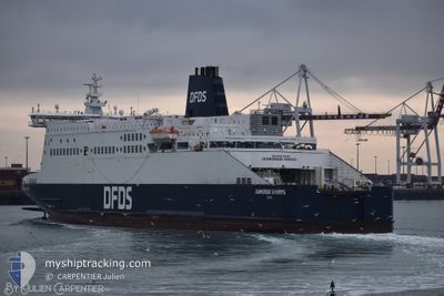
DUNKERQUE SEAWAYS
Ro-Ro/Passenger Ship

Current Trip
| Time Travelled | 1 h, 30 mins |
|---|---|
| Remaining Time | 12 mins |
| Distance Travelled | 27.20 nm |
| Remaining Distance | 8.82 nm |
| AVG Speed | 19.5 Knots |
| MAX Speed | 20.2 Knots |
| AVG Wind | 19.6 knots |
| MAX Wind | 23 knots |
| MIN Temp | 13.8°C / 56.84°F |
| MAX Temp | 17.5°C / 63.5°F |
| Draught | 6.5 m |
| Position Received | Now |
Current Position
| Longitude | 1.46486° |
|---|---|
| Latitude | 51.13249° |
| Status | Under way using engine |
| Speed | 17.4 Knots |
| Course | 256.6° |
| Area | North Sea |
| Station | T-AIS |
| Position Received | Now |
Information
The current position of DUNKERQUE SEAWAYS is in North Sea with coordinates 51.13249° / 1.46486° as reported on 2025-06-10 09:37 by AIS to our vessel tracker app. The vessel's current speed is 17.4 Knots and is heading at the port of DOVER. The estimated time of arrival as calculated by MyShipTracking vessel tracking app is 2025-06-10 10:50 LT
The vessel DUNKERQUE SEAWAYS (IMO: 9293076, MMSI: 235028825) is a Ro-Ro/Passenger Ship that was built in 2005 ( 20 years old ). It's sailing under the flag of [GB] United Kingdom.
In this page you can find informations about the vessels current position, last detected port calls, and current voyage information. If the vessels is not in coverage by AIS you will find the latest position.
The current position of DUNKERQUE SEAWAYS is detected by our AIS receivers and we are not responsible for the reliability of the data. The last position was recorded while the vessel was in Coverage by the Ais receivers of our vessel tracking app.
The current draught of DUNKERQUE SEAWAYS as reported by AIS is 6.5 meters
Weather
| Temperature | 17°C / 62.6°F |
|---|---|
| Wind Speed | 17 knots |
| Direction | 256° WSW |
| Pressure | 1015.3 hPa |
| Humidity | 75.8 % |
| Cloud Coverage | 100 % |


Featured Company
Last Port Calls
| Port | Arrival | Departure | Time In Port |
|---|---|---|---|
| 2025-06-10 08:50 | 2025-06-10 10:08 | 1 h | |
| 2025-06-10 05:07 | 2025-06-10 06:11 | 1 h | |
| 2025-06-09 21:02 | 2025-06-10 04:14 | 7 h | |
| 2025-06-09 16:57 | 2025-06-09 18:01 | 1 h | |
| 2025-06-09 14:57 | 2025-06-09 16:16 | 1 h | |
| 2025-06-09 11:03 | 2025-06-09 12:14 | 1 h | |
| 2025-06-09 08:54 | 2025-06-09 10:14 | 1 h | |
| 2025-06-09 04:55 | 2025-06-09 06:03 | 1 h | |
| 2025-06-08 21:02 | 2025-06-09 03:59 | 6 h | |
| 2025-06-08 17:10 | 2025-06-08 18:06 | 56 m |
Last Trips
| Origin | Departure | Destination | Arrival | Distance | |
|---|---|---|---|---|---|
| 2025-06-10 06:11 | 2025-06-10 08:50 | 31.92 nm | |||
| 2025-06-10 04:14 | 2025-06-10 05:07 | 31.58 nm | |||
| 2025-06-09 18:01 | 2025-06-09 21:02 | 32.76 nm | |||
| 2025-06-09 16:16 | 2025-06-09 16:57 | 32.65 nm | |||
| 2025-06-09 12:14 | 2025-06-09 14:57 | 32.43 nm | |||
| 2025-06-09 10:14 | 2025-06-09 11:03 | 31.74 nm | |||
| 2025-06-09 06:03 | 2025-06-09 08:54 | 33.01 nm | |||
| 2025-06-09 03:59 | 2025-06-09 04:55 | 31.77 nm | |||
| 2025-06-08 18:06 | 2025-06-08 21:02 | 31.67 nm | |||
| 2025-06-08 16:24 | 2025-06-08 17:10 | 34.28 nm |
Events
| Time | Event | Details | Position / Dest | Info |
|---|---|---|---|---|
| 2025-06-10 09:07 | Change Sea Area | United Kingdom part of the North Sea French part of the North Sea |
51.09526 / 1.67901
North Sea
GBDVR<>FRDKK
|
Speed: 20.1 kn Course: 315.4° |
| 2025-06-10 08:14 | ETA Changed | 2025/06/10 11:15 2025/06/10 08:15 |
51.05124 / 2.10083
GBDVR<>FRDKK
|
Speed: 19.7 kn Course: 276.5° |
| 2025-06-10 08:08 | PORT DEPARTURE |
|
51.04742 / 2.14867
GBDVR<>FRDKK
|
Speed: 18.6 kn Course: 299° |
| 2025-06-10 07:54 | START Moving |
51.01944 / 2.18363
[FR] DUNKERQUE
|
Speed: 7.1 kn Course: 56° |
|
| 2025-06-10 07:19 | Status Changed | Under way using engine Default |
51.02108 / 2.18853
[FR] DUNKERQUE
|
Speed: Course: 69° |
| 2025-06-10 07:11 | STOP Moving |
51.02110 / 2.18853
[FR] DUNKERQUE
|
Speed: Course: 69° |
|
| 2025-06-10 07:07 | Status Changed | Default Under way using engine |
51.02106 / 2.18835
[FR] DUNKERQUE
|
Speed: 4.9 kn Course: 71° |
| 2025-06-10 06:50 | PORT ARRIVAL |
|
51.04361 / 2.15360
[FR] DUNKERQUE
|
Speed: 18.2 kn Course: 108.1° |
| 2025-06-10 05:50 | Change Sea Area | French part of the North Sea United Kingdom part of the North Sea |
51.06206 / 1.68402
North Sea
GBDVR<>FRDKK
|
Speed: 19.8 kn Course: 122.9° |
| 2025-06-10 05:15 | ETA Changed | 2025/06/10 08:15 2025/06/09 20:15 |
51.12567 / 1.40590
GBDVR<>FRDKK
|
Speed: 19.1 kn Course: 89.6° |