
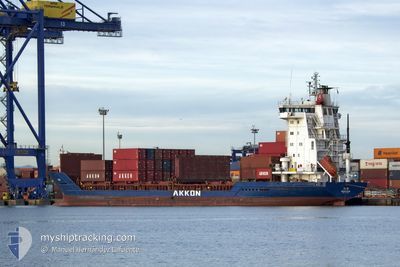
ELBE
Container Ship
Current Trip
| Time Travelled | 3 h, 28 mins |
|---|---|
| Remaining Time | 15 h, 26 mins |
| Distance Travelled | 4.35 nm |
| Remaining Distance | 208.27 nm |
| AVG Speed | 13 Knots |
| MAX Speed | 13 Knots |
| AVG Wind | 8.4 knots |
| MAX Wind | 9 knots |
| MIN Temp | 13.8°C / 56.84°F |
| MAX Temp | 14°C / 57.2°F |
| Draught | 7.1 m |
| Position Received | 12 d ago |
Current Position
| Longitude | 13.98485° |
|---|---|
| Latitude | 36.76967° |
| Status | Under way using engine |
| Speed | 13.5 Knots |
| Course | 286.5° |
| Area | Mediterranean Sea - Eastern Basin |
| Station | T-AIS |
| Position Received | 12 d ago |
Info
Information
The current position of ELBE is in Mediterranean Sea - Eastern Basin with coordinates 36.76967° / 13.98485° as reported on 2025-01-23 11:57 by AIS to our vessel tracker app. The vessel's current speed is 13.5 Knots and is heading at the port of ANNABA. The estimated time of arrival as calculated by MyShipTracking vessel tracking app is 2025-02-05 15:22 LT
The vessel ELBE (IMO: 9244180, MMSI: 636021322) is a Container Ship that was built in 2001 ( 24 years old ). It's sailing under the flag of [LR] Liberia.
In this page you can find informations about the vessels current position, last detected port calls, and current voyage information. If the vessels is not in coverage by AIS you will find the latest position.
The current position of ELBE is detected by our AIS receivers and we are not responsible for the reliability of the data. The last position was recorded while the vessel was in Coverage by the Ais receivers of our vessel tracking app.
The current draught of ELBE as reported by AIS is 7.1 meters
Weather
| Temperature | 12.9°C / 55.22°F |
|---|---|
| Wind Speed | 4 knots |
| Direction | 198° SSW |
| Pressure | 1029.5 hPa |
| Humidity | 79.5 % |
| Cloud Coverage | 21 % |
Featured Company
Last Port Calls
| Port | Arrival | Departure | Time In Port |
|---|---|---|---|
| 2025-01-31 21:00 | 2025-02-04 20:28 | 3 d | |
| 2025-01-24 15:29 | 2025-01-26 16:59 | 2 d | |
| 2025-01-19 10:36 | 2025-01-20 14:14 | 1 d | |
| 2025-01-18 14:59 | 2025-01-19 04:24 | 13 h | |
| 2025-01-18 02:32 | 2025-01-18 09:44 | 7 h | |
| 2025-01-02 00:24 | 2025-01-02 14:33 | 14 h | |
| 2024-12-25 19:04 | 2024-12-28 07:09 | 2 d | |
| 2024-12-16 10:57 | 2024-12-16 19:26 | 8 h | |
| 2024-12-15 13:40 | 2024-12-16 03:55 | 14 h | |
| 2024-12-14 10:01 | 2024-12-15 07:35 | 21 h |
Last Trips
| Origin | Departure | Destination | Arrival | Distance | |
|---|---|---|---|---|---|
| 2025-01-26 17:59 | 2025-01-31 22:00 | 497.13 nm | |||
| 2025-01-20 17:14 | 2025-01-24 16:29 | 1185.06 nm | |||
| 2025-01-19 07:24 | 2025-01-19 13:36 | 70.31 nm | |||
| 2025-01-18 12:44 | 2025-01-18 17:59 | 60.53 nm | |||
| 2025-01-02 17:33 | 2025-01-18 05:32 | 85.69 nm | |||
| 2024-12-28 08:09 | 2025-01-02 03:24 | 1394.30 nm | |||
| 2024-12-16 22:26 | 2024-12-25 20:04 | 1642.03 nm | |||
| 2024-12-16 06:55 | 2024-12-16 13:57 | 60.43 nm | |||
| 2024-12-15 10:35 | 2024-12-15 16:40 | 70.07 nm | |||
| 2024-12-07 18:42 | 2024-12-14 13:01 | 1663.12 nm |
Events
| Time | Event | Details | Position / Dest | Info |
|---|---|---|---|---|
| 2025-02-04 20:28 | PORT DEPARTURE |
|
37.00716 / 3.32652
DZAAE
|
Speed: 4.8 kn Course: 109° |
| 2025-02-04 20:14 | START Moving |
36.76269 / 3.07680
[DZ] ALGER
|
Speed: 4.8 kn Course: 109° |
|
| 2025-01-31 21:00 | PORT ARRIVAL |
|
36.76193 / 3.07981
[DZ] ALGER
|
Speed: 3.1 kn Course: 273° |
| 2025-01-31 20:22 | START Moving | 3.4 nm, East of ALGER |
36.78294 / 3.14025
DZAAE
|
Speed: 3.1 kn Course: 273° |
| 2025-01-28 05:12 | START Moving | 11.05 nm, North West of EL MARSA TAMANFOUSST |
36.96890 / 3.12366
DZAAE
|
Speed: 3.7 kn Course: 271° |
| 2025-01-27 19:27 | STOP Moving | 11.3 nm, North East of EL DJAMILA |
36.96907 / 3.00107
DZAAE
|
Speed: 0.2 kn Course: 267° |
| 2025-01-26 16:59 | START Moving | 0.28 nm, South East of ANNABA |
36.90189 / 7.78288
DZAAE
|
Speed: 4.8 kn Course: 114° |
| 2025-01-26 16:59 | PORT DEPARTURE |
|
36.90189 / 7.78288
DZAAE
|
Speed: 2.9 kn Course: 42° |