
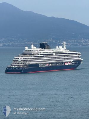
EXPLORA II
Passenger
Current Trip
| Trip Time | 10 h, 18 mins |
|---|---|
| Trip Distance | 165.77 nm |
| AVG Speed | 14.9 Knots |
| MAX Speed | 20 Knots |
| Draught | 7.1 m |
| AVG Wind | 6.3 knots |
| MAX Wind | 8.7 knots |
| MIN Temp | 21.5°C / 70.7°F |
| MAX Temp | 24°C / 75.2°F |
| Position Received | 2 m ago |
Current Position
| Longitude | -80.16491° |
|---|---|
| Latitude | 25.77490° |
| Status | Moored |
| Speed | |
| Course | 116° |
| Area | North Atlantic Ocean |
| Station | T-AIS |
| Position Received | 2 m ago |
Info
Information
The current position of EXPLORA II is in North Atlantic Ocean with coordinates 25.77490° / -80.16491° as reported on 2026-01-05 10:42 by AIS to our vessel tracker app. The vessel's current speed is 0 Knots and is currently inside the port of MIAMI.
The vessel EXPLORA II (IMO: 9869887, MMSI: 256798000) is a Passenger It's sailing under the flag of [MT] Malta.
In this page you can find informations about the vessels current position, last detected port calls, and current voyage information. If the vessels is not in coverage by AIS you will find the latest position.
The current position of EXPLORA II is detected by our AIS receivers and we are not responsible for the reliability of the data. The last position was recorded while the vessel was in Coverage by the Ais receivers of our vessel tracking app.
The current draught of EXPLORA II as reported by AIS is 7.1 meters
Weather
| Temperature | 21.7°C / 71.06°F |
|---|---|
| Wind Speed | 3 knots |
| Direction | 14° NNE |
| Pressure | 1017 hPa |
| Humidity | 71.8 % |
| Cloud Coverage | --- |
Featured Company
Last Port Calls
| Port | Arrival | Departure | Time In Port |
|---|---|---|---|
| 2026-01-05 03:27 | |||
| 2026-01-04 09:26 | 2026-01-04 17:09 | 7 h | |
| 2026-01-02 09:00 | 2026-01-02 17:20 | 8 h | |
| 2025-12-29 05:54 | 2025-12-29 19:41 | 13 h | |
| 2025-12-26 08:03 | 2025-12-26 19:55 | 11 h | |
| 2025-12-22 02:19 | 2025-12-22 19:28 | 17 h | |
| 2025-12-19 08:21 | 2025-12-19 17:15 | 8 h | |
| 2025-12-18 09:46 | 2025-12-18 20:04 | 10 h | |
| 2025-12-17 09:09 | 2025-12-17 19:58 | 10 h | |
| 2025-12-16 08:24 | 2025-12-16 18:00 | 9 h |
Last Trips
| Origin | Departure | Destination | Arrival | Distance | |
|---|---|---|---|---|---|
| 2026-01-04 17:09 | 2026-01-05 03:27 | 165.77 nm | |||
| 2026-01-02 17:20 | 2026-01-04 09:26 | 693.45 nm | |||
| 2025-12-29 19:41 | 2026-01-02 09:00 | 644.59 nm | |||
| 2025-12-26 19:55 | 2025-12-29 05:54 | 334.83 nm | |||
| 2025-12-22 19:28 | 2025-12-26 08:03 | 1080.40 nm | |||
| 2025-12-19 17:15 | 2025-12-22 02:19 | 1017.90 nm | |||
| 2025-12-18 20:04 | 2025-12-19 08:21 | 176.90 nm | |||
| 2025-12-17 19:58 | 2025-12-18 09:46 | 194.28 nm | |||
| 2025-12-16 18:00 | 2025-12-17 09:09 | 265.20 nm | |||
| 2025-12-14 19:29 | 2025-12-16 08:24 | 273.06 nm |
Events
| Time | Event | Details | Position / Dest | Info |
|---|---|---|---|---|
| 2026-01-05 09:49 | Status Changed | Moored Under way using engine |
25.77489 / -80.16490
[US] MIAMI
|
Speed: Course: 116° |
| 2026-01-05 09:20 | STOP Moving |
25.77497 / -80.16491
[US] MIAMI
|
Speed: 0.2 kn Course: 118° |
|
| 2026-01-05 08:27 | PORT ARRIVAL |
|
25.76287 / -80.13101
[US] MIAMI
|
Speed: 10.1 kn Course: 294.7° |
| 2026-01-05 07:33 | Destination Changed | USMIA PRSJU |
25.65420 / -80.00038
USMIA
|
Speed: 14.9 kn Course: 359.3° |
| 2026-01-05 07:33 | ETA Changed | 2026/01/05 08:00 2026/01/01 03:30 |
25.65420 / -80.00038
USMIA
|
Speed: 14.9 kn Course: 359.3° |
| 2026-01-05 06:53 | Status Changed | Under way using engine Default |
25.49687 / -79.99550
PRSJU
|
Speed: 14.4 kn Course: 358° |
| 2026-01-05 06:45 | Status Changed | Default Under way using engine |
25.46263 / -79.99430
PRSJU
|
Speed: 14.5 kn Course: 357.9° |
| 2026-01-05 06:24 | Change Sea Area | United States part of the North Atlantic Ocean Puerto Rican part of the North Atlantic Ocean |
25.37966 / -79.99151
North Atlantic Ocean
|
Speed: 14.8 kn Course: 358.3° |
| 2026-01-05 06:24 | Status Changed | Under way using engine Default |
25.37966 / -79.99151
PRSJU
|
Speed: 14.8 kn Course: 16° |
| 2026-01-05 06:05 | IN Coverage |
25.37966 / -79.99151
North Atlantic Ocean
|
Speed: 14.8 kn Course: 358.3° |