
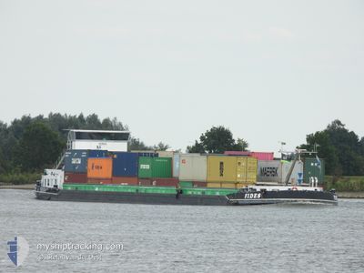
FIDES
Cargo
Current Trip
| Time Travelled | 2 h, 37 mins |
|---|---|
| Remaining Time | 3 h, 12 mins |
| Distance Travelled | 20.27 nm |
| Remaining Distance | 26.54 nm |
| AVG Speed | 8 Knots |
| MAX Speed | 8.5 Knots |
| AVG Wind | 4.4 knots |
| MAX Wind | 6 knots |
| MIN Temp | 5.3°C / 41.54°F |
| MAX Temp | 5.8°C / 42.44°F |
| Draught | 0 m |
| Position Received | 1 m ago |
Current Position
| Longitude | 4.65642° |
|---|---|
| Latitude | 51.89023° |
| Status | Under way using engine |
| Speed | 6.5 Knots |
| Course | 271.1° |
| Area | North Sea |
| Station | T-AIS |
| Position Received | 1 m ago |
Info
Information
The current position of FIDES is in North Sea with coordinates 51.89023° / 4.65642° as reported on 2025-12-13 21:18 by AIS to our vessel tracker app. The vessel's current speed is 6.5 Knots and is heading at the port of MAASVLAKTE - ROTTERDAM. The estimated time of arrival as calculated by MyShipTracking vessel tracking app is 2025-12-14 01:32 LT
The vessel FIDES (MMSI: 244650105) is a Cargo It's sailing under the flag of [NL] Netherlands.
In this page you can find informations about the vessels current position, last detected port calls, and current voyage information. If the vessels is not in coverage by AIS you will find the latest position.
The current position of FIDES is detected by our AIS receivers and we are not responsible for the reliability of the data. The last position was recorded while the vessel was in Coverage by the Ais receivers of our vessel tracking app.
Weather
| Temperature | 5.3°C / 41.54°F |
|---|---|
| Wind Speed | 6 knots |
| Direction | 198° SSW |
| Pressure | 1027.3 hPa |
| Humidity | 88.8 % |
| Cloud Coverage | 21 % |
Featured Company
Last Port Calls
| Port | Arrival | Departure | Time In Port |
|---|---|---|---|
| 2025-12-13 19:21 | 2025-12-13 19:43 | 22 m | |
| 2025-12-12 15:10 | 2025-12-12 16:02 | 51 m | |
| 2025-12-11 21:18 | 2025-12-12 14:13 | 16 h | |
| 2025-12-11 18:48 | 2025-12-11 20:36 | 1 h | |
| 2025-12-11 01:57 | 2025-12-11 02:32 | 34 m | |
| 2025-12-11 00:59 | 2025-12-11 01:49 | 49 m | |
| 2025-12-10 12:03 | 2025-12-10 21:06 | 9 h | |
| 2025-12-09 22:31 | 2025-12-10 09:34 | 11 h | |
| 2025-12-09 20:44 | 2025-12-09 21:41 | 56 m | |
| 2025-12-09 14:44 | 2025-12-09 15:19 | 34 m |
Most Visited Ports (Last year)
| Port | Arrivals | |
|---|---|---|
| 171 | ||
| 150 | ||
| 146 | ||
| 145 | ||
| 83 | ||
| 73 |
Last Trips
| Origin | Departure | Destination | Arrival | Distance | |
|---|---|---|---|---|---|
| 2025-12-12 16:02 | 2025-12-13 19:21 | 112.98 nm | |||
| 2025-12-12 14:13 | 2025-12-12 15:10 | 3.59 nm | |||
| 2025-12-11 20:36 | 2025-12-11 21:18 | 2.52 nm | |||
| 2025-12-11 02:32 | 2025-12-11 18:48 | 105.67 nm | |||
| 2025-12-11 01:49 | 2025-12-11 01:57 | 0.79 nm | |||
| 2025-12-10 21:06 | 2025-12-11 00:59 | 28.62 nm | |||
| 2025-12-10 09:34 | 2025-12-10 12:03 | 15.61 nm | |||
| 2025-12-09 21:41 | 2025-12-09 22:31 | 8.48 nm | |||
| 2025-12-09 15:19 | 2025-12-09 20:44 | 39.34 nm | |||
| 2025-12-08 20:03 | 2025-12-09 14:44 | 112.50 nm |
Events
| Time | Event | Details | Position / Dest | Info |
|---|---|---|---|---|
| 2025-12-13 21:11 | Status Changed | Under way using engine Default |
51.89198 / 4.67713
ROTTERDAM AMAZONEHAV
|
Speed: 6.6 kn Course: 249° |
| 2025-12-13 21:05 | Status Changed | Default Under way using engine |
51.89584 / 4.69333
ROTTERDAM AMAZONEHAV
|
Speed: 6.6 kn Course: 268.5° |
| 2025-12-13 18:43 | PORT DEPARTURE |
|
52.00469 / 5.10441
ROTTERDAM AMAZONEHAV
|
Speed: 7.2 kn Course: 206.7° |
| 2025-12-13 18:38 | START Moving |
52.01320 / 5.10930
[NL] NIEUWEGEIN
|
Speed: 3.4 kn Course: 193.9° |
|
| 2025-12-13 18:21 | STOP Moving |
52.01503 / 5.11028
[NL] NIEUWEGEIN
|
Speed: 0.3 kn Course: 511° |
|
| 2025-12-13 18:21 | PORT ARRIVAL |
|
52.01507 / 5.11024
[NL] NIEUWEGEIN
|
Speed: 1.5 kn Course: 511° |
| 2025-12-13 14:46 | START Moving | 0.28 nm, West of SCHELLINGWOUDE |
52.38063 / 4.95701
ROTTERDAM AMAZONEHAV
|
Speed: 4.5 kn Course: 282.7° |
| 2025-12-13 14:27 | STOP Moving | 0.18 nm, South West of SCHELLINGWOUDE |
52.37980 / 4.96029
ROTTERDAM AMAZONEHAV
|
Speed: 0.3 kn Course: 511° |
| 2025-12-13 11:39 | START Moving | 0.16 nm, West of LELYSTAD |
52.52592 / 5.43455
ROTTERDAM AMAZONEHAV
|
Speed: 3.6 kn Course: 186.3° |
| 2025-12-13 11:31 | STOP Moving | 0.18 nm, North West of LELYSTAD |
52.52804 / 5.43483
ROTTERDAM AMAZONEHAV
|
Speed: 0.3 kn Course: 511° |