
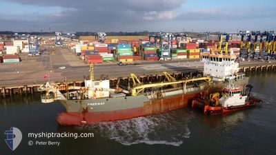
FREEWAY
Dredging or underwater ops
Current Trip
| Time Travelled | 4 days |
|---|---|
| Remaining Time | --- |
| Distance Travelled | 582.88 nm |
| Remaining Distance | --- |
| AVG Speed | 8.1 Knots |
| MAX Speed | 13.2 Knots |
| AVG Wind | 10.2 knots |
| MAX Wind | 31.3 knots |
| MIN Temp | 3.6°C / 38.48°F |
| MAX Temp | 11.7°C / 53.06°F |
| Draught | 4 m |
| Position Received | 1 m ago |
Current Position
| Longitude | -3.19852° |
|---|---|
| Latitude | 56.00319° |
| Status | Restricted manoeuverability |
| Speed | 2 Knots |
| Course | 125° |
| Area | North Sea |
| Station | T-AIS |
| Position Received | 1 m ago |
Info
Information
The current position of FREEWAY is in North Sea with coordinates 56.00319° / -3.19852° as reported on 2025-12-18 04:57 by AIS to our vessel tracker app. The vessel's current speed is 2 Knots
The vessel FREEWAY (IMO: 9691682, MMSI: 212368000) is a Dredging or underwater ops It's sailing under the flag of [CY] Cyprus.
In this page you can find informations about the vessels current position, last detected port calls, and current voyage information. If the vessels is not in coverage by AIS you will find the latest position.
The current position of FREEWAY is detected by our AIS receivers and we are not responsible for the reliability of the data. The last position was recorded while the vessel was in Coverage by the Ais receivers of our vessel tracking app.
The current draught of FREEWAY as reported by AIS is 4 meters
Weather
| Temperature | 7.4°C / 45.32°F |
|---|---|
| Wind Speed | 17 knots |
| Direction | 233° SW |
| Pressure | 996.1 hPa |
| Humidity | 78.4 % |
| Cloud Coverage | 51 % |
Featured Company
Last Port Calls
Most Visited Ports (Last year)
| Port | Arrivals | |
|---|---|---|
| 294 | ||
| 15 | ||
| 7 | ||
| 5 | ||
| 5 | ||
| 3 |
Last Trips
| Origin | Departure | Destination | Arrival | Distance | |
|---|---|---|---|---|---|
| 2025-12-02 04:32 | 2025-12-11 05:44 | 1185.49 nm | |||
| 2025-11-12 19:21 | 2025-11-29 23:59 | 1729.39 nm | |||
| 2025-10-21 17:36 | 2025-11-12 06:52 | 2156.34 nm | |||
| 2025-10-06 18:15 | 2025-10-20 06:22 | 1676.14 nm | |||
| 2025-09-17 11:39 | 2025-10-04 06:34 | 1865.29 nm |
Events
| Time | Event | Details | Position / Dest | Info |
|---|---|---|---|---|
| 2025-12-18 02:55 | START Moving | 2.65 nm, North East of LEITH |
56.01185 / -3.11759
LEITH
|
Speed: 7.1 kn Course: 264.9° |
| 2025-12-18 02:53 | STOP Moving | 2.74 nm, North East of LEITH |
56.01161 / -3.11409
LEITH
|
Speed: 0.3 kn Course: 267° |
| 2025-12-18 00:23 | START Moving | 2.51 nm, North East of LEITH |
56.01018 / -3.12036
LEITH
|
Speed: 7.9 kn Course: 261.8° |
| 2025-12-18 00:16 | STOP Moving | 2.61 nm, North East of LEITH |
56.01018 / -3.11693
LEITH
|
Speed: 0.3 kn Course: 55° |
| 2025-12-17 23:07 | START Moving | 2.49 nm, North East of LEITH |
56.01016 / -3.12130
LEITH
|
Speed: 8.6 kn Course: 264.2° |
| 2025-12-17 23:05 | STOP Moving | 2.59 nm, North East of LEITH |
56.01032 / -3.11770
LEITH
|
Speed: 0.3 kn Course: 260° |
| 2025-12-17 20:21 | START Moving | 1.32 nm, North East of GRANTON |
56.00645 / -3.20641
LEITH
|
Speed: 3.1 kn Course: 62° |
| 2025-12-17 19:56 | STOP Moving | 1.19 nm, North East of GRANTON |
56.00282 / -3.20289
LEITH
|
Speed: 0.1 kn Course: 144° |
| 2025-12-17 19:27 | START Moving | 2.5 nm, North East of LEITH |
56.00999 / -3.12079
LEITH
|
Speed: 8.1 kn Course: 263.7° |
| 2025-12-17 19:24 | STOP Moving | 2.59 nm, North East of LEITH |
56.01019 / -3.11749
LEITH
|
Speed: 0.2 kn Course: 261° |