
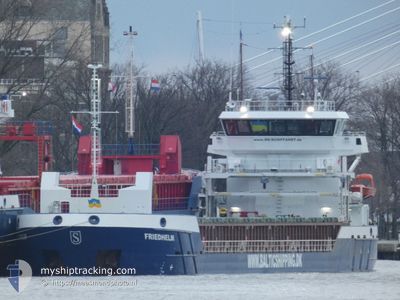
FRIEDHELM
Cargo
Current Trip
| Time Travelled | 2 days |
|---|---|
| Remaining Time | --- |
| Distance Travelled | 138.06 nm |
| Remaining Distance | --- |
| AVG Speed | 9.1 Knots |
| MAX Speed | 10.5 Knots |
| AVG Wind | 14.7 knots |
| MAX Wind | 22 knots |
| MIN Temp | 16.7°C / 62.06°F |
| MAX Temp | 18.9°C / 66.02°F |
| Draught | 3.5 m |
| Position Received | 14 d ago |
Current Position
| Longitude | 26.09740° |
|---|---|
| Latitude | 35.64111° |
| Status | Under way using engine |
| Speed | 9.8 Knots |
| Course | 176.7° |
| Area | Aegean Sea |
| Station | T-AIS |
| Position Received | 14 d ago |
Info
Information
The current position of FRIEDHELM is in Aegean Sea with coordinates 35.64111° / 26.09740° as reported on 2025-12-03 19:47 by AIS to our vessel tracker app. The vessel's current speed is 9.8 Knots and is heading at the port of SITIA.
The vessel FRIEDHELM (IMO: 9953951, MMSI: 255804550) is a Cargo It's sailing under the flag of [PT] Portugal.
In this page you can find informations about the vessels current position, last detected port calls, and current voyage information. If the vessels is not in coverage by AIS you will find the latest position.
The current position of FRIEDHELM is detected by our AIS receivers and we are not responsible for the reliability of the data. The last position was recorded while the vessel was in Coverage by the Ais receivers of our vessel tracking app.
The current draught of FRIEDHELM as reported by AIS is 3.5 meters
Weather
| Temperature | 18.3°C / 64.94°F |
|---|---|
| Wind Speed | 11 knots |
| Direction | 37° NE |
| Pressure | 1025.8 hPa |
| Humidity | 54.4 % |
| Cloud Coverage | 16 % |
Featured Company
Last Port Calls
| Port | Arrival | Departure | Time In Port |
|---|---|---|---|
| 2025-12-13 10:37 | 2025-12-15 12:30 | 2 d | |
| 2025-11-29 00:36 | 2025-11-29 19:01 | 18 h | |
| 2025-11-09 18:10 | 2025-11-10 17:15 | 23 h | |
| 2025-10-30 06:31 | 2025-11-01 07:39 | 2 d | |
| 2025-10-13 10:53 | 2025-10-17 02:14 | 3 d | |
| 2025-10-05 06:56 | 2025-10-07 08:20 | 2 d |
Last Trips
| Origin | Departure | Destination | Arrival | Distance | |
|---|---|---|---|---|---|
| 2025-11-29 19:01 | 2025-12-13 10:37 | 677.60 nm | |||
| 2025-11-10 17:15 | 2025-11-29 00:36 | 3789.58 nm | |||
| 2025-11-01 07:39 | 2025-11-09 18:10 | 779.70 nm | |||
| 2025-10-17 02:14 | 2025-10-30 06:31 | 2582.54 nm | |||
| 2025-10-07 08:20 | 2025-10-13 10:53 | 452.79 nm | |||
| 2025-09-18 13:40 | 2025-10-05 06:56 | 3612.96 nm |
Events
| Time | Event | Details | Position / Dest | Info |
|---|---|---|---|---|
| 2025-12-15 23:59 | STOP Moving | 8.24 nm, North of DAMIETTA |
31.60500 / 31.76333
GRJSH
|
Speed: Course: -1° |
| 2025-12-15 10:30 | PORT DEPARTURE |
|
31.16060 / 29.80746
GRJSH
|
Speed: 4.7 kn Course: 347° |
| 2025-12-15 10:14 | START Moving |
31.14225 / 29.79808
[EG] EL DEKHEILA
|
Speed: 5 kn Course: 40° |
|
| 2025-12-13 09:01 | STOP Moving |
31.13662 / 29.79519
[EG] EL DEKHEILA
|
Speed: 0.3 kn Course: 194° |
|
| 2025-12-13 08:37 | PORT ARRIVAL |
|
31.15456 / 29.80787
[EG] EL DEKHEILA
|
Speed: 7.6 kn Course: 174° |
| 2025-12-13 08:01 | START Moving | 3.7 nm, North West of EL DEKHEILA |
31.19518 / 29.76195
GRJSH
|
Speed: 5.7 kn Course: 108° |