
GLOBAL ARSENAL
General Cargo
Current Trip
| Time Travelled | 6 days |
|---|---|
| Remaining Time | --- |
| Distance Travelled | 1334.69 nm |
| Remaining Distance | --- |
| AVG Speed | 10.7 Knots |
| MAX Speed | 13.6 Knots |
| AVG Wind | 9 knots |
| MAX Wind | 19.8 knots |
| MIN Temp | 5.1°C / 41.18°F |
| MAX Temp | 17.9°C / 64.22°F |
| Draught | 6.4 m |
| Position Received | 23 h, 32 m ago |
Current Position
| Longitude | 29.90634° |
|---|---|
| Latitude | 43.15006° |
| Status | Under way using engine |
| Speed | 13.3 Knots |
| Course | 14.7° |
| Area | Black Sea |
| Station | T-AIS |
| Position Received | 23 h, 32 m ago |
Info
Information
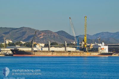
The current position of GLOBAL ARSENAL is in Black Sea with coordinates 43.15006° / 29.90634° as reported on 2025-12-17 08:50 by AIS to our vessel tracker app. The vessel's current speed is 13.3 Knots
The vessel GLOBAL ARSENAL (IMO: 9363302, MMSI: 314862000) is a General Cargo that was built in 2009 ( 16 years old ). It's sailing under the flag of [BB] Barbados.
In this page you can find informations about the vessels current position, last detected port calls, and current voyage information. If the vessels is not in coverage by AIS you will find the latest position.
The current position of GLOBAL ARSENAL is detected by our AIS receivers and we are not responsible for the reliability of the data. The last position was recorded while the vessel was in Coverage by the Ais receivers of our vessel tracking app.
The current draught of GLOBAL ARSENAL as reported by AIS is 6.4 meters
Weather
| Temperature | 10°C / 50°F |
|---|---|
| Wind Speed | 13 knots |
| Direction | 227° SW |
| Pressure | 1028.6 hPa |
| Humidity | 80.3 % |
| Cloud Coverage | 7 % |
Featured Company
Events
| Time | Event | Details | Position / Dest | Info |
|---|---|---|---|---|
| 2025-12-17 17:47 | STOP Moving | 21.16 nm, East of SFANTU GHEORGHE |
44.92598 / 30.08391
RO CND
|
Speed: 0.2 kn Course: 333° |
| 2025-12-17 08:54 | Status Changed | Default Under way using engine |
43.16740 / 29.91258
RO CND
|
Speed: 13.3 kn Course: 14.7° |
| 2025-12-17 08:50 | OUT of Coverage |
43.15006 / 29.90634
Black Sea
RO CND
|
Speed: 13.3 kn Course: 14.7° |
|
| 2025-12-17 08:48 | Status Changed | Under way using engine Default |
43.14467 / 29.90446
RO CND
|
Speed: 13.3 kn Course: 14° |
| 2025-12-17 08:45 | IN Coverage |
43.14467 / 29.90446
Black Sea
RO CND
|
Speed: 13.3 kn Course: 14.1° |
|
| 2025-12-17 07:34 | Status Changed | Default Under way using engine |
42.88195 / 29.79989
RO CND
|
Speed: 13.1 kn Course: 15.5° |
| 2025-12-17 07:27 | OUT of Coverage |
42.85981 / 29.79086
Black Sea
RO CND
|
Speed: 13.1 kn Course: 15.5° |
|
| 2025-12-17 07:04 | Status Changed | Under way using engine Default |
42.77832 / 29.75877
RO CND
|
Speed: 13.2 kn Course: 15° |
| 2025-12-17 06:44 | Status Changed | Default Under way using engine |
42.70649 / 29.73176
RO CND
|
Speed: 13.1 kn Course: 15.4° |
| 2025-12-17 06:37 | Status Changed | Under way using engine Default |
42.68237 / 29.72291
RO CND
|
Speed: 13.2 kn Course: 17° |