
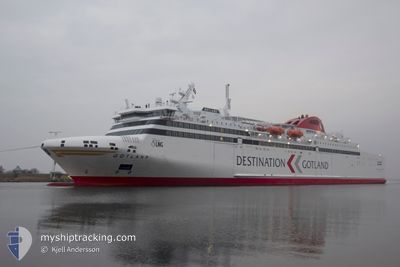
GOTLAND
Passenger
Current Trip
| Time Travelled | 3 h, 5 mins |
|---|---|
| Remaining Time | 17 mins |
| Distance Travelled | 69.28 nm |
| Remaining Distance | 15.37 nm |
| AVG Speed | 24.7 Knots |
| MAX Speed | 27.4 Knots |
| AVG Wind | 14.8 knots |
| MAX Wind | 18 knots |
| MIN Temp | -2.4°C / 27.68°F |
| MAX Temp | 0.4°C / 32.72°F |
| Draught | 6.4 m |
| Position Received | 1 m ago |
Current Position
| Longitude | 18.22234° |
|---|---|
| Latitude | 57.76402° |
| Status | Under way using engine |
| Speed | 27.3 Knots |
| Course | 176.6° |
| Area | Baltic Sea |
| Station | T-AIS |
| Position Received | 1 m ago |
Info
Information
The current position of GOTLAND is in Baltic Sea with coordinates 57.76402° / 18.22234° as reported on 2026-01-05 13:29 by AIS to our vessel tracker app. The vessel's current speed is 27.3 Knots and is heading at the port of VISBY. The estimated time of arrival as calculated by MyShipTracking vessel tracking app is 2026-01-05 13:48 LT
The vessel GOTLAND (IMO: 9783071, MMSI: 266444000) is a Passenger It's sailing under the flag of [SE] Sweden.
In this page you can find informations about the vessels current position, last detected port calls, and current voyage information. If the vessels is not in coverage by AIS you will find the latest position.
The current position of GOTLAND is detected by our AIS receivers and we are not responsible for the reliability of the data. The last position was recorded while the vessel was in Coverage by the Ais receivers of our vessel tracking app.
The current draught of GOTLAND as reported by AIS is 6.4 meters
Weather
| Temperature | 0.2°C / 32.36°F |
|---|---|
| Wind Speed | 17 knots |
| Direction | 93° E |
| Pressure | 1012.6 hPa |
| Humidity | 76.7 % |
| Cloud Coverage | 100 % |
Featured Company
Last Port Calls
| Port | Arrival | Departure | Time In Port |
|---|---|---|---|
| 2026-01-05 09:17 | 2026-01-05 10:26 | 1 h | |
| 2026-01-04 22:15 | 2026-01-05 06:13 | 7 h | |
| 2026-01-04 18:11 | 2026-01-04 19:15 | 1 h | |
| 2026-01-04 13:52 | 2026-01-04 15:03 | 1 h | |
| 2026-01-04 09:41 | 2026-01-04 10:52 | 1 h | |
| 2026-01-03 22:15 | 2026-01-04 06:28 | 8 h | |
| 2026-01-03 09:22 | 2026-01-03 19:01 | 9 h | |
| 2026-01-02 22:15 | 2026-01-03 06:19 | 8 h | |
| 2026-01-02 18:13 | 2026-01-02 19:11 | 57 m | |
| 2026-01-02 13:51 | 2026-01-02 15:15 | 1 h |
Most Visited Ports (Last year)
| Port | Arrivals | |
|---|---|---|
| 539 | ||
| 433 | ||
| 104 |
Last Trips
| Origin | Departure | Destination | Arrival | Distance | |
|---|---|---|---|---|---|
| 2026-01-05 07:13 | 2026-01-05 10:17 | 79.91 nm | |||
| 2026-01-04 20:15 | 2026-01-04 23:15 | 79.99 nm | |||
| 2026-01-04 16:03 | 2026-01-04 19:11 | 80.00 nm | |||
| 2026-01-04 11:52 | 2026-01-04 14:52 | 79.66 nm | |||
| 2026-01-04 07:28 | 2026-01-04 10:41 | 80.32 nm | |||
| 2026-01-03 20:01 | 2026-01-03 23:15 | 79.82 nm | |||
| 2026-01-03 07:19 | 2026-01-03 10:22 | 79.77 nm | |||
| 2026-01-02 20:11 | 2026-01-02 23:15 | 79.59 nm | |||
| 2026-01-02 16:15 | 2026-01-02 19:13 | 79.76 nm | |||
| 2026-01-02 11:25 | 2026-01-02 14:51 | 79.99 nm |
Events
| Time | Event | Details | Position / Dest | Info |
|---|---|---|---|---|
| 2026-01-05 12:39 | Status Changed | Under way using engine Default |
58.13786 / 18.17347
SE VBY
|
Speed: 27 kn Course: 177° |
| 2026-01-05 12:33 | IN Coverage |
58.12481 / 18.17460
Baltic Sea
SE VBY
|
Speed: 27 kn Course: 176.9° |
|
| 2026-01-05 11:53 | Status Changed | Default Under way using engine |
58.44923 / 18.13693
SE VBY
|
Speed: 21.7 kn Course: 178.5° |
| 2026-01-05 11:37 | OUT of Coverage |
58.54238 / 18.12696
Baltic Sea
SE VBY
|
Speed: 21.7 kn Course: 178.5° |
|
| 2026-01-05 10:26 | PORT DEPARTURE |
|
58.90899 / 17.96336
SE VBY
|
Speed: 8.2 kn Course: 40° |
| 2026-01-05 10:24 | START Moving |
58.90665 / 17.95975
[SE] NYNASHAMN
|
Speed: 6.1 kn Course: 39° |
|
| 2026-01-05 10:20 | Status Changed | Under way using engine Moored |
58.90489 / 17.95701
[SE] NYNASHAMN
|
Speed: Course: 22° |
| 2026-01-05 09:55 | Status Changed | Moored Default |
58.90489 / 17.95701
[SE] NYNASHAMN
|
Speed: Course: 23° |
| 2026-01-05 09:51 | Destination Changed | SE VBY SE NYN |
58.90488 / 17.95701
[SE] NYNASHAMN
|
Speed: Course: 23° |
| 2026-01-05 09:51 | ETA Changed | 2026/01/05 14:00 2026/01/05 09:30 |
58.90488 / 17.95701
[SE] NYNASHAMN
|
Speed: Course: 23° |