

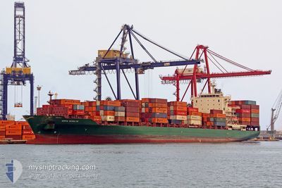
GSL MERCER
Container Ship

Current Trip
PAMIT
| Time Travelled | 1 day |
|---|---|
| Remaining Time | --- |
| Distance Travelled | 445.74 nm |
| Remaining Distance | --- |
| AVG Speed | 15.4 Knots |
| MAX Speed | 18 Knots |
| AVG Wind | 11.2 knots |
| MAX Wind | 14 knots |
| MIN Temp | 25.6°C / 78.08°F |
| MAX Temp | 28.6°C / 83.48°F |
| Draught | 9.4 m |
| Position Received | 2 h, 11 m ago |
Current Position
| Longitude | -50.68075° |
|---|---|
| Latitude | 4.46439° |
| Status | Under way using engine |
| Speed | 16 Knots |
| Course | 320° |
| Area | North Atlantic Ocean |
| Station | T-AIS |
| Position Received | 2 h, 11 m ago |
Information
The current position of GSL MERCER is in North Atlantic Ocean with coordinates 4.46439° / -50.68075° as reported on 2025-05-31 16:10 by AIS to our vessel tracker app. The vessel's current speed is 16 Knots
The vessel GSL MERCER (IMO: 9337274, MMSI: 636018378) is a Container Ship that was built in 2007 ( 18 years old ). It's sailing under the flag of [LR] Liberia.
In this page you can find informations about the vessels current position, last detected port calls, and current voyage information. If the vessels is not in coverage by AIS you will find the latest position.
The current position of GSL MERCER is detected by our AIS receivers and we are not responsible for the reliability of the data. The last position was recorded while the vessel was in Coverage by the Ais receivers of our vessel tracking app.
The current draught of GSL MERCER as reported by AIS is 9.4 meters
Weather
| Temperature | 27.6°C / 81.68°F |
|---|---|
| Wind Speed | 12 knots |
| Direction | 88° E |
| Pressure | 1013.9 hPa |
| Humidity | 77.9 % |
| Cloud Coverage | 24 % |


Featured Company
Last Port Calls
| Port | Arrival | Departure | Time In Port |
|---|---|---|---|
| 2025-05-28 05:24 | 2025-05-30 08:33 | 2 d | |
| 2025-05-21 21:26 | 2025-05-24 07:13 | 2 d | |
| 2025-05-11 02:48 | 2025-05-12 16:48 | 1 d | |
| 2025-05-09 22:12 | 2025-05-10 16:04 | 17 h | |
| 2025-05-08 16:24 | 2025-05-09 04:07 | 11 h | |
| 2025-04-29 07:20 | 2025-04-30 15:27 | 1 d | |
| 2025-04-22 17:10 | 2025-04-25 11:26 | 2 d | |
| 2025-04-15 16:52 | 2025-04-17 03:40 | 1 d | |
| 2025-04-11 18:12 | 2025-04-12 18:01 | 23 h | |
| 2025-04-09 01:05 | 2025-04-11 17:00 | 2 d |
Most Visited Ports (Last year)
| Port | Arrivals | |
|---|---|---|
| 11 | ||
| 10 | ||
| 10 | ||
| 9 | ||
| 7 | ||
| 5 |
Last Trips
| Origin | Departure | Destination | Arrival | Distance | |
|---|---|---|---|---|---|
| 2025-05-24 07:13 | 2025-05-28 05:24 | 1152.24 nm | |||
| 2025-05-12 16:48 | 2025-05-21 21:26 | 3012.01 nm | |||
| 2025-05-10 16:04 | 2025-05-11 02:48 | 15.10 nm | |||
| 2025-05-09 04:07 | 2025-05-09 22:12 | 284.35 nm | |||
| 2025-04-30 15:27 | 2025-05-08 16:24 | 2211.08 nm | |||
| 2025-04-25 11:26 | 2025-04-29 07:20 | 1136.92 nm | |||
| 2025-04-17 03:40 | 2025-04-22 17:10 | 1966.28 nm | |||
| 2025-04-12 18:01 | 2025-04-15 16:52 | 1179.32 nm | |||
| 2025-04-11 17:00 | 2025-04-11 18:12 | 9.02 nm | |||
| 2025-04-08 08:13 | 2025-04-09 01:05 | 282.11 nm |
Events
| Time | Event | Details | Position / Dest | Info |
|---|---|---|---|---|
| 2025-05-31 16:21 | Status Changed | Default Under way using engine |
4.50387 / -50.71387
PAMIT
|
Speed: 16 kn Course: 320° |
| 2025-05-31 16:10 | OUT of Coverage |
4.46439 / -50.68075
North Atlantic Ocean
|
Speed: 16 kn Course: 320° |
|
| 2025-05-31 15:55 | Status Changed | Under way using engine Default |
4.40867 / -50.63402
PAMIT
|
Speed: 16.4 kn Course: 321° |
| 2025-05-31 15:49 | Status Changed | Default Under way using engine |
4.38952 / -50.61825
PAMIT
|
Speed: 16 kn Course: 323° |
| 2025-05-31 14:10 | Status Changed | Under way using engine Default |
4.04223 / -50.33974
PAMIT
|
Speed: 15.6 kn Course: 322° |
| 2025-05-31 14:05 | Status Changed | Default Under way using engine |
4.02329 / -50.32420
PAMIT
|
Speed: 15 kn Course: 317° |
| 2025-05-31 13:50 | Status Changed | Under way using engine Default |
3.97210 / -50.28163
PAMIT
|
Speed: 15.7 kn Course: 322° |
| 2025-05-31 13:46 | Status Changed | Default Under way using engine |
3.95917 / -50.27095
PAMIT
|
Speed: 15 kn Course: 319° |
| 2025-05-31 13:38 | Change Sea Area | Brazilian part of the North Atlantic Ocean Colombian part of the Caribbean Sea |
3.93141 / -50.24886
North Atlantic Ocean
|
Speed: 15 kn Course: 319° |
| 2025-05-31 13:35 | IN Coverage |
3.93141 / -50.24886
North Atlantic Ocean
|
Speed: 15 kn Course: 319° |