
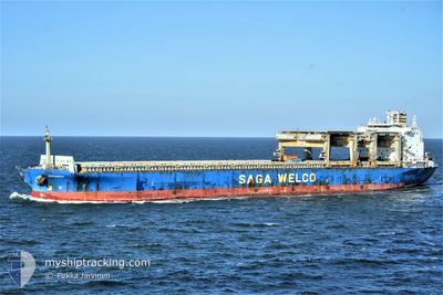
HERANGER
General Cargo
Current Trip
| Time Travelled | 7 h, 38 mins |
|---|---|
| Remaining Time | 6 h, 31 mins |
| Distance Travelled | 90.31 nm |
| Remaining Distance | 79.15 nm |
| AVG Speed | 11.2 Knots |
| MAX Speed | 13.7 Knots |
| AVG Wind | 8.1 knots |
| MAX Wind | 15.9 knots |
| MIN Temp | 4.1°C / 39.38°F |
| MAX Temp | 5.3°C / 41.54°F |
| Draught | 7.8 m |
| Position Received | 1 m ago |
Current Position
| Longitude | 2.27212° |
|---|---|
| Latitude | 51.70369° |
| Status | Under way using engine |
| Speed | 10.9 Knots |
| Course | 223° |
| Area | North Sea |
| Station | T-AIS |
| Position Received | 1 m ago |
Info
Information
The current position of HERANGER is in North Sea with coordinates 51.70369° / 2.27212° as reported on 2025-02-13 02:01 by AIS to our vessel tracker app. The vessel's current speed is 10.9 Knots and is heading at the port of TILBURY. The estimated time of arrival as calculated by MyShipTracking vessel tracking app is 2025-02-13 08:34 LT
The vessel HERANGER (IMO: 9079121, MMSI: 538009776) is a General Cargo that was built in 1995 ( 30 years old ). It's sailing under the flag of [MH] Marshall Is.
In this page you can find informations about the vessels current position, last detected port calls, and current voyage information. If the vessels is not in coverage by AIS you will find the latest position.
The current position of HERANGER is detected by our AIS receivers and we are not responsible for the reliability of the data. The last position was recorded while the vessel was in Coverage by the Ais receivers of our vessel tracking app.
The current draught of HERANGER as reported by AIS is 7.8 meters
Weather
| Temperature | 5.2°C / 41.36°F |
|---|---|
| Wind Speed | 16 knots |
| Direction | 6° N |
| Pressure | 1020.2 hPa |
| Humidity | 75.2 % |
| Cloud Coverage | 100 % |
Featured Company
Last Port Calls
| Port | Arrival | Departure | Time In Port |
|---|---|---|---|
| 2025-02-07 20:39 | 2025-02-12 18:25 | 4 d | |
| 2025-02-01 20:14 | 2025-02-06 03:03 | 4 d | |
| 2025-01-28 15:01 | 2025-01-29 15:18 | 1 d |
Most Visited Ports (Last year)
| Port | Arrivals | |
|---|---|---|
| 2 | ||
| 2 | ||
| 2 | ||
| 1 | ||
| 1 | ||
| 1 |
Events
| Time | Event | Details | Position / Dest | Info |
|---|---|---|---|---|
| 2025-02-13 00:37 | Change Sea Area | United Kingdom part of the North Sea Dutch part of the North Sea |
51.90604 / 2.56344
North Sea
NLRTM >> GBTIL
|
Speed: 12.2 kn Course: 226.4° |
| 2025-02-13 00:07 | ETA Changed | 2025/02/13 08:00 2025/02/13 06:00 |
51.96536 / 2.70688
NLRTM >> GBTIL
|
Speed: 12.7 kn Course: 228.1° |
| 2025-02-12 18:25 | PORT DEPARTURE |
|
51.90208 / 4.43163
NLRTM >> GBTIL
|
Speed: 4.9 kn Course: 285° |
| 2025-02-12 18:22 | START Moving |
51.89861 / 4.43589
[NL] ROTTERDAM WAALHAVEN
|
Speed: 4.9 kn Course: 336° |
|
| 2025-02-12 17:49 | Status Changed | Under way using engine Moored |
51.89423 / 4.44885
[NL] ROTTERDAM WAALHAVEN
|
Speed: 0.4 kn Course: 106° |
| 2025-02-12 16:28 | Draught Changed | 7.8 7.9 |
51.89390 / 4.44864
[NL] ROTTERDAM WAALHAVEN
|
Speed: Course: 105° |
| 2025-02-12 14:27 | Draught Changed | 7.9 9.3 |
51.89393 / 4.44865
[NL] ROTTERDAM WAALHAVEN
|
Speed: Course: 104° |
| 2025-02-12 14:27 | Destination Changed | NLRTM >> GBTIL GBTYN >> NLRTM |
51.89393 / 4.44865
[NL] ROTTERDAM WAALHAVEN
|
Speed: Course: 104° |
| 2025-02-12 14:27 | ETA Changed | 2025/02/13 06:00 2025/02/07 18:30 |
51.89393 / 4.44865
[NL] ROTTERDAM WAALHAVEN
|
Speed: Course: 104° |
| 2025-02-08 01:58 | Status Changed | Moored Default |
51.89391 / 4.44864
[NL] ROTTERDAM WAALHAVEN
|
Speed: Course: 105° |