
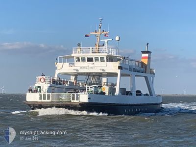
HILLIGENLEI
Ro-Ro/Passenger Ship
Current Trip
HOOGE LANG. SCHLUETT
| Time Travelled | 2 days |
|---|---|
| Remaining Time | --- |
| Distance Travelled | 187.22 nm |
| Remaining Distance | --- |
| AVG Speed | 7.8 Knots |
| MAX Speed | 11.8 Knots |
| AVG Wind | 12.6 knots |
| MAX Wind | 22.6 knots |
| MIN Temp | 0.4°C / 32.72°F |
| MAX Temp | 5°C / 41°F |
| Draught | 1.6 m |
| Position Received | 1 m ago |
Current Position
| Longitude | 8.75359° |
|---|---|
| Latitude | 54.68166° |
| Status | Moored |
| Speed | |
| Course | 274° |
| Area | North Sea |
| Station | T-AIS |
| Position Received | 1 m ago |
Info
Information
The current position of HILLIGENLEI is in North Sea with coordinates 54.68166° / 8.75359° as reported on 2025-02-08 14:19 by AIS to our vessel tracker app. The vessel's current speed is 0 Knots
The vessel HILLIGENLEI (IMO: 8411217, MMSI: 211379770) is a Ro-Ro/Passenger Ship that was built in 1985 ( 40 years old ). It's sailing under the flag of [DE] Germany.
In this page you can find informations about the vessels current position, last detected port calls, and current voyage information. If the vessels is not in coverage by AIS you will find the latest position.
The current position of HILLIGENLEI is detected by our AIS receivers and we are not responsible for the reliability of the data. The last position was recorded while the vessel was in Coverage by the Ais receivers of our vessel tracking app.
The current draught of HILLIGENLEI as reported by AIS is 1.6 meters
Weather
| Temperature | 3.2°C / 37.76°F |
|---|---|
| Wind Speed | 13 knots |
| Direction | 101° E |
| Pressure | 1027.4 hPa |
| Humidity | 74.8 % |
| Cloud Coverage | 100 % |
Featured Company
Most Visited Ports (Last year)
| Port | Arrivals | |
|---|---|---|
| 1 | ||
| 1 | ||
| 1 |
Last Trips
| Origin | Departure | Destination | Arrival | Distance |
|---|
Events
| Time | Event | Details | Position / Dest | Info |
|---|---|---|---|---|
| 2025-02-08 14:07 | Status Changed | Moored Default |
54.68163 / 8.75356
HOOGE LANG. SCHLUETT
|
Speed: Course: 274° |
| 2025-02-08 14:04 | Status Changed | Default Moored |
54.68165 / 8.75356
HOOGE LANG. SCHLUETT
|
Speed: Course: 274° |
| 2025-02-08 13:10 | Status Changed | Moored Under way using engine |
54.68168 / 8.75363
HOOGE LANG. SCHLUETT
|
Speed: Course: 273° |
| 2025-02-08 12:51 | STOP Moving | 3.77 nm, South East of DAGEBUELL |
54.68171 / 8.75330
HOOGE LANG. SCHLUETT
|
Speed: 0.3 kn Course: 223° |
| 2025-02-08 11:15 | START Moving | 5.89 nm, North West of TAMMENSIEL |
54.58031 / 8.55347
HOOGE LANG. SCHLUETT
|
Speed: 9.7 kn Course: 296° |
| 2025-02-08 11:04 | STOP Moving | 5.77 nm, North West of TAMMENSIEL |
54.57910 / 8.55625
HOOGE LANG. SCHLUETT
|
Speed: 0.2 kn Course: 138° |
| 2025-02-08 10:31 | START Moving | 4.79 nm, South of WYK AUF FOHR |
54.61580 / 8.54862
HOOGE LANG. SCHLUETT
|
Speed: 3.9 kn Course: 269° |
| 2025-02-08 10:15 | STOP Moving | 4.68 nm, South of WYK AUF FOHR |
54.61761 / 8.54855
HOOGE LANG. SCHLUETT
|
Speed: 0.1 kn Course: 351° |
| 2025-02-08 09:43 | START Moving | 5.89 nm, North West of TAMMENSIEL |
54.58030 / 8.55343
HOOGE LANG. SCHLUETT
|
Speed: 8.3 kn Course: 284.9° |
| 2025-02-08 09:34 | STOP Moving | 5.77 nm, North West of TAMMENSIEL |
54.57910 / 8.55613
HOOGE LANG. SCHLUETT
|
Speed: 0.2 kn Course: 112° |