
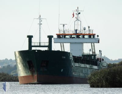
JOMI
General Cargo
Current Trip
| Time Travelled | 7 days |
|---|---|
| Remaining Time | 4 days |
| Distance Travelled | 1082.22 nm |
| Remaining Distance | 997.33 nm |
| AVG Speed | 9.2 Knots |
| MAX Speed | 11.5 Knots |
| AVG Wind | 16 knots |
| MAX Wind | 24 knots |
| MIN Temp | -1.5°C / 29.3°F |
| MAX Temp | 5.9°C / 42.62°F |
| Draught | 5.9 m |
| Position Received | 1 m ago |
Current Position
| Longitude | 7.05292° |
|---|---|
| Latitude | 57.79624° |
| Status | Under way using engine |
| Speed | 11.2 Knots |
| Course | 275° |
| Area | North Sea |
| Station | T-AIS |
| Position Received | 1 m ago |
Info
Information
The current position of JOMI is in North Sea with coordinates 57.79624° / 7.05292° as reported on 2025-02-13 05:18 by AIS to our vessel tracker app. The vessel's current speed is 11.2 Knots and is heading at the port of REYKJAVIK. The estimated time of arrival as calculated by MyShipTracking vessel tracking app is 2025-02-17 09:56 LT
The vessel JOMI (IMO: 9038397, MMSI: 309701000) is a General Cargo that was built in 1991 ( 34 years old ). It's sailing under the flag of [BS] Bahamas.
In this page you can find informations about the vessels current position, last detected port calls, and current voyage information. If the vessels is not in coverage by AIS you will find the latest position.
The current position of JOMI is detected by our AIS receivers and we are not responsible for the reliability of the data. The last position was recorded while the vessel was in Coverage by the Ais receivers of our vessel tracking app.
The current draught of JOMI as reported by AIS is 5.9 meters
Weather
| Temperature | 0.5°C / 32.9°F |
|---|---|
| Wind Speed | 17 knots |
| Direction | 55° NE |
| Pressure | 1026.6 hPa |
| Humidity | 80.6 % |
| Cloud Coverage | 66 % |
Featured Company
Last Port Calls
| Port | Arrival | Departure | Time In Port |
|---|---|---|---|
| 2025-02-04 13:29 | 2025-02-05 16:09 | 1 d | |
| 2025-01-31 01:07 | 2025-02-03 15:48 | 3 d | |
| 2025-01-24 05:04 | 2025-01-28 15:04 | 4 d | |
| 2025-01-16 13:18 | 2025-01-17 21:16 | 1 d | |
| 2025-01-15 00:18 | 2025-01-16 02:29 | 1 d | |
| 2025-01-10 17:57 | 2025-01-11 21:11 | 1 d | |
| 2025-01-08 00:14 | 2025-01-09 16:03 | 1 d | |
| 2024-12-29 10:49 | 2024-12-30 21:02 | 1 d | |
| 2024-12-26 10:05 | 2024-12-29 08:28 | 2 d | |
| 2024-12-19 18:49 | 2024-12-21 17:35 | 1 d |
Last Trips
| Origin | Departure | Destination | Arrival | Distance | |
|---|---|---|---|---|---|
| 2025-02-03 15:48 | 2025-02-04 13:29 | 203.45 nm | |||
| 2025-01-28 15:04 | 2025-01-31 01:07 | 498.21 nm | |||
| 2025-01-17 21:16 | 2025-01-24 05:04 | 446.38 nm | |||
| 2025-01-16 02:29 | 2025-01-16 13:18 | 94.93 nm | |||
| 2025-01-11 21:11 | 2025-01-15 00:18 | 675.53 nm | |||
| 2025-01-09 16:03 | 2025-01-10 17:57 | 267.27 nm | |||
| 2024-12-30 21:02 | 2025-01-08 00:14 | 765.79 nm | |||
| 2024-12-29 08:28 | 2024-12-29 10:49 | 23.31 nm | |||
| 2024-12-21 17:35 | 2024-12-26 10:05 | 1013.03 nm | |||
| 2024-12-18 17:40 | 2024-12-19 18:49 | 242.64 nm |
Events
| Time | Event | Details | Position / Dest | Info |
|---|---|---|---|---|
| 2025-02-13 04:20 | Change Sea Area | Norwegian part of the North Sea Norwegian part of the Skaggerak |
57.78565 / 7.37434
North Sea
REYKJAVIK
|
Speed: 10 kn Course: 271.8° |
| 2025-02-12 22:45 | Change Sea Area | Norwegian part of the Skaggerak Danish part of the Skaggerak |
57.79826 / 9.05677
Skaggerak
REYKJAVIK
|
Speed: 10.3 kn Course: 268.2° |
| 2025-02-12 17:05 | Change Sea Area | Danish part of the Skaggerak Danish part of the Kattegat |
57.77510 / 10.78881
Skaggerak
REYKJAVIK
|
Speed: 10.1 kn Course: 2.7° |
| 2025-02-12 15:56 | START Moving | 1.45 nm, South of SKAGEN |
57.69042 / 10.60962
REYKJAVIK
|
Speed: 3.2 kn Course: 74° |
| 2025-02-12 15:47 | Status Changed | Under way using engine At anchor |
57.69024 / 10.60470
REYKJAVIK
|
Speed: 0.1 kn Course: 74° |
| 2025-02-12 07:17 | Status Changed | At anchor Under way using engine |
57.69074 / 10.60510
REYKJAVIK
|
Speed: 0.3 kn Course: 126° |
| 2025-02-12 07:05 | STOP Moving | 1.44 nm, South of SKAGEN |
57.69010 / 10.60622
REYKJAVIK
|
Speed: 0.3 kn Course: 81° |
| 2025-02-12 03:52 | Change Sea Area | Danish part of the Kattegat Swedish part of the Kattegat |
57.50696 / 11.33732
Kattegat
REYKJAVIK
|
Speed: 8.3 kn Course: 294.2° |
| 2025-02-11 17:10 | Detected in Sea | Swedish part of the Kattegat |
56.16992 / 12.44970
Kattegat
REYKJAVIK
|
Speed: 10.5 kn Course: 315.1° |
| 2025-02-11 17:07 | Detected in Sea | Danish part of the Kattegat |
56.16405 / 12.46030
Kattegat
REYKJAVIK
|
Speed: 10.7 kn Course: 314.8° |